Duval County Rolled Sketch 42
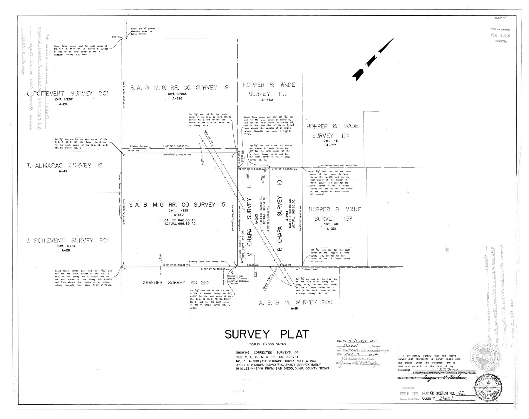
Survey plat showing corrected sureys of the S. A. & M. G. RR. Co. survey no. 5, A-530; the V. Chapa survey no. 11, A-203 and the P. Chapa survey 10, A-204
-
Map/Doc
5759
-
Collection
General Map Collection
-
Object Dates
1973 (Creation Date)
1974/11/9 (File Date)
-
People and Organizations
A.T. Trejo (Surveyor/Engineer)
-
Counties
Duval
-
Subjects
Surveying Rolled Sketch
-
Height x Width
23.6 x 29.8 inches
59.9 x 75.7 cm
-
Scale
1" = 300 varas
Part of: General Map Collection
Winkler County Sketch File 1 and 2

Print $64.00
- Digital $50.00
Winkler County Sketch File 1 and 2
1900
Size 8.4 x 9.2 inches
Map/Doc 40431
Matagorda County NRC Article 33.136 Sketch 16

Digital $50.00
Matagorda County NRC Article 33.136 Sketch 16
2023
Map/Doc 97256
Hardin County Sketch File 53

Print $12.00
- Digital $50.00
Hardin County Sketch File 53
Size 11.4 x 8.8 inches
Map/Doc 25213
Glasscock County

Print $20.00
- Digital $50.00
Glasscock County
1887
Size 20.5 x 19.5 inches
Map/Doc 3584
[Sketch for Mineral Application 20124, North Fork of Red River]
![2826, [Sketch for Mineral Application 20124, North Fork of Red River], General Map Collection](https://historictexasmaps.com/wmedia_w700/maps/2826.tif.jpg)
Print $20.00
- Digital $50.00
[Sketch for Mineral Application 20124, North Fork of Red River]
1943
Size 18.5 x 26.0 inches
Map/Doc 2826
Cooke County Sketch File 16-17-18

Print $16.00
- Digital $50.00
Cooke County Sketch File 16-17-18
1860
Size 12.7 x 8.1 inches
Map/Doc 19252
Jim Hogg County Boundary File 1

Print $16.00
- Digital $50.00
Jim Hogg County Boundary File 1
Size 11.4 x 8.8 inches
Map/Doc 55519
Sutton County Working Sketch 3

Print $20.00
- Digital $50.00
Sutton County Working Sketch 3
1968
Size 23.6 x 34.5 inches
Map/Doc 62346
Mitchell County Rolled Sketch 3

Print $40.00
- Digital $50.00
Mitchell County Rolled Sketch 3
1940
Size 39.6 x 49.0 inches
Map/Doc 9524
Val Verde County Sketch File Z7

Print $20.00
- Digital $50.00
Val Verde County Sketch File Z7
Size 25.6 x 17.2 inches
Map/Doc 12552
Flight Mission No. BRA-17M, Frame 16, Jefferson County

Print $20.00
- Digital $50.00
Flight Mission No. BRA-17M, Frame 16, Jefferson County
1953
Size 18.5 x 22.3 inches
Map/Doc 85797
Sectional Map No. 2 of the lands and the line of the Texas & Pacific Ry. Co. in Howard, Martin, Andrews, Midland and Tom Green Counties

Print $20.00
- Digital $50.00
Sectional Map No. 2 of the lands and the line of the Texas & Pacific Ry. Co. in Howard, Martin, Andrews, Midland and Tom Green Counties
1885
Size 18.9 x 23.2 inches
Map/Doc 4861
You may also like
Uvalde County Working Sketch 47

Print $20.00
- Digital $50.00
Uvalde County Working Sketch 47
1979
Size 29.7 x 24.8 inches
Map/Doc 72117

Galveston County Rolled Sketch 41

Print $20.00
- Digital $50.00
Galveston County Rolled Sketch 41
1988
Size 23.1 x 37.0 inches
Map/Doc 5972
Liberty County Rolled Sketch 15

Print $20.00
- Digital $50.00
Liberty County Rolled Sketch 15
2015
Size 36.1 x 24.4 inches
Map/Doc 94023
Harris County Rolled Sketch 86

Print $20.00
- Digital $50.00
Harris County Rolled Sketch 86
1947
Size 38.3 x 34.1 inches
Map/Doc 73577
The Republic County of Goliad. December 31, 1838

Print $20.00
The Republic County of Goliad. December 31, 1838
2020
Size 15.1 x 21.7 inches
Map/Doc 96149
Pecos County Rolled Sketch 44A

Print $20.00
- Digital $50.00
Pecos County Rolled Sketch 44A
1912
Size 19.7 x 34.6 inches
Map/Doc 7223
Donley County Sketch File 23

Print $4.00
- Digital $50.00
Donley County Sketch File 23
Size 8.4 x 14.5 inches
Map/Doc 21258
Val Verde County Sketch File D

Print $20.00
- Digital $50.00
Val Verde County Sketch File D
1899
Size 29.8 x 40.0 inches
Map/Doc 10422
Midland County Working Sketch 8

Print $20.00
- Digital $50.00
Midland County Working Sketch 8
1950
Size 41.4 x 32.9 inches
Map/Doc 70988
General Highway Map, Waller County, Texas

Print $20.00
General Highway Map, Waller County, Texas
1961
Size 24.9 x 18.2 inches
Map/Doc 79700
[Map of the Stockdale-Cuero Extension G.H. & S.A. Ry.]
![64096, [Map of the Stockdale-Cuero Extension G.H. & S.A. Ry.], General Map Collection](https://historictexasmaps.com/wmedia_w700/maps/64096.tif.jpg)
Print $40.00
- Digital $50.00
[Map of the Stockdale-Cuero Extension G.H. & S.A. Ry.]
1905
Size 19.4 x 118.2 inches
Map/Doc 64096