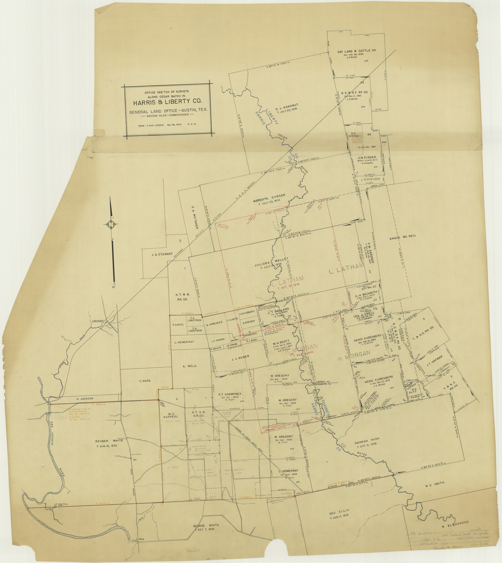
Harris County Rolled Sketch 86
Office Sketch of surveys along Cedar Bayou in Harris & Liberty Co.
-
Map/Doc
73577
-
Collection
General Map Collection
-
Object Dates
1947/4/28 (Creation Date)
-
Counties
Harris Liberty Chambers
-
Subjects
Surveying Rolled Sketch
-
Height x Width
38.3 x 34.1 inches
97.3 x 86.6 cm
-
Medium
paper, manuscript
-
Scale
1" = 2000 feet
Part of: General Map Collection
Wheeler County

Print $20.00
- Digital $50.00
Wheeler County
1899
Size 44.2 x 38.7 inches
Map/Doc 63121
Potter County Boundary File 3b

Print $12.00
- Digital $50.00
Potter County Boundary File 3b
Size 9.8 x 6.4 inches
Map/Doc 57979
Reagan County Working Sketch 28

Print $40.00
- Digital $50.00
Reagan County Working Sketch 28
1963
Size 55.7 x 42.4 inches
Map/Doc 71870
Cottle County Working Sketch 6

Print $20.00
- Digital $50.00
Cottle County Working Sketch 6
1927
Size 23.0 x 29.3 inches
Map/Doc 68316
Map of Dallas & Greenville Railroad through Dallas County, Texas

Print $2.00
- Digital $50.00
Map of Dallas & Greenville Railroad through Dallas County, Texas
Size 14.8 x 4.5 inches
Map/Doc 64487

Coke County Sketch File 15

Print $12.00
- Digital $50.00
Coke County Sketch File 15
1893
Size 5.6 x 8.6 inches
Map/Doc 18600

Sabine County Rolled Sketch 2

Print $20.00
- Digital $50.00
Sabine County Rolled Sketch 2
1949
Size 33.3 x 20.8 inches
Map/Doc 7551
Right of Way and Track Map of The Missouri, Kansas & Texas Railway of Texas

Print $40.00
- Digital $50.00
Right of Way and Track Map of The Missouri, Kansas & Texas Railway of Texas
1918
Size 24.4 x 50.7 inches
Map/Doc 64538
Montgomery County Working Sketch 1

Print $20.00
- Digital $50.00
Montgomery County Working Sketch 1
1912
Size 20.8 x 17.1 inches
Map/Doc 71107
Geological Highway Map of Texas

Geological Highway Map of Texas
1973
Size 28.4 x 36.2 inches
Map/Doc 74356
You may also like
[Surveys along Bray's Bayou]
![157, [Surveys along Bray's Bayou], General Map Collection](https://historictexasmaps.com/wmedia_w700/maps/157.tif.jpg)
Print $2.00
- Digital $50.00
[Surveys along Bray's Bayou]
Size 7.6 x 4.9 inches
Map/Doc 157
Supreme Court of the United States, October Term, 1923, No. 15, Original - The State of Oklahoma, Complainant vs. The State of Texas, Defendant, The United States, Intervener; Report of the Boundary Commissioners

Print $98.00
- Digital $50.00
Supreme Court of the United States, October Term, 1923, No. 15, Original - The State of Oklahoma, Complainant vs. The State of Texas, Defendant, The United States, Intervener; Report of the Boundary Commissioners
1924
Size 6.1 x 9.2 inches
Map/Doc 3058
Flight Mission No. BQR-9K, Frame 49, Brazoria County

Print $20.00
- Digital $50.00
Flight Mission No. BQR-9K, Frame 49, Brazoria County
1952
Size 18.6 x 22.3 inches
Map/Doc 84053
Motley County

Print $20.00
- Digital $50.00
Motley County
1914
Size 47.0 x 37.7 inches
Map/Doc 66946
Kansas and Nebraska

Print $20.00
- Digital $50.00
Kansas and Nebraska
Size 30.8 x 19.4 inches
Map/Doc 93994
Hunt County Working Sketch 9

Print $20.00
- Digital $50.00
Hunt County Working Sketch 9
1959
Size 33.8 x 30.6 inches
Map/Doc 66356
Part of original sketch of Block "H" W. & N. W. Ry. Co. Cottle County

Print $20.00
- Digital $50.00
Part of original sketch of Block "H" W. & N. W. Ry. Co. Cottle County
Size 14.3 x 15.6 inches
Map/Doc 613
Mrs. Minnie Slaughter Veal's Subdivision of C. C. Slaughter Cattle Co. Division, Cochran County, Texas

Print $20.00
- Digital $50.00
Mrs. Minnie Slaughter Veal's Subdivision of C. C. Slaughter Cattle Co. Division, Cochran County, Texas
Size 26.6 x 20.5 inches
Map/Doc 90296
Marble Falls City, Burnet County, Texas

Print $20.00
- Digital $50.00
Marble Falls City, Burnet County, Texas
1890
Size 26.6 x 20.5 inches
Map/Doc 4830
Wilson County Sketch File 10

Print $4.00
- Digital $50.00
Wilson County Sketch File 10
Size 6.7 x 6.2 inches
Map/Doc 40417
Cameron County Aerial Photograph Index Sheet 6

Print $20.00
- Digital $50.00
Cameron County Aerial Photograph Index Sheet 6
1955
Size 20.6 x 14.0 inches
Map/Doc 83678
Oldham County Sketch File 20

Print $6.00
- Digital $50.00
Oldham County Sketch File 20
1916
Size 11.1 x 8.5 inches
Map/Doc 33275