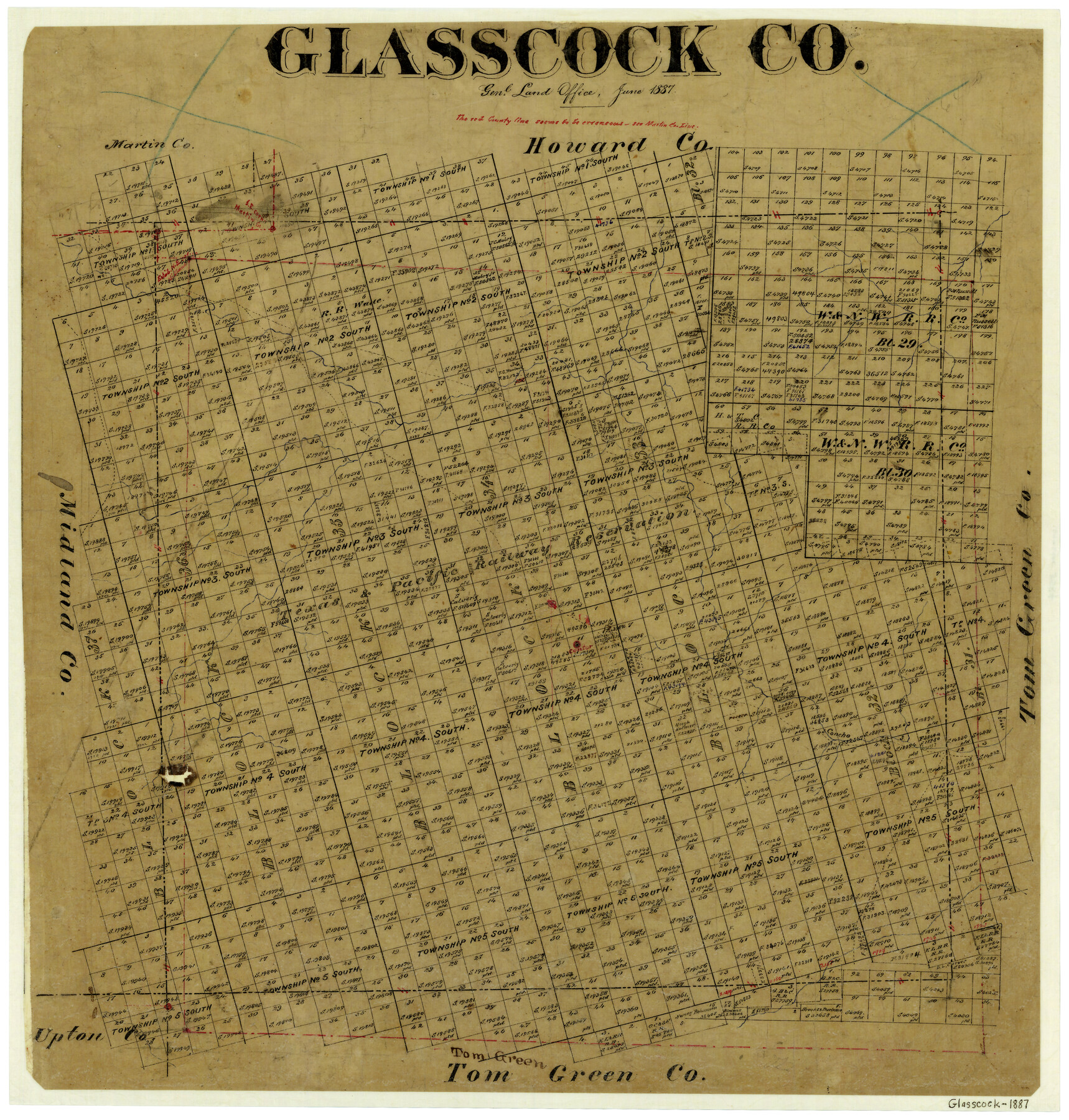
Glasscock County
-
Map/Doc
3584
-
Collection
General Map Collection
-
Object Dates
6/1887 (Creation Date)
-
People and Organizations
Texas General Land Office (Publisher)
-
Counties
Glasscock
-
Subjects
County
-
Height x Width
20.5 x 19.5 inches
52.1 x 49.5 cm
-
Features
Concho River
Part of: General Map Collection
Orange County Working Sketch 35

Print $20.00
- Digital $50.00
Orange County Working Sketch 35
1959
Size 28.8 x 25.0 inches
Map/Doc 71367
Erath County Working Sketch 44

Print $20.00
- Digital $50.00
Erath County Working Sketch 44
1981
Size 29.7 x 30.4 inches
Map/Doc 69125
Frio County Working Sketch 28

Print $20.00
- Digital $50.00
Frio County Working Sketch 28
2006
Size 40.8 x 42.0 inches
Map/Doc 83605
Hardeman County Sketch File 12

Print $4.00
- Digital $50.00
Hardeman County Sketch File 12
Size 12.8 x 8.3 inches
Map/Doc 25020
Anderson County Sketch File 20

Print $6.00
- Digital $50.00
Anderson County Sketch File 20
1852
Size 8.6 x 6.5 inches
Map/Doc 12791
Donley County Rolled Sketch 3

Print $20.00
- Digital $50.00
Donley County Rolled Sketch 3
1946
Size 15.1 x 21.9 inches
Map/Doc 5729
Hutchinson County Working Sketch 16

Print $20.00
- Digital $50.00
Hutchinson County Working Sketch 16
1953
Size 23.0 x 36.3 inches
Map/Doc 66374
Lamar County Sketch File 12

Print $20.00
- Digital $50.00
Lamar County Sketch File 12
Size 19.5 x 23.3 inches
Map/Doc 11967
Flight Mission No. BRE-1P, Frame 55, Nueces County

Print $20.00
- Digital $50.00
Flight Mission No. BRE-1P, Frame 55, Nueces County
1956
Size 18.3 x 22.2 inches
Map/Doc 86644
Webb County Working Sketch 83

Print $20.00
- Digital $50.00
Webb County Working Sketch 83
1980
Size 20.7 x 34.9 inches
Map/Doc 72450
Kimble County Working Sketch 87

Print $20.00
- Digital $50.00
Kimble County Working Sketch 87
1974
Size 24.1 x 30.0 inches
Map/Doc 70155
El Paso County Sketch File 28

Print $18.00
- Digital $50.00
El Paso County Sketch File 28
1939
Size 15.2 x 9.5 inches
Map/Doc 22070
You may also like
[Sketch showing Blocks A, S4, O6, JK, O5, O2, O, JK4, JD, A2, A1]
![89713, [Sketch showing Blocks A, S4, O6, JK, O5, O2, O, JK4, JD, A2, A1], Twichell Survey Records](https://historictexasmaps.com/wmedia_w700/maps/89713-1.tif.jpg)
Print $40.00
- Digital $50.00
[Sketch showing Blocks A, S4, O6, JK, O5, O2, O, JK4, JD, A2, A1]
Size 48.9 x 37.6 inches
Map/Doc 89713
[Township 3 North, Block 32]
![91218, [Township 3 North, Block 32], Twichell Survey Records](https://historictexasmaps.com/wmedia_w700/maps/91218-1.tif.jpg)
Print $20.00
- Digital $50.00
[Township 3 North, Block 32]
Size 14.4 x 17.8 inches
Map/Doc 91218
Flight Mission No. CUG-1P, Frame 82, Kleberg County

Print $20.00
- Digital $50.00
Flight Mission No. CUG-1P, Frame 82, Kleberg County
1956
Size 18.6 x 22.3 inches
Map/Doc 86147
Republic Counties. December 29, 1845

Print $20.00
Republic Counties. December 29, 1845
2020
Size 24.5 x 21.7 inches
Map/Doc 96319
Map of Wyoming Showing Test Wells for Oil and Gas, Anticlinal Axes, Oil and Gas Fields, Pipeline, Unit Areas and Land District Boundaries

Print $40.00
- Digital $50.00
Map of Wyoming Showing Test Wells for Oil and Gas, Anticlinal Axes, Oil and Gas Fields, Pipeline, Unit Areas and Land District Boundaries
1949
Size 55.2 x 42.6 inches
Map/Doc 89886


General Highway Map, Tyler County, Texas

Print $20.00
General Highway Map, Tyler County, Texas
1961
Size 24.8 x 18.1 inches
Map/Doc 79690
Map of Henderson County

Print $20.00
- Digital $50.00
Map of Henderson County
1877
Size 17.7 x 29.2 inches
Map/Doc 3666
Wharton County Working Sketch Graphic Index

Print $20.00
- Digital $50.00
Wharton County Working Sketch Graphic Index
1946
Size 41.7 x 47.5 inches
Map/Doc 76737
Maverick County Rolled Sketch 16

Print $20.00
- Digital $50.00
Maverick County Rolled Sketch 16
1887
Size 21.5 x 31.9 inches
Map/Doc 6709
Polk County Sketch File 1

Print $4.00
- Digital $50.00
Polk County Sketch File 1
Size 13.0 x 7.9 inches
Map/Doc 34116