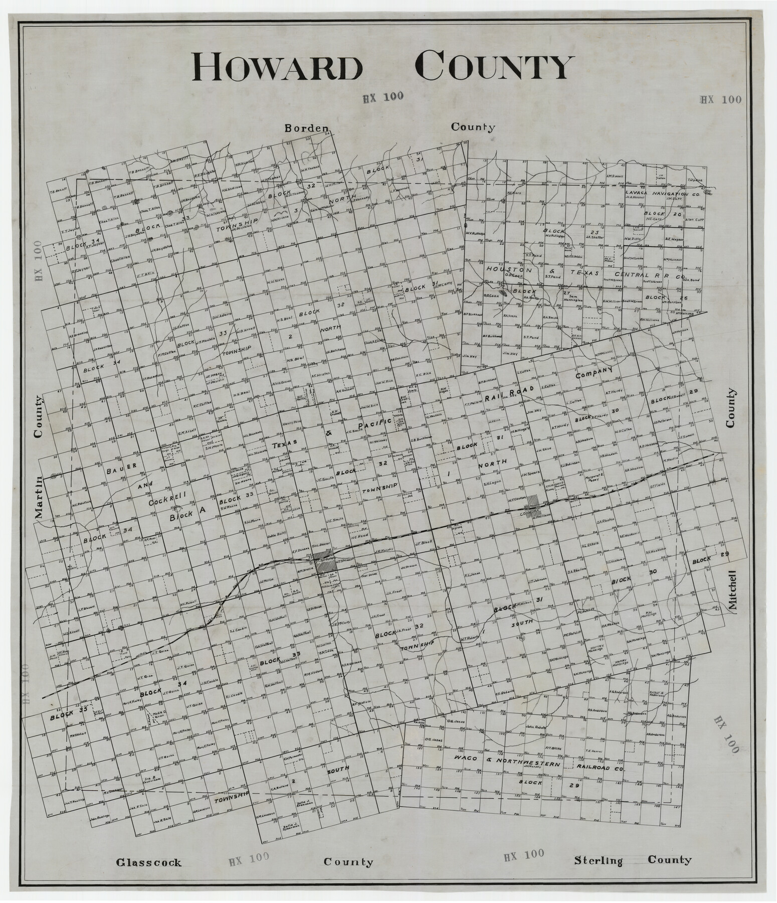
Howard County
HX100
-
Map/Doc
92198
-
Collection
Twichell Survey Records
-
Counties
Howard
-
Subjects
County
-
Height x Width
24.4 x 28.2 inches
62.0 x 71.6 cm
-
Medium
linen
-
Scale
2000'
Part of: Twichell Survey Records
Robertson & Scott V Ranch situated in Crosby County, Texas

Print $40.00
- Digital $50.00
Robertson & Scott V Ranch situated in Crosby County, Texas
Size 41.2 x 48.8 inches
Map/Doc 89758
University of Texas System University Lands

Print $20.00
- Digital $50.00
University of Texas System University Lands
1938
Size 17.9 x 23.5 inches
Map/Doc 93249
Map of State University Land, Pecos County, Texas

Print $20.00
- Digital $50.00
Map of State University Land, Pecos County, Texas
1929
Size 42.1 x 33.5 inches
Map/Doc 91626
[Potter County Blocks 25, P&Mc, O18, G&M2]
![93215, [Potter County Blocks 25, P&Mc, O18, G&M2], Twichell Survey Records](https://historictexasmaps.com/wmedia_w700/maps/93215-1.tif.jpg)
Print $20.00
- Digital $50.00
[Potter County Blocks 25, P&Mc, O18, G&M2]
Size 28.7 x 19.2 inches
Map/Doc 93215
Tom Green County

Print $40.00
- Digital $50.00
Tom Green County
1927
Size 42.5 x 48.3 inches
Map/Doc 93253
Map of Dalhart

Print $20.00
- Digital $50.00
Map of Dalhart
1905
Size 23.5 x 32.0 inches
Map/Doc 92146
C. C. Born Farm South Half Section 91, Block C

Print $20.00
- Digital $50.00
C. C. Born Farm South Half Section 91, Block C
Size 20.5 x 12.9 inches
Map/Doc 92314

[Block M, Block 35, Township 6 North]
![92634, [Block M, Block 35, Township 6 North], Twichell Survey Records](https://historictexasmaps.com/wmedia_w700/maps/92634-1.tif.jpg)
Print $20.00
- Digital $50.00
[Block M, Block 35, Township 6 North]
Size 37.5 x 27.3 inches
Map/Doc 92634
[Ector County Line Descriptions]
![92636, [Ector County Line Descriptions], Twichell Survey Records](https://historictexasmaps.com/wmedia_w700/maps/92636-1.tif.jpg)
Print $20.00
- Digital $50.00
[Ector County Line Descriptions]
Size 37.2 x 44.2 inches
Map/Doc 92636
[Resurvey of Block Number 01- W. H. Godair Surveys]
![92585, [Resurvey of Block Number 01- W. H. Godair Surveys], Twichell Survey Records](https://historictexasmaps.com/wmedia_w700/maps/92585-1.tif.jpg)
Print $20.00
- Digital $50.00
[Resurvey of Block Number 01- W. H. Godair Surveys]
1923
Size 33.9 x 14.9 inches
Map/Doc 92585
Block 39 of the Brown Subdivision being a part of the Northeast Quarter Section 4, Block O

Print $20.00
- Digital $50.00
Block 39 of the Brown Subdivision being a part of the Northeast Quarter Section 4, Block O
1954
Size 14.8 x 14.2 inches
Map/Doc 92822
You may also like
Wichita County Working Sketch 29

Print $20.00
- Digital $50.00
Wichita County Working Sketch 29
2014
Size 16.7 x 20.0 inches
Map/Doc 93688
Plano del Distrilo de Rio Grande Estado de Coahuila

Print $20.00
- Digital $50.00
Plano del Distrilo de Rio Grande Estado de Coahuila
1906
Size 30.3 x 31.5 inches
Map/Doc 1941
Galveston County NRC Article 33.136 Sketch 16

Print $28.00
- Digital $50.00
Galveston County NRC Article 33.136 Sketch 16
2002
Size 25.3 x 36.2 inches
Map/Doc 78314
Comal County State Real Property Sketch 1

Print $134.00
- Digital $50.00
Comal County State Real Property Sketch 1
2006
Size 23.8 x 35.4 inches
Map/Doc 88635
General Highway Map, Fisher County, Texas

Print $20.00
General Highway Map, Fisher County, Texas
1961
Size 18.1 x 24.7 inches
Map/Doc 79466
Hamilton County Sketch File 4

Print $16.00
- Digital $50.00
Hamilton County Sketch File 4
Size 14.5 x 9.1 inches
Map/Doc 24903
Val Verde County Boundary File 103

Print $82.00
- Digital $50.00
Val Verde County Boundary File 103
Size 9.1 x 9.1 inches
Map/Doc 59577
Vehlein and Company Empresario Colony. December 21, 1826

Print $20.00
Vehlein and Company Empresario Colony. December 21, 1826
2020
Size 20.8 x 21.7 inches
Map/Doc 96007
Uvalde County Working Sketch 27

Print $20.00
- Digital $50.00
Uvalde County Working Sketch 27
1957
Size 24.4 x 25.7 inches
Map/Doc 72097
Archer County Rolled Sketch E

Print $20.00
- Digital $50.00
Archer County Rolled Sketch E
Size 34.3 x 37.2 inches
Map/Doc 8424
Burnet County Working Sketch 26

Print $20.00
- Digital $50.00
Burnet County Working Sketch 26
2016
Size 18.7 x 24.8 inches
Map/Doc 93979
Rio Grande, La Grulla Sheet

Print $20.00
- Digital $50.00
Rio Grande, La Grulla Sheet
1931
Size 28.2 x 49.0 inches
Map/Doc 65107