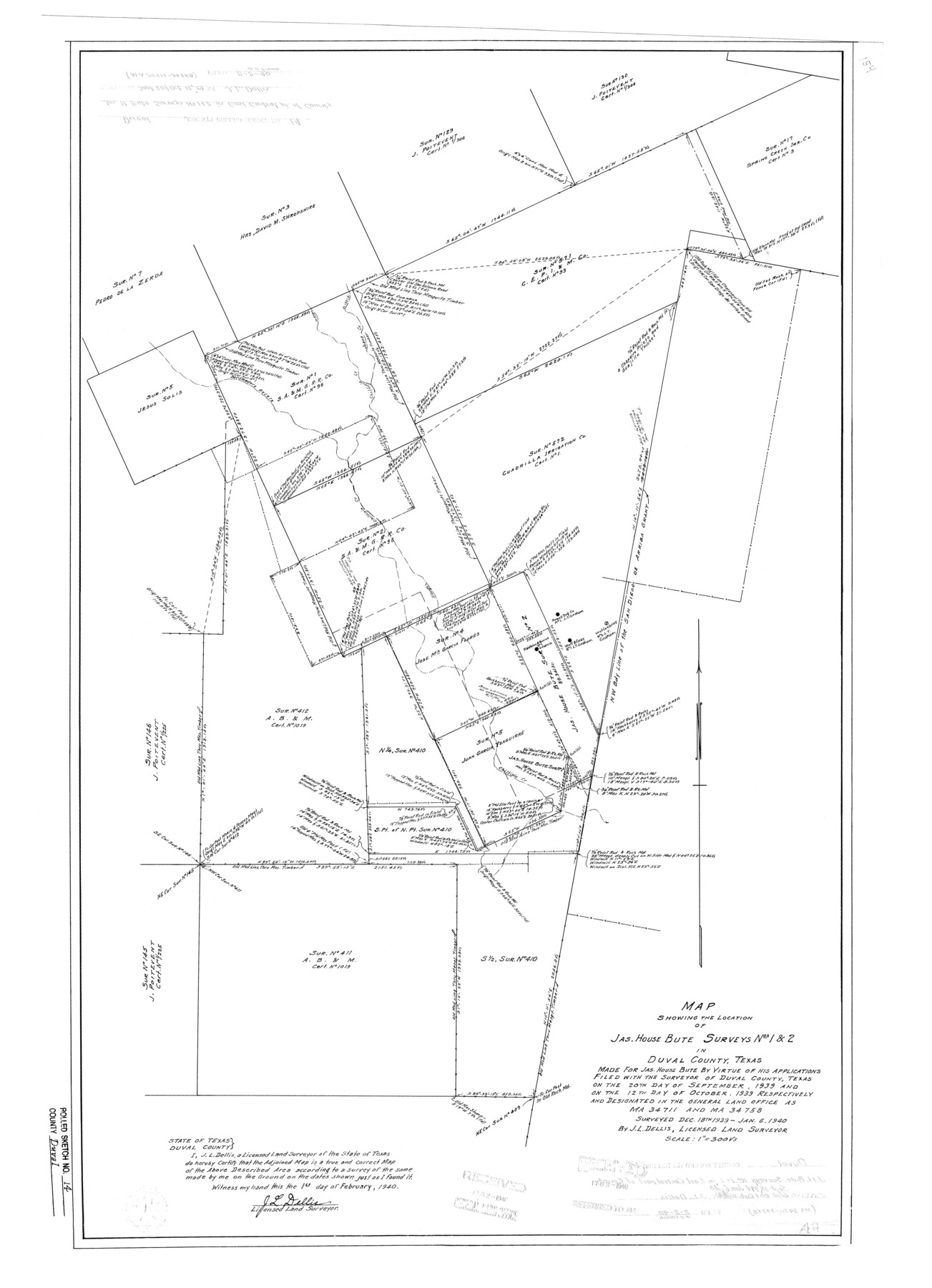
Duval County Rolled Sketch 14
Map showing the location of Jas. House Bute surveys nos. 1 & 2 in Duval County, Texas made for Jas. House Bute by virtue of his applications filed with the surveyor of Duval County
-
Map/Doc
5736
-
Collection
General Map Collection
-
Object Dates
1940/2/1 (Creation Date)
1940/2/2 (File Date)
-
People and Organizations
J.L. Dellis (Surveyor/Engineer)
-
Counties
Duval
-
Subjects
Surveying Rolled Sketch
-
Height x Width
35.8 x 25.9 inches
90.9 x 65.8 cm
-
Scale
1" = 300 varas
-
Comments
See Mineral Applications 34711 and 34758.
Part of: General Map Collection

Rusk County Sketch File 9

Print $4.00
Rusk County Sketch File 9
1849
Size 8.4 x 8.2 inches
Map/Doc 35505
Tarrant County State Real Property Sketch 2

Print $20.00
- Digital $50.00
Tarrant County State Real Property Sketch 2
1994
Size 21.3 x 27.6 inches
Map/Doc 61668
City of Washington

Print $20.00
- Digital $50.00
City of Washington
1846
Size 14.1 x 18.0 inches
Map/Doc 95358
Upton County Working Sketch 49B

Print $20.00
- Digital $50.00
Upton County Working Sketch 49B
1979
Size 19.0 x 32.0 inches
Map/Doc 69546
Hartley County

Print $20.00
- Digital $50.00
Hartley County
1925
Size 34.2 x 41.5 inches
Map/Doc 77306
Zapata County Working Sketch 6

Print $40.00
- Digital $50.00
Zapata County Working Sketch 6
1946
Size 65.9 x 37.0 inches
Map/Doc 62057
Val Verde County Rolled Sketch 33

Print $20.00
- Digital $50.00
Val Verde County Rolled Sketch 33
1891
Size 27.8 x 28.2 inches
Map/Doc 8112
United States - Gulf Coast - From Latitude 26° 33' to the Rio Grande Texas

Print $20.00
- Digital $50.00
United States - Gulf Coast - From Latitude 26° 33' to the Rio Grande Texas
1913
Size 18.3 x 23.6 inches
Map/Doc 72844
Knox County Rolled Sketch 10

Print $40.00
- Digital $50.00
Knox County Rolled Sketch 10
Size 56.6 x 35.6 inches
Map/Doc 10718
Atascosa County

Print $20.00
- Digital $50.00
Atascosa County
1948
Size 47.2 x 46.3 inches
Map/Doc 95421
Starr County Boundary File 1a

Print $20.00
- Digital $50.00
Starr County Boundary File 1a
Size 22.4 x 41.0 inches
Map/Doc 58813
You may also like
Haskell County Working Sketch 8

Print $20.00
- Digital $50.00
Haskell County Working Sketch 8
1957
Size 22.8 x 24.0 inches
Map/Doc 66066
Map of Dallas County

Print $20.00
- Digital $50.00
Map of Dallas County
1871
Size 22.1 x 18.7 inches
Map/Doc 3463
Bailey County Working Sketch 2

Print $20.00
- Digital $50.00
Bailey County Working Sketch 2
1920
Size 17.8 x 16.2 inches
Map/Doc 67589
Val Verde County Working Sketch 3

Print $20.00
- Digital $50.00
Val Verde County Working Sketch 3
Size 17.5 x 24.1 inches
Map/Doc 72138
[Leagues 622, 621]
![92170, [Leagues 622, 621], Twichell Survey Records](https://historictexasmaps.com/wmedia_w700/maps/92170-1.tif.jpg)
Print $20.00
- Digital $50.00
[Leagues 622, 621]
Size 24.2 x 19.8 inches
Map/Doc 92170
[Sketch showing A. B. & M. Block 2]
![91701, [Sketch showing A. B. & M. Block 2], Twichell Survey Records](https://historictexasmaps.com/wmedia_w700/maps/91701-1.tif.jpg)
Print $2.00
- Digital $50.00
[Sketch showing A. B. & M. Block 2]
Size 7.5 x 5.8 inches
Map/Doc 91701
Ellis County Sketch File 17

Print $40.00
- Digital $50.00
Ellis County Sketch File 17
1861
Size 12.9 x 16.1 inches
Map/Doc 21860
Lampasas County Boundary File 3a

Print $8.00
- Digital $50.00
Lampasas County Boundary File 3a
Size 13.2 x 8.2 inches
Map/Doc 56106
Plan C, Part 1st Shewing that portion of the boundary between Texas and the United States, included between the intersection of the 32nd degree of Latitude with western bank of Sabine River and the 36th mile mound

Print $20.00
- Digital $50.00
Plan C, Part 1st Shewing that portion of the boundary between Texas and the United States, included between the intersection of the 32nd degree of Latitude with western bank of Sabine River and the 36th mile mound
1842
Size 19.4 x 27.7 inches
Map/Doc 65412
[Office Sketch Showing Surveys North of Loma Blanca Grant, Brooks County, Texas]
![412, [Office Sketch Showing Surveys North of Loma Blanca Grant, Brooks County, Texas], Maddox Collection](https://historictexasmaps.com/wmedia_w700/maps/0412.tif.jpg)
Print $20.00
- Digital $50.00
[Office Sketch Showing Surveys North of Loma Blanca Grant, Brooks County, Texas]
Size 16.6 x 19.6 inches
Map/Doc 412
Atascosa County Rolled Sketch 5A

Print $20.00
- Digital $50.00
Atascosa County Rolled Sketch 5A
1910
Size 20.8 x 14.4 inches
Map/Doc 5089
Morris County Rolled Sketch 2A

Print $3.00
- Digital $50.00
Morris County Rolled Sketch 2A
Size 12.1 x 10.5 inches
Map/Doc 10233