Denton County Rolled Sketch 6
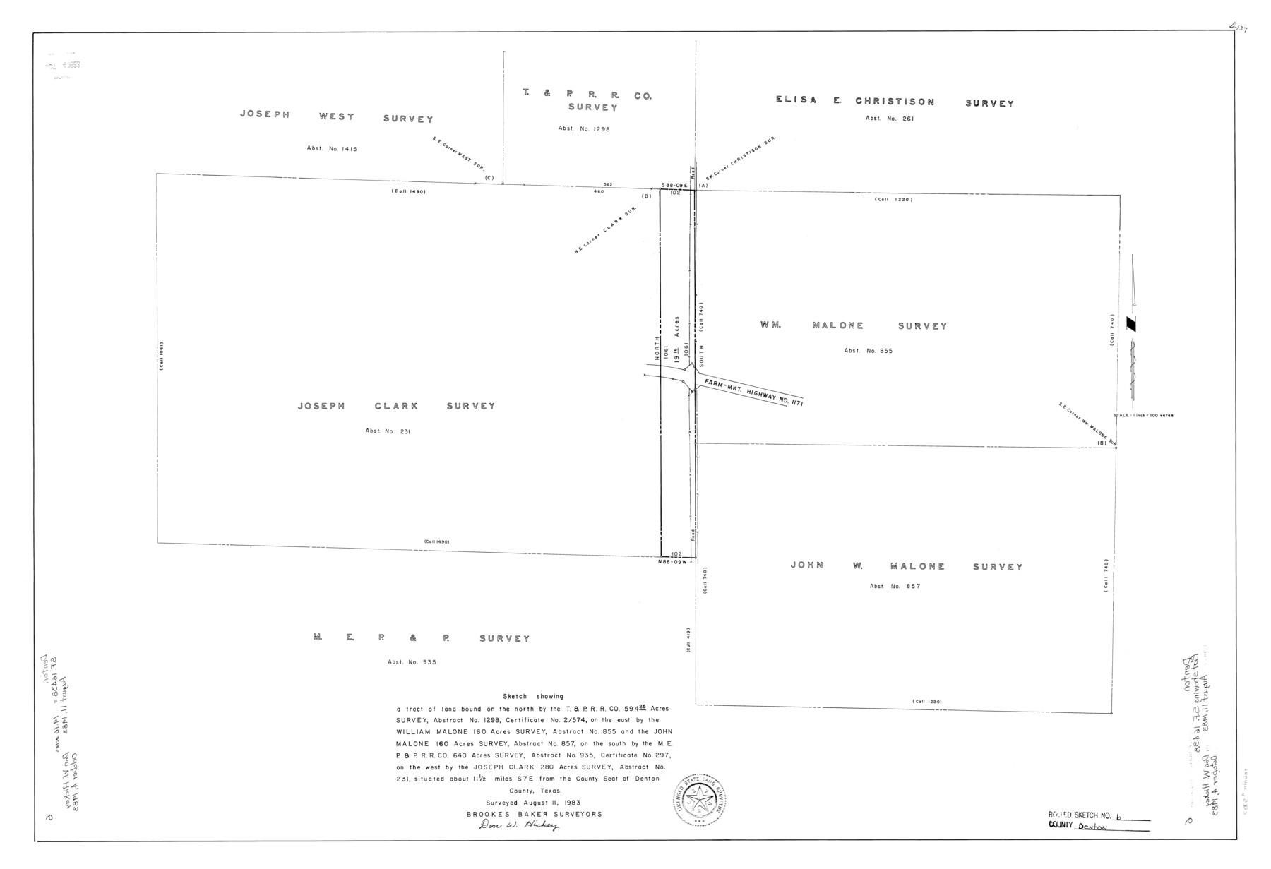
Sketch showing a tract of land [bound on the north by A-1298, on the east by A-855 and A-857, on the south by A-935 and on the west by A-231]
-
Map/Doc
5702
-
Collection
General Map Collection
-
Object Dates
1983/8/11 (Creation Date)
1983/10/4 (File Date)
-
People and Organizations
Don W. Hickey (Surveyor/Engineer)
-
Counties
Denton
-
Subjects
Surveying Rolled Sketch
-
Height x Width
25.4 x 37.2 inches
64.5 x 94.5 cm
-
Scale
1" = 100 varas
Part of: General Map Collection
Culberson County Sketch File 3b

Print $20.00
- Digital $50.00
Culberson County Sketch File 3b
1880
Size 20.3 x 28.0 inches
Map/Doc 11262
Houston County Working Sketch 32

Print $20.00
- Digital $50.00
Houston County Working Sketch 32
1987
Size 43.9 x 33.0 inches
Map/Doc 66262
Navigation Maps of Gulf Intracoastal Waterway, Port Arthur to Brownsville, Texas

Print $4.00
- Digital $50.00
Navigation Maps of Gulf Intracoastal Waterway, Port Arthur to Brownsville, Texas
1951
Size 16.7 x 21.5 inches
Map/Doc 65424
Map of Fannin County

Print $20.00
- Digital $50.00
Map of Fannin County
1845
Size 34.7 x 36.5 inches
Map/Doc 16827
Cass County Sketch File 24

Print $16.00
- Digital $50.00
Cass County Sketch File 24
1936
Size 13.9 x 8.7 inches
Map/Doc 17436
Cherokee County Working Sketch 20

Print $40.00
- Digital $50.00
Cherokee County Working Sketch 20
1967
Size 37.6 x 61.1 inches
Map/Doc 67975
Montgomery County Rolled Sketch 19A

Print $40.00
- Digital $50.00
Montgomery County Rolled Sketch 19A
1933
Size 52.9 x 37.3 inches
Map/Doc 8349
National Map Company's Map of Texas showing counties, cities, towns, villages and post offices, steam and electric railways with stations and distance between stations

Print $40.00
- Digital $50.00
National Map Company's Map of Texas showing counties, cities, towns, villages and post offices, steam and electric railways with stations and distance between stations
1920
Size 49.1 x 50.3 inches
Map/Doc 10750
McCulloch County Working Sketch 5

Print $20.00
- Digital $50.00
McCulloch County Working Sketch 5
1961
Size 21.3 x 19.2 inches
Map/Doc 70680
Carson County Boundary File 3

Print $2.00
- Digital $50.00
Carson County Boundary File 3
Size 13.3 x 8.3 inches
Map/Doc 51131
Lampasas County Sketch File 7a

Print $4.00
- Digital $50.00
Lampasas County Sketch File 7a
1854
Size 12.4 x 8.2 inches
Map/Doc 29404
Concho County Working Sketch 5

Print $20.00
- Digital $50.00
Concho County Working Sketch 5
1948
Size 41.3 x 37.9 inches
Map/Doc 68187
You may also like
Sherman County Rolled Sketch 4

Print $20.00
- Digital $50.00
Sherman County Rolled Sketch 4
Size 23.1 x 31.7 inches
Map/Doc 7786
Harris County Rolled Sketch T1

Print $20.00
- Digital $50.00
Harris County Rolled Sketch T1
1916
Size 29.8 x 24.3 inches
Map/Doc 6144
[Map of Coahuila and Nuevo Leon]
![97128, [Map of Coahuila and Nuevo Leon], General Map Collection](https://historictexasmaps.com/wmedia_w700/maps/97128.tif.jpg)
Print $20.00
- Digital $50.00
[Map of Coahuila and Nuevo Leon]
1873
Size 16.8 x 11.6 inches
Map/Doc 97128
Dallas County Boundary File 6e

Print $70.00
- Digital $50.00
Dallas County Boundary File 6e
Size 16.6 x 22.5 inches
Map/Doc 52254
La Salle County Sketch File 4

Print $22.00
- Digital $50.00
La Salle County Sketch File 4
Size 12.7 x 16.2 inches
Map/Doc 29450
[Portion of a sketch showing S.F. 7265]
![90386, [Portion of a sketch showing S.F. 7265], Twichell Survey Records](https://historictexasmaps.com/wmedia_w700/maps/90386-1.tif.jpg)
Print $2.00
- Digital $50.00
[Portion of a sketch showing S.F. 7265]
Size 13.3 x 9.1 inches
Map/Doc 90386

Montague County Working Sketch 21

Print $20.00
- Digital $50.00
Montague County Working Sketch 21
1952
Size 33.1 x 39.5 inches
Map/Doc 71087
Hall County Boundary File 2

Print $12.00
- Digital $50.00
Hall County Boundary File 2
Size 11.1 x 8.6 inches
Map/Doc 54177
Culberson County Rolled Sketch 27

Print $20.00
- Digital $50.00
Culberson County Rolled Sketch 27
1922
Size 26.8 x 34.9 inches
Map/Doc 5656
Archer County Working Sketch 9

Print $20.00
- Digital $50.00
Archer County Working Sketch 9
1924
Size 22.2 x 29.8 inches
Map/Doc 67149
Upton County Boundary File 1b

Print $28.00
- Digital $50.00
Upton County Boundary File 1b
Size 13.5 x 9.1 inches
Map/Doc 59512