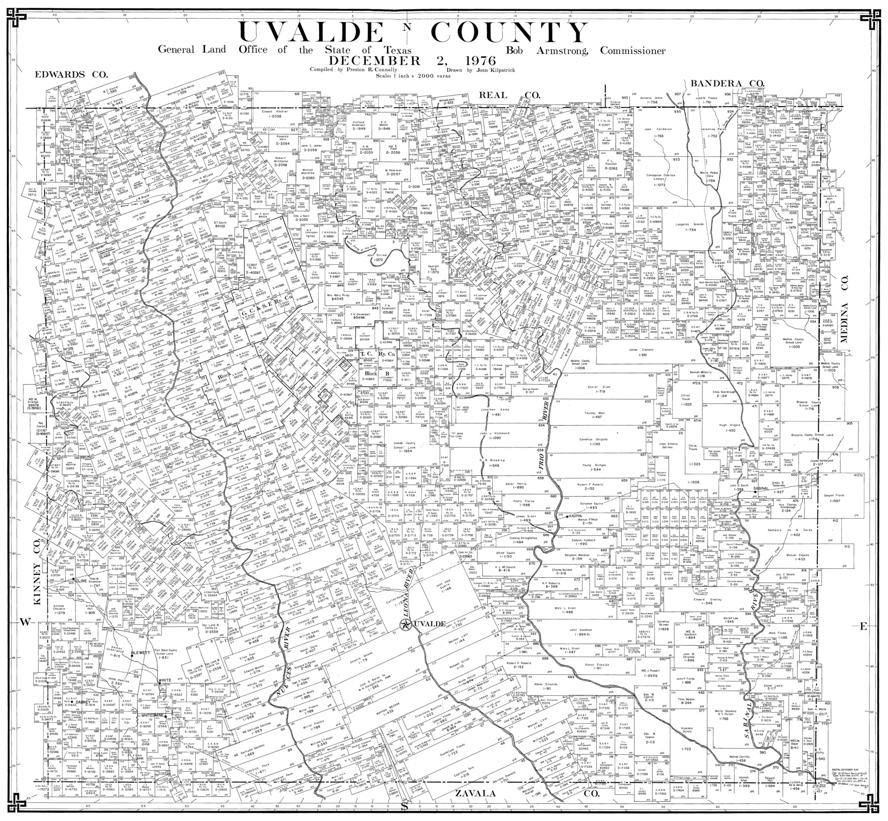
Uvalde County
-
Map/Doc
77444
-
Collection
General Map Collection
-
Object Dates
12/2/1976 (Creation Date)
-
People and Organizations
Preston R. Connally (Compiler)
Joan Kilpatrick (Draftsman)
-
Counties
Uvalde
-
Subjects
County
-
Height x Width
42.0 x 45.4 inches
106.7 x 115.3 cm
-
Scale
1" = 2000 varas
Part of: General Map Collection
Texas Panhandle East Boundary Line

Print $20.00
- Digital $50.00
Texas Panhandle East Boundary Line
1898
Size 32.1 x 8.8 inches
Map/Doc 1700
Smith County Sketch File 19

Print $42.00
- Digital $50.00
Smith County Sketch File 19
1850
Size 8.1 x 13.0 inches
Map/Doc 36794
Kimble County Rolled Sketch 28

Print $20.00
- Digital $50.00
Kimble County Rolled Sketch 28
1964
Size 19.7 x 20.6 inches
Map/Doc 6518
Flight Mission No. DCL-5C, Frame 66, Kenedy County

Print $20.00
- Digital $50.00
Flight Mission No. DCL-5C, Frame 66, Kenedy County
1943
Size 18.4 x 22.3 inches
Map/Doc 85849
Jackson County Sketch File 17

Print $20.00
- Digital $50.00
Jackson County Sketch File 17
1913
Size 19.4 x 19.1 inches
Map/Doc 11841
Colorado County Working Sketch 26

Print $20.00
- Digital $50.00
Colorado County Working Sketch 26
1977
Size 22.7 x 18.7 inches
Map/Doc 68126
Medina County

Print $40.00
- Digital $50.00
Medina County
1915
Size 53.2 x 44.8 inches
Map/Doc 10790
Right of Way and Track Map of The Wichita Falls & Southern Railroad Company

Print $40.00
- Digital $50.00
Right of Way and Track Map of The Wichita Falls & Southern Railroad Company
1942
Size 24.4 x 56.4 inches
Map/Doc 64515
Webb County Working Sketch 66

Print $40.00
- Digital $50.00
Webb County Working Sketch 66
1966
Size 62.8 x 42.5 inches
Map/Doc 72433
Panola County Working Sketch 21

Print $20.00
- Digital $50.00
Panola County Working Sketch 21
1947
Map/Doc 71430
Wilbarger County Sketch File 28

Print $20.00
- Digital $50.00
Wilbarger County Sketch File 28
2016
Size 23.9 x 36.2 inches
Map/Doc 95324

You may also like
Map of Falls County

Print $20.00
- Digital $50.00
Map of Falls County
1874
Size 19.8 x 22.6 inches
Map/Doc 3530
[Blocks WJG2, FR, 330]
![92330, [Blocks WJG2, FR, 330], Twichell Survey Records](https://historictexasmaps.com/wmedia_w700/maps/92330-1.tif.jpg)
Print $20.00
- Digital $50.00
[Blocks WJG2, FR, 330]
Size 25.8 x 25.8 inches
Map/Doc 92330
Edwards County Sketch File 51

Print $32.00
- Digital $50.00
Edwards County Sketch File 51
1965
Size 11.6 x 9.0 inches
Map/Doc 21800
Montgomery County Working Sketch 5

Print $20.00
- Digital $50.00
Montgomery County Working Sketch 5
1932
Size 31.6 x 37.0 inches
Map/Doc 71111
San Jacinto County Rolled Sketch 6

Print $20.00
- Digital $50.00
San Jacinto County Rolled Sketch 6
Size 42.1 x 43.5 inches
Map/Doc 8361
Map Showing Jacob Kuechler's Meander of West Bank of Pecos River in December 1876

Print $20.00
- Digital $50.00
Map Showing Jacob Kuechler's Meander of West Bank of Pecos River in December 1876
Size 18.6 x 17.4 inches
Map/Doc 91669
PSL Field Notes for Blocks 58, 59, 60 1/2, 61 1/2, 62 1/2, 63 1/2, 64 1/2, 65 1/2, 66 1/2, 67 1/2, 68 1/2, 69 1/2, 70, 71, and 72 in Hudspeth County

PSL Field Notes for Blocks 58, 59, 60 1/2, 61 1/2, 62 1/2, 63 1/2, 64 1/2, 65 1/2, 66 1/2, 67 1/2, 68 1/2, 69 1/2, 70, 71, and 72 in Hudspeth County
Map/Doc 81662
Culberson County Working Sketch 39

Print $40.00
- Digital $50.00
Culberson County Working Sketch 39
1966
Size 37.9 x 82.7 inches
Map/Doc 68492
General Highway Map, Throckmorton County, Texas

Print $20.00
General Highway Map, Throckmorton County, Texas
1961
Size 18.2 x 24.8 inches
Map/Doc 79676

Flight Mission No. BRA-3M, Frame 192, Jefferson County

Print $20.00
- Digital $50.00
Flight Mission No. BRA-3M, Frame 192, Jefferson County
1953
Size 18.5 x 22.4 inches
Map/Doc 85407
Flight Mission No. CLL-1N, Frame 102, Willacy County

Print $20.00
- Digital $50.00
Flight Mission No. CLL-1N, Frame 102, Willacy County
1954
Size 18.3 x 22.0 inches
Map/Doc 87036