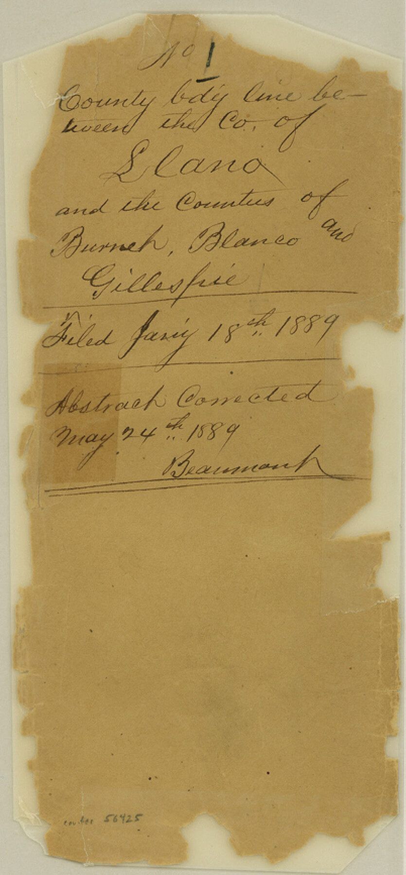
Llano County Boundary File 1
County bd'y line between the Co. of Llano and the Counties of Burnet, Blanco and Gillespie
-
Map/Doc
56425
-
Collection
General Map Collection
-
Counties
Llano
-
Subjects
County Boundaries
-
Height x Width
8.7 x 4.0 inches
22.1 x 10.2 cm
Part of: General Map Collection
Montague County Sketch File 7

Print $6.00
- Digital $50.00
Montague County Sketch File 7
1860
Size 6.3 x 5.4 inches
Map/Doc 31719
Freestone County Sketch File 7

Print $4.00
- Digital $50.00
Freestone County Sketch File 7
1861
Size 14.4 x 8.3 inches
Map/Doc 23052
Comanche County Boundary File 21

Print $10.00
- Digital $50.00
Comanche County Boundary File 21
Size 8.3 x 3.7 inches
Map/Doc 51800
Chambers County Sketch File 49

Print $26.00
- Digital $50.00
Chambers County Sketch File 49
Size 14.3 x 8.9 inches
Map/Doc 18045
Map of the Surveyed Part of Young District

Print $40.00
- Digital $50.00
Map of the Surveyed Part of Young District
1860
Size 56.3 x 27.3 inches
Map/Doc 87374
Rusk County Working Sketch 16

Print $20.00
- Digital $50.00
Rusk County Working Sketch 16
1956
Size 32.1 x 42.7 inches
Map/Doc 63651
Bexar County Sketch File 3

Print $4.00
- Digital $50.00
Bexar County Sketch File 3
Size 12.8 x 8.3 inches
Map/Doc 14473
Knox County Working Sketch 13

Print $3.00
- Digital $50.00
Knox County Working Sketch 13
1953
Size 9.6 x 11.0 inches
Map/Doc 70255
Matagorda County Rolled Sketch 39

Print $40.00
- Digital $50.00
Matagorda County Rolled Sketch 39
1973
Size 24.4 x 114.0 inches
Map/Doc 10743
Parker County Sketch File 41

Print $4.00
- Digital $50.00
Parker County Sketch File 41
1877
Size 8.9 x 10.6 inches
Map/Doc 33587
Wheeler County Working Sketch 7

Print $40.00
- Digital $50.00
Wheeler County Working Sketch 7
1972
Size 50.1 x 42.9 inches
Map/Doc 72496
Texas Coordinate File 5

Print $4.00
- Digital $50.00
Texas Coordinate File 5
Size 11.2 x 8.7 inches
Map/Doc 75312
You may also like
McMullen County Sketch File 32-33

Print $16.00
- Digital $50.00
McMullen County Sketch File 32-33
1875
Size 10.1 x 8.0 inches
Map/Doc 31392
Van Zandt County

Print $20.00
- Digital $50.00
Van Zandt County
1870
Size 22.9 x 21.6 inches
Map/Doc 4637
Stonewall County Rolled Sketch 18

Print $20.00
- Digital $50.00
Stonewall County Rolled Sketch 18
1950
Size 27.4 x 29.4 inches
Map/Doc 7872
Jefferson County Rolled Sketch 57

Print $20.00
- Digital $50.00
Jefferson County Rolled Sketch 57
1883
Size 18.6 x 25.9 inches
Map/Doc 6409
Flight Mission No. BQR-4K, Frame 63, Brazoria County

Print $20.00
- Digital $50.00
Flight Mission No. BQR-4K, Frame 63, Brazoria County
1952
Size 18.9 x 22.5 inches
Map/Doc 83996
Bandera County Working Sketch 59

Print $20.00
- Digital $50.00
Bandera County Working Sketch 59
2003
Size 41.1 x 33.9 inches
Map/Doc 78346
Map of parts of Presidio, Brewster and Foley Counties

Print $20.00
Map of parts of Presidio, Brewster and Foley Counties
1891
Size 22.5 x 17.5 inches
Map/Doc 88987
Milam County Sketch File 2

Print $4.00
- Digital $50.00
Milam County Sketch File 2
1849
Size 8.0 x 12.4 inches
Map/Doc 31627
[Blocks D3, A, D7, and RG]
![92764, [Blocks D3, A, D7, and RG], Twichell Survey Records](https://historictexasmaps.com/wmedia_w700/maps/92764-1.tif.jpg)
Print $20.00
- Digital $50.00
[Blocks D3, A, D7, and RG]
Size 36.7 x 31.1 inches
Map/Doc 92764
Map Showing Colonel A.W. Doniphan's Route through the States of New Mexico, Chihuahua and Coahuila

Print $20.00
Map Showing Colonel A.W. Doniphan's Route through the States of New Mexico, Chihuahua and Coahuila
1847
Size 16.9 x 14.0 inches
Map/Doc 79729
Flight Mission No. CGI-4N, Frame 192, Cameron County

Print $20.00
- Digital $50.00
Flight Mission No. CGI-4N, Frame 192, Cameron County
1955
Size 18.6 x 22.2 inches
Map/Doc 84695
Map of Texas with population and location of principal towns and cities according to latest reliable statistics

Print $20.00
- Digital $50.00
Map of Texas with population and location of principal towns and cities according to latest reliable statistics
1921
Size 18.1 x 21.5 inches
Map/Doc 95880