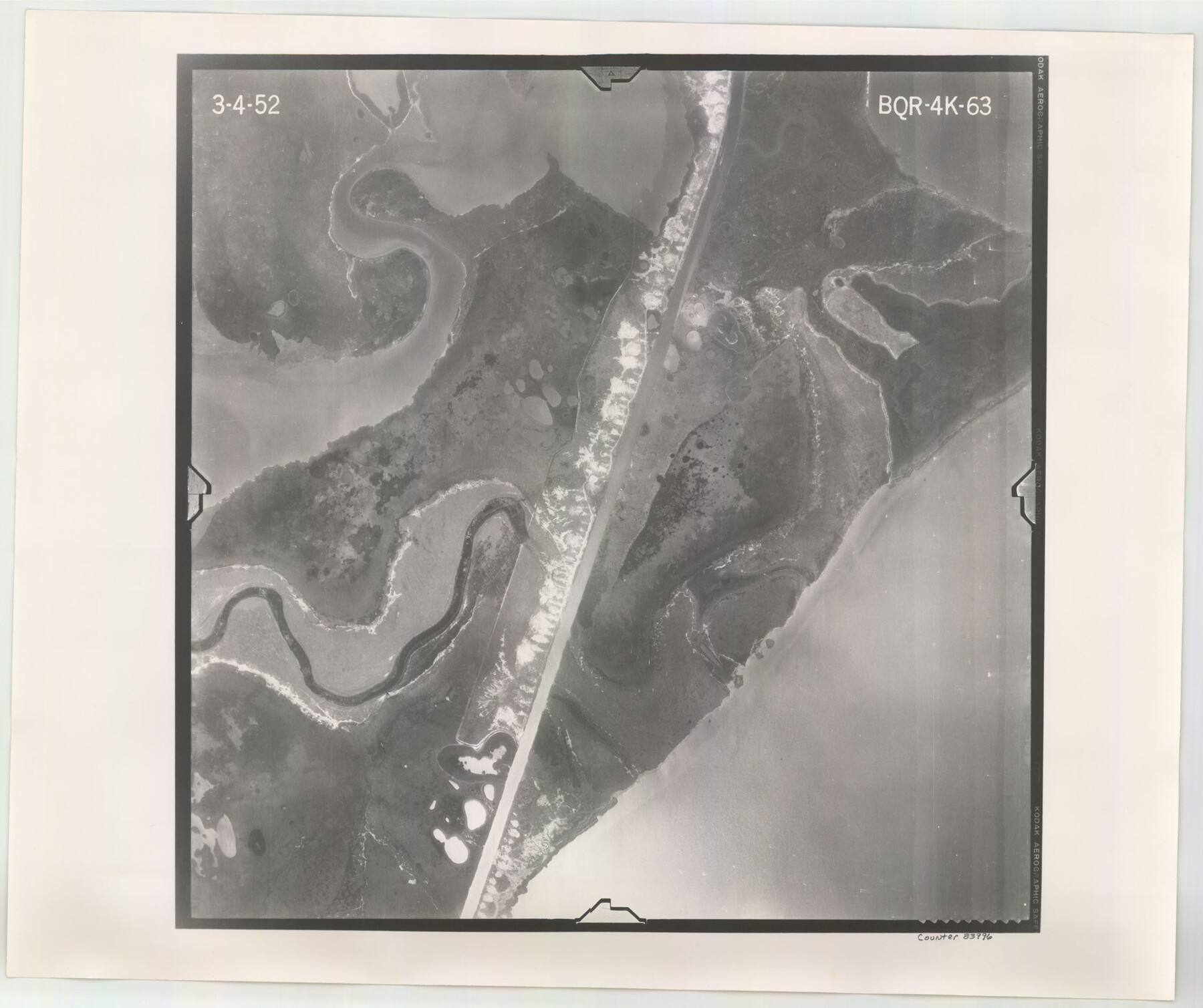
Flight Mission No. BQR-4K, Frame 63, Brazoria County
BQR-4K-63
-
Map/Doc
83996
-
Collection
General Map Collection
-
Object Dates
1952/3/4 (Creation Date)
-
People and Organizations
U. S. Department of Agriculture (Publisher)
-
Counties
Brazoria
-
Subjects
Aerial Photograph
-
Height x Width
18.9 x 22.5 inches
48.0 x 57.2 cm
-
Comments
Flown by Aero Exploration Company of Tulsa, Oklahoma.
Part of: General Map Collection
Hays County Working Sketch 19

Print $20.00
- Digital $50.00
Hays County Working Sketch 19
1980
Size 30.1 x 26.0 inches
Map/Doc 66093
Kenedy County Rolled Sketch 18

Print $20.00
- Digital $50.00
Kenedy County Rolled Sketch 18
1995
Size 29.5 x 39.2 inches
Map/Doc 6472
Trails made and routes used by the Fourth U.S. Cavalry under command of General R.S. Mackenzie in its operations against hostile indians in Texas, Indian-Territory (now Oklahoma), New Mexico and Old Mexico during the period of 1871-2-3-4 and 5

Print $20.00
- Digital $50.00
Trails made and routes used by the Fourth U.S. Cavalry under command of General R.S. Mackenzie in its operations against hostile indians in Texas, Indian-Territory (now Oklahoma), New Mexico and Old Mexico during the period of 1871-2-3-4 and 5
1927
Size 37.0 x 34.2 inches
Map/Doc 62973
Crane County Rolled Sketch 28

Print $40.00
- Digital $50.00
Crane County Rolled Sketch 28
2020
Size 35.7 x 51.2 inches
Map/Doc 96434
Jones County Rolled Sketch 4

Print $20.00
- Digital $50.00
Jones County Rolled Sketch 4
2022
Size 31.9 x 24.0 inches
Map/Doc 97150
Brazoria County Working Sketch 20

Print $40.00
- Digital $50.00
Brazoria County Working Sketch 20
1951
Size 50.3 x 42.9 inches
Map/Doc 67505
Texas Coordinate File 6

Print $40.00
- Digital $50.00
Texas Coordinate File 6
1946
Size 23.7 x 49.0 inches
Map/Doc 75314
Moore County Working Sketch 14

Print $20.00
- Digital $50.00
Moore County Working Sketch 14
1972
Size 32.7 x 19.8 inches
Map/Doc 71196
[Surveys in Polk and Chambers Counties]
![355, [Surveys in Polk and Chambers Counties], General Map Collection](https://historictexasmaps.com/wmedia_w700/maps/355.tif.jpg)
Print $3.00
- Digital $50.00
[Surveys in Polk and Chambers Counties]
Size 11.7 x 14.4 inches
Map/Doc 355
Brewster County Sketch File N-11

Print $40.00
- Digital $50.00
Brewster County Sketch File N-11
Size 23.2 x 9.5 inches
Map/Doc 10965
Reeves County Rolled Sketch 33

Print $20.00
- Digital $50.00
Reeves County Rolled Sketch 33
Size 24.9 x 36.8 inches
Map/Doc 7503
Flight Mission No. DQN-5K, Frame 145, Calhoun County

Print $20.00
- Digital $50.00
Flight Mission No. DQN-5K, Frame 145, Calhoun County
1953
Size 18.5 x 22.1 inches
Map/Doc 84420
You may also like
Karte des Staates, Texas

Print $20.00
Karte des Staates, Texas
1851
Size 27.2 x 30.1 inches
Map/Doc 76262
Chambers County Working Sketch 21

Print $20.00
- Digital $50.00
Chambers County Working Sketch 21
1974
Size 44.1 x 34.8 inches
Map/Doc 68004
Map of Walker County

Print $20.00
- Digital $50.00
Map of Walker County
1858
Size 22.9 x 34.1 inches
Map/Doc 4120
Hill County Sketch File 16

Print $4.00
- Digital $50.00
Hill County Sketch File 16
1860
Size 9.9 x 8.3 inches
Map/Doc 26482
Tom Green County Sketch File 2

Print $4.00
- Digital $50.00
Tom Green County Sketch File 2
Size 9.6 x 7.6 inches
Map/Doc 38161
Taylor County Working Sketch 16

Print $20.00
- Digital $50.00
Taylor County Working Sketch 16
1981
Size 28.8 x 41.2 inches
Map/Doc 69626
San Jacinto County Working Sketch 15

Print $20.00
- Digital $50.00
San Jacinto County Working Sketch 15
1935
Size 32.0 x 36.5 inches
Map/Doc 63728
Tarrant's Key and Guide to Dallas

Print $3.00
- Digital $50.00
Tarrant's Key and Guide to Dallas
1922
Size 7.9 x 10.4 inches
Map/Doc 89257
Harris County Working Sketch 84

Print $20.00
- Digital $50.00
Harris County Working Sketch 84
1970
Size 36.2 x 33.7 inches
Map/Doc 65976
Pecos County Rolled Sketch 72

Print $30.00
- Digital $50.00
Pecos County Rolled Sketch 72
1934
Size 35.8 x 45.1 inches
Map/Doc 9704
Foard County Sketch File X1

Print $40.00
- Digital $50.00
Foard County Sketch File X1
Size 17.6 x 14.2 inches
Map/Doc 22800
A Few Things About Rice as grown on line of Southern Pacific in Texas and Louisiana

A Few Things About Rice as grown on line of Southern Pacific in Texas and Louisiana
1904
Map/Doc 96723