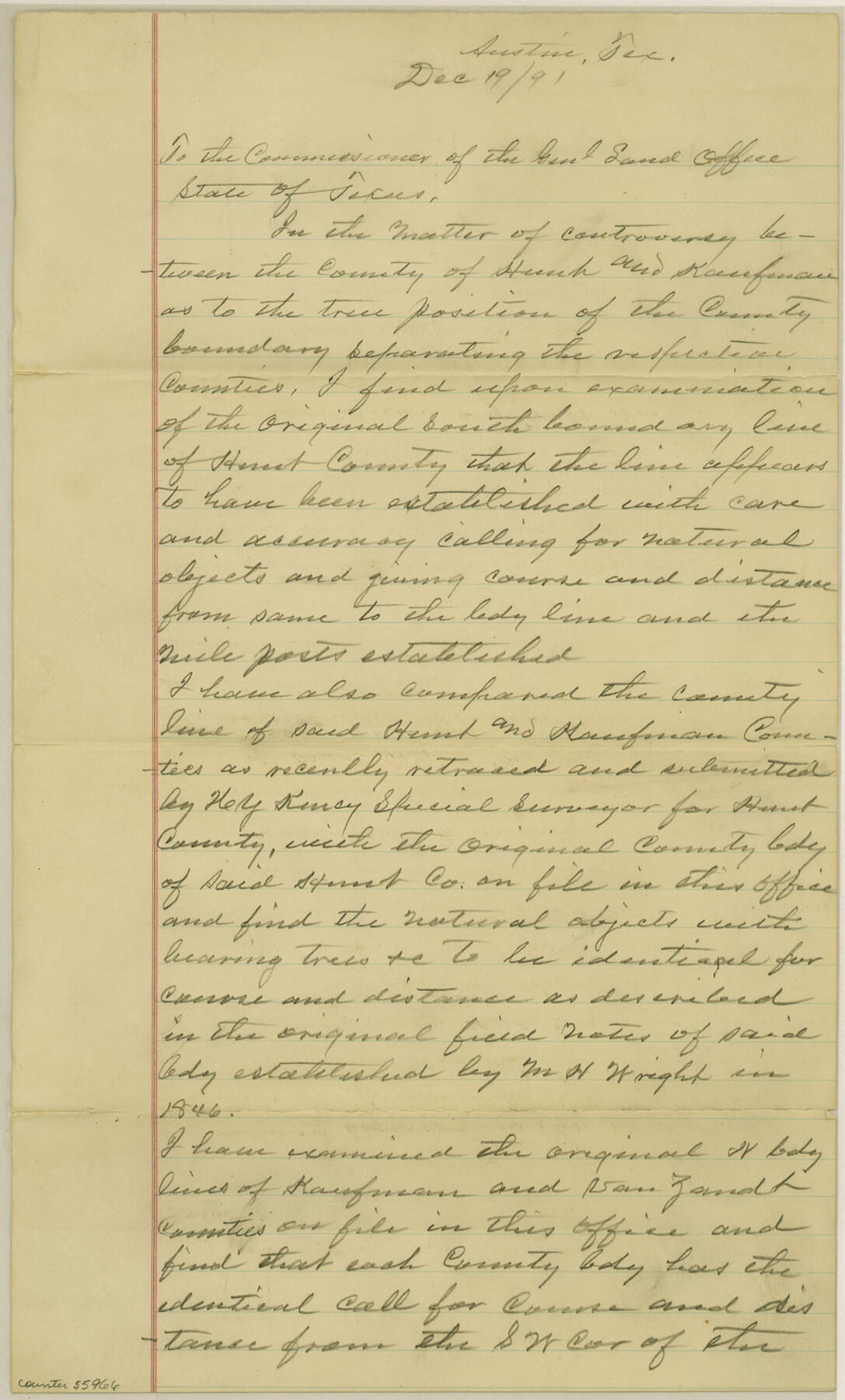
Kaufman County Boundary File 6b
[Draftsman's Statement]
-
Map/Doc
55966
-
Collection
General Map Collection
-
Counties
Kaufman
-
Subjects
County Boundaries
-
Height x Width
14.2 x 8.5 inches
36.1 x 21.6 cm
Part of: General Map Collection
McCulloch County Boundary File 3

Print $16.00
- Digital $50.00
McCulloch County Boundary File 3
Size 11.1 x 8.6 inches
Map/Doc 56911
Yoakum County Sketch File 15

Print $22.00
- Digital $50.00
Yoakum County Sketch File 15
1938
Size 18.0 x 8.8 inches
Map/Doc 40793
Ramsey State Farm of the Texas Prison System, Brazoria County

Print $4.00
- Digital $50.00
Ramsey State Farm of the Texas Prison System, Brazoria County
1932
Size 15.9 x 18.6 inches
Map/Doc 65273
Palo Pinto County Working Sketch 14

Print $20.00
- Digital $50.00
Palo Pinto County Working Sketch 14
1960
Size 27.2 x 27.4 inches
Map/Doc 71397
Upton County Working Sketch 29

Print $40.00
- Digital $50.00
Upton County Working Sketch 29
1956
Size 50.6 x 36.0 inches
Map/Doc 69525
Flight Mission No. CUG-3P, Frame 30, Kleberg County

Print $20.00
- Digital $50.00
Flight Mission No. CUG-3P, Frame 30, Kleberg County
1956
Size 18.5 x 22.2 inches
Map/Doc 86235
Bell County Sketch File 24

Print $4.00
- Digital $50.00
Bell County Sketch File 24
Size 10.0 x 8.0 inches
Map/Doc 14418
[Surveys in Polk and Tyler Counties, Liberty District]
![354, [Surveys in Polk and Tyler Counties, Liberty District], General Map Collection](https://historictexasmaps.com/wmedia_w700/maps/354.tif.jpg)
Print $2.00
- Digital $50.00
[Surveys in Polk and Tyler Counties, Liberty District]
1847
Size 10.8 x 8.1 inches
Map/Doc 354
Roberts County Working Sketch 33

Print $20.00
- Digital $50.00
Roberts County Working Sketch 33
1978
Size 26.6 x 22.4 inches
Map/Doc 63559
Orange County Working Sketch 30

Print $20.00
- Digital $50.00
Orange County Working Sketch 30
1953
Size 19.7 x 34.2 inches
Map/Doc 71362
Austin's colony 1821-1836: In commemoration of the two hundredth birthday of Stephen F. Austin

Print $20.00
- Digital $50.00
Austin's colony 1821-1836: In commemoration of the two hundredth birthday of Stephen F. Austin
1993
Size 24.6 x 34.5 inches
Map/Doc 1675
Young County Sketch File 21

Print $20.00
- Digital $50.00
Young County Sketch File 21
1954
Size 19.0 x 23.0 inches
Map/Doc 12715
You may also like
McMullen County Working Sketch 36

Print $20.00
- Digital $50.00
McMullen County Working Sketch 36
1963
Size 40.1 x 41.5 inches
Map/Doc 70737
Township 4 South Ranges 12 and 13 West, South Western District, Louisiana

Print $2.00
- Digital $50.00
Township 4 South Ranges 12 and 13 West, South Western District, Louisiana
1968
Size 10.5 x 7.6 inches
Map/Doc 65889
Map of Grayson County

Print $20.00
- Digital $50.00
Map of Grayson County
1871
Size 19.5 x 17.8 inches
Map/Doc 1088

![90595, [Block K7], Twichell Survey Records](https://historictexasmaps.com/wmedia_w700/maps/90595-1.tif.jpg)
Refugio County Rolled Sketch 3

Print $20.00
- Digital $50.00
Refugio County Rolled Sketch 3
1935
Size 33.9 x 32.6 inches
Map/Doc 9857
Ector County Rolled Sketch RE1

Print $20.00
- Digital $50.00
Ector County Rolled Sketch RE1
1928
Size 41.6 x 40.0 inches
Map/Doc 8834
[Sketch of all of County]
![89972, [Sketch of all of County], Twichell Survey Records](https://historictexasmaps.com/wmedia_w700/maps/89972-1.tif.jpg)
Print $40.00
- Digital $50.00
[Sketch of all of County]
Size 71.0 x 44.3 inches
Map/Doc 89972
Flight Mission No. CLL-3N, Frame 36, Willacy County

Print $20.00
- Digital $50.00
Flight Mission No. CLL-3N, Frame 36, Willacy County
1954
Size 18.4 x 22.2 inches
Map/Doc 87094
Flight Mission No. DQN-2K, Frame 87, Calhoun County

Print $20.00
- Digital $50.00
Flight Mission No. DQN-2K, Frame 87, Calhoun County
1953
Size 18.9 x 22.6 inches
Map/Doc 84277
Rand McNally Standard Map of Texas (reverse)

Print $20.00
Rand McNally Standard Map of Texas (reverse)
1923
Size 39.8 x 27.2 inches
Map/Doc 76229
[Portion of Harris County]
![78482, [Portion of Harris County], General Map Collection](https://historictexasmaps.com/wmedia_w700/maps/78482.tif.jpg)
Print $2.00
- Digital $50.00
[Portion of Harris County]
Size 9.8 x 7.2 inches
Map/Doc 78482