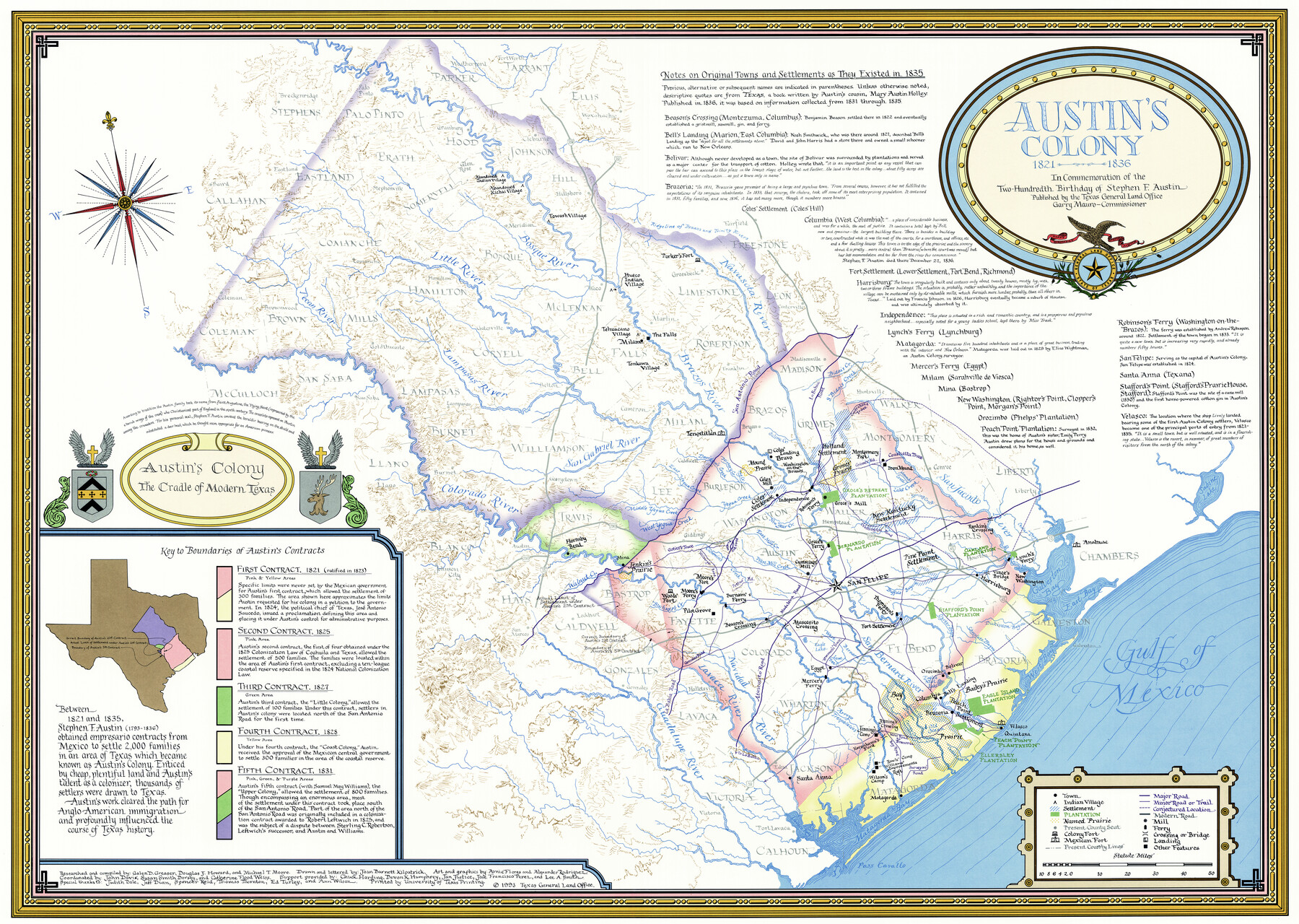
Austin's colony 1821-1836: In commemoration of the two hundredth birthday of Stephen F. Austin
-
Map/Doc
1675
-
Collection
General Map Collection
-
Object Dates
1993 (Creation Date)
-
People and Organizations
Texas General Land Office (Publisher)
University of Texas (Printer)
Galen Greaser (Compiler)
Michael T. Moore (Compiler)
Douglas Howard (Compiler)
Joan Kilpatrick (Draftsman)
-
Subjects
Colony
-
Height x Width
24.6 x 34.5 inches
62.5 x 87.6 cm
-
Medium
paper, etching/engraving/lithograph
-
Comments
Art and graphics by Arnie Flores and Alexander Rodriguez.
Current 1983 county lines, county seats and major roads overlaid on historical data. -
Features
San Felipe
Pine Point Settlement
Thompson's Ferry
Fort Settlement
Rankin's Crossing
Oakland Plantation
Lynch's Ferry
New Washington
Vince's Bridge
Harrisburg
Stafford's Point Plantation
Bolivar
Orozimbo
Columbia
Bell's Landing
Bailey's Prairie
Eagle Island Plantation
Peach Point Settlement
Velasco
Quintana
Bay Prairie
Peach Point Plantation
Ellersley Plantation
Egypt
Mercer's Ferry
Santa Anna
Jenning's Crossing
Jenning's Camp
Karankawa's Ford
Rawls' Camp
Wilson's Camp
Matagorda
Anahuac
Austin's Colony
San Antonio Road
La Bahia Road
Contraband Trace
Grimes' Road
Coushatta Trace
Gotier's Trace
Wilbarger Road
Pettus' Road
Madalena Road
Gonzales Road
Atascosito Road
Washington Road
Newman's Trace
New Road to Brazoria
Bay Road
Surveyor's Road
Navasota River
Bosque River
Little River
Pecan River
Lampasas River
San Gabriel River
Colorado River
Guadalupe River
Lavaca River
Navidad River
San Bernard River
Brazos River
San Jacinto River
Walnut Creek
Buckner's Creek
Wilson's Creek
Arroyo Trespalacios
Cummin's Creek
Caney Creek
Lone Tree Creek
West Bernard Creek
Linville's Bayou
Cedar Lake Creek
Eagle Lake
Eagle's Nest Lake
West Mill Creek
East Mill Creek
New Year Creek
Yegua Creek
Davidson's Creek
Hickory Creek
Hog Creek
Saline Creek
Oyster Bayou
Chocolate Bayou
Dickinson Bayou
Buffalo Bayou
Bidais Creek
Lake Creek
Mound Creek
Spring Creek
Cedar Bayou
Gulf of Mexico
Galveston Bay
East Bay
Matagorda Bay
Lavaca Bay
Pass Cavallo
Sabine Lake
Towash Village
Hueco Indian Village
Tehuacano Village
Tonkawa Village
Milam
Parker's Fort
Tenoxtitlan
Coles' Landing
Bravo
Washington-on-the-Brazos
Coles' Mill
Coles' Settlement
Independence
Mound Prairie
Grimes' Prairie
Holland Settlement
Montgomery Post
New Kentucky Settlement
Groce's Mill
Groce's Retreat Plantation
Robinson's Ferry
Groce's Ferry
Cummings' Mill
Hornsby Bend
Mina
Jenkin's Prairie
Woods' Fort
Moore's Ferry
Moore's Fort
Pilot Grove
Beason's Crossing
Burnam's Ferry
Atascosito Crossing
Part of: General Map Collection

Angelina County Sketch File 5a

Print $4.00
- Digital $50.00
Angelina County Sketch File 5a
1857
Size 8.6 x 7.7 inches
Map/Doc 12931
Flight Mission No. DAG-21K, Frame 43, Matagorda County

Print $20.00
- Digital $50.00
Flight Mission No. DAG-21K, Frame 43, Matagorda County
1952
Size 18.9 x 22.6 inches
Map/Doc 86410
Flight Mission No. CRC-3R, Frame 26, Chambers County

Print $20.00
- Digital $50.00
Flight Mission No. CRC-3R, Frame 26, Chambers County
1956
Size 18.7 x 22.3 inches
Map/Doc 84800
Cottle County Working Sketch 7

Print $20.00
- Digital $50.00
Cottle County Working Sketch 7
1916
Size 28.4 x 30.4 inches
Map/Doc 68317
Leon County Sketch File 2

Print $4.00
- Digital $50.00
Leon County Sketch File 2
1852
Size 8.1 x 5.1 inches
Map/Doc 29711
Potter County

Print $20.00
- Digital $50.00
Potter County
1960
Size 42.5 x 34.6 inches
Map/Doc 73264
Right of Way and Track Map, the Missouri, Kansas and Texas Ry. of Texas - Henrietta Division

Print $20.00
- Digital $50.00
Right of Way and Track Map, the Missouri, Kansas and Texas Ry. of Texas - Henrietta Division
1918
Size 11.8 x 26.9 inches
Map/Doc 64754
Trinity County Working Sketch 22

Print $40.00
- Digital $50.00
Trinity County Working Sketch 22
2009
Size 32.0 x 52.1 inches
Map/Doc 89068
Moore County Sketch File 2

Print $36.00
- Digital $50.00
Moore County Sketch File 2
Size 14.2 x 8.6 inches
Map/Doc 31929
Potter County Sketch File 17

Print $16.00
- Digital $50.00
Potter County Sketch File 17
1920
Size 11.2 x 8.7 inches
Map/Doc 34403
Houston County Working Sketch 12

Print $20.00
- Digital $50.00
Houston County Working Sketch 12
1956
Size 24.0 x 27.3 inches
Map/Doc 66242
You may also like
Aransas County Sketch File 2a

Print $4.00
- Digital $50.00
Aransas County Sketch File 2a
1868
Size 9.3 x 7.7 inches
Map/Doc 13102
San Saba County Sketch File 18

Print $12.00
- Digital $50.00
San Saba County Sketch File 18
1919
Size 11.4 x 8.8 inches
Map/Doc 36460
Flight Mission No. CGN-3P, Frame 142, San Patricio County

Print $20.00
- Digital $50.00
Flight Mission No. CGN-3P, Frame 142, San Patricio County
1956
Size 18.5 x 22.1 inches
Map/Doc 86986
Andrews County Working Sketch 16

Print $20.00
- Digital $50.00
Andrews County Working Sketch 16
1957
Size 36.3 x 44.6 inches
Map/Doc 67062
Map of Yoakum County

Print $40.00
- Digital $50.00
Map of Yoakum County
1900
Size 51.2 x 38.7 inches
Map/Doc 4169
Flight Mission No. DQO-7K, Frame 98, Galveston County

Print $20.00
- Digital $50.00
Flight Mission No. DQO-7K, Frame 98, Galveston County
1952
Size 18.8 x 22.4 inches
Map/Doc 85113
Andrews County Working Sketch 30

Print $40.00
- Digital $50.00
Andrews County Working Sketch 30
1989
Size 34.2 x 48.0 inches
Map/Doc 67076
Winkler County Working Sketch 1

Print $20.00
- Digital $50.00
Winkler County Working Sketch 1
1944
Size 17.5 x 38.9 inches
Map/Doc 72595
Harris County Working Sketch 16

Print $20.00
- Digital $50.00
Harris County Working Sketch 16
1916
Size 19.8 x 21.2 inches
Map/Doc 65908
Midland County Boundary File 4b

Print $18.00
- Digital $50.00
Midland County Boundary File 4b
Size 13.6 x 9.0 inches
Map/Doc 57186
Donley County Sketch File 22

Print $20.00
- Digital $50.00
Donley County Sketch File 22
Size 20.4 x 28.0 inches
Map/Doc 11368
Duval County Rolled Sketch E

Print $20.00
- Digital $50.00
Duval County Rolled Sketch E
1935
Size 36.4 x 37.7 inches
Map/Doc 8808