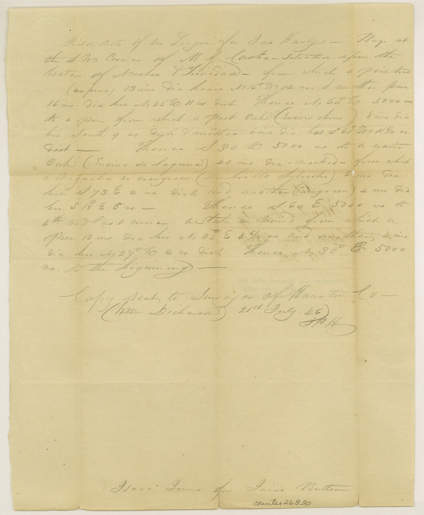
Houston County Sketch File 42
[Field notes of the James Hanly league]
-
Map/Doc
26830
-
Collection
General Map Collection
-
Object Dates
7/21/1846 (Creation Date)
12/10/1984 (File Date)
-
Counties
Houston
-
Subjects
Surveying Sketch File
-
Height x Width
11.5 x 9.5 inches
29.2 x 24.1 cm
-
Medium
paper, manuscript
-
Features
Neches River
Trinity River
Part of: General Map Collection
Flight Mission No. BRE-1P, Frame 73, Nueces County

Print $20.00
- Digital $50.00
Flight Mission No. BRE-1P, Frame 73, Nueces County
1956
Size 18.5 x 22.4 inches
Map/Doc 86655
Crane County Sketch File 2

Print $6.00
- Digital $50.00
Crane County Sketch File 2
1873
Size 17.5 x 11.2 inches
Map/Doc 19557
Flight Mission No. DAG-21K, Frame 125, Matagorda County

Print $20.00
- Digital $50.00
Flight Mission No. DAG-21K, Frame 125, Matagorda County
1952
Size 18.5 x 22.4 inches
Map/Doc 86451
Schleicher County Sketch File 36

Print $20.00
- Digital $50.00
Schleicher County Sketch File 36
1951
Size 15.2 x 21.7 inches
Map/Doc 12309
Pecos County Working Sketch Graphic Index - northwest part - sheet B

Print $20.00
- Digital $50.00
Pecos County Working Sketch Graphic Index - northwest part - sheet B
1975
Size 42.1 x 42.6 inches
Map/Doc 76664
Brazoria County Rolled Sketch 23

Print $20.00
- Digital $50.00
Brazoria County Rolled Sketch 23
1931
Size 39.2 x 37.3 inches
Map/Doc 10691
Ward County Working Sketch 19

Print $20.00
- Digital $50.00
Ward County Working Sketch 19
1949
Size 24.2 x 26.1 inches
Map/Doc 72325
Hudspeth County Working Sketch 28

Print $20.00
- Digital $50.00
Hudspeth County Working Sketch 28
1972
Size 29.2 x 31.3 inches
Map/Doc 66310
Texas Panhandle East Boundary Line

Print $40.00
- Digital $50.00
Texas Panhandle East Boundary Line
1898
Size 9.2 x 64.9 inches
Map/Doc 1716
McMullen County Rolled Sketch WSG

Print $20.00
- Digital $50.00
McMullen County Rolled Sketch WSG
Size 25.8 x 33.9 inches
Map/Doc 6738
Franklin County Sketch File 7

Print $6.00
- Digital $50.00
Franklin County Sketch File 7
1852
Size 8.1 x 10.1 inches
Map/Doc 23020
You may also like
Crockett County Rolled Sketch 80

Print $20.00
- Digital $50.00
Crockett County Rolled Sketch 80
Size 14.0 x 28.5 inches
Map/Doc 5620
Nueces County Sketch File 34

Print $6.00
- Digital $50.00
Nueces County Sketch File 34
1908
Size 11.6 x 12.9 inches
Map/Doc 32611

Phelps's National Map of the United States, a Travellers Guide. Embracing the principal railroads, canals, steamboat & stage routes, throughout the Union

Print $20.00
- Digital $50.00
Phelps's National Map of the United States, a Travellers Guide. Embracing the principal railroads, canals, steamboat & stage routes, throughout the Union
1849
Size 20.9 x 26.3 inches
Map/Doc 95901
[Central Part of County, near Morris County School Land Leagues]
![90486, [Central Part of County, near Morris County School Land Leagues], Twichell Survey Records](https://historictexasmaps.com/wmedia_w700/maps/90486-1.tif.jpg)
Print $20.00
- Digital $50.00
[Central Part of County, near Morris County School Land Leagues]
Size 13.4 x 26.3 inches
Map/Doc 90486
Pecos County Working Sketch 99

Print $20.00
- Digital $50.00
Pecos County Working Sketch 99
1970
Size 43.4 x 31.2 inches
Map/Doc 71572
Atascosa County Sketch File 10

Print $4.00
- Digital $50.00
Atascosa County Sketch File 10
Size 12.1 x 7.7 inches
Map/Doc 13765
Jefferson County Rolled Sketch 53

Print $20.00
- Digital $50.00
Jefferson County Rolled Sketch 53
1969
Size 33.0 x 34.0 inches
Map/Doc 9309
Potter County Working Sketch 12

Print $40.00
- Digital $50.00
Potter County Working Sketch 12
1972
Size 64.4 x 42.4 inches
Map/Doc 71672
Map of a part of Laguna Madre in Willacy & Cameron Counties showing subdivision for mineral development

Print $20.00
- Digital $50.00
Map of a part of Laguna Madre in Willacy & Cameron Counties showing subdivision for mineral development
1950
Size 46.9 x 37.0 inches
Map/Doc 3097
Glasscock County Working Sketch 14

Print $40.00
- Digital $50.00
Glasscock County Working Sketch 14
1984
Size 67.0 x 42.1 inches
Map/Doc 63187
Morris County Rolled Sketch 2A

Print $20.00
- Digital $50.00
Morris County Rolled Sketch 2A
Size 24.0 x 18.6 inches
Map/Doc 10235