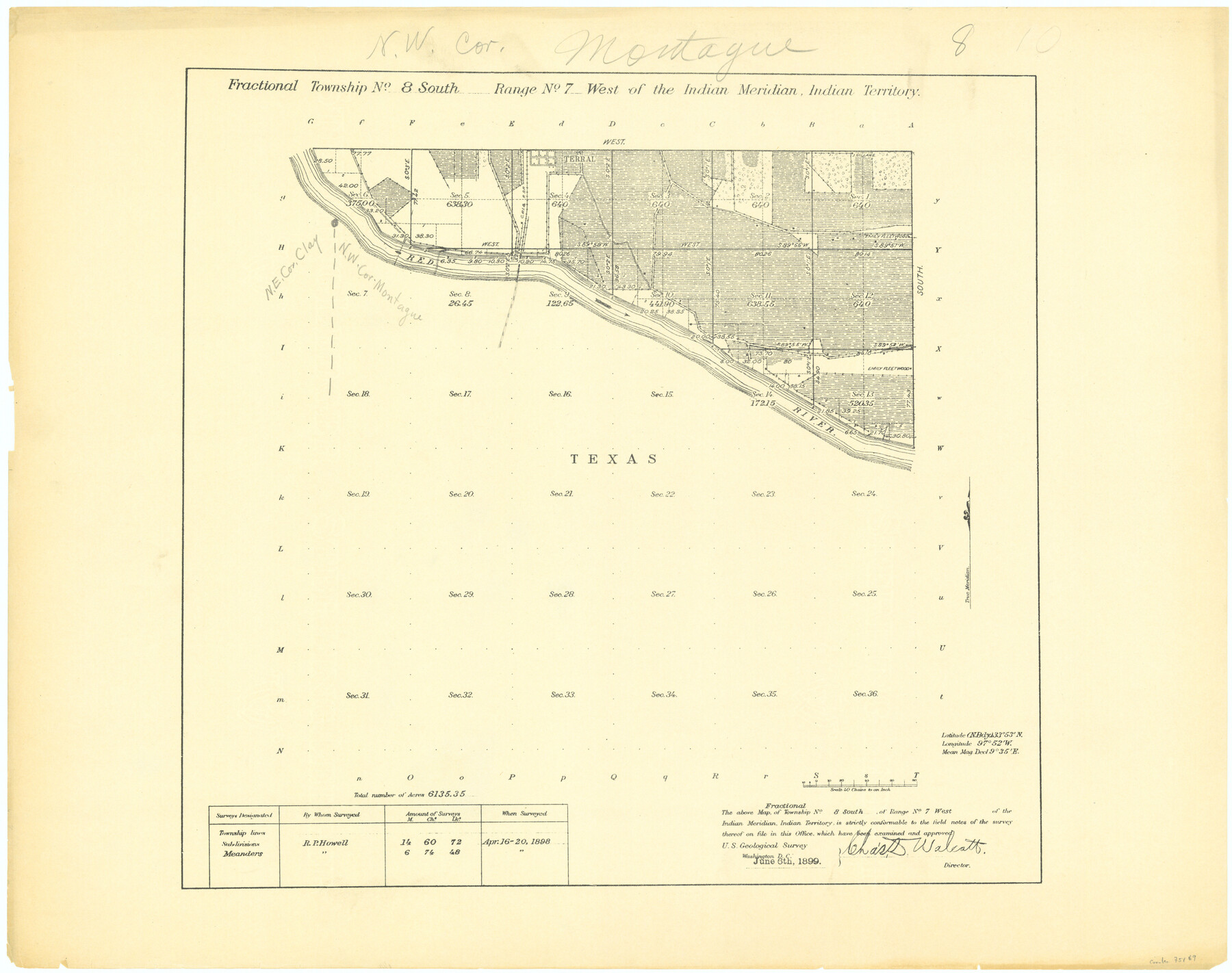
Fractional Township No. 8 South Range No. 7 West of the Indian Meridian, Indian Territory
-
Map/Doc
75169
-
Collection
General Map Collection
-
Object Dates
1898/4/20 (Creation Date)
-
Subjects
Texas Boundaries
-
Height x Width
19.2 x 24.3 inches
48.8 x 61.7 cm
Part of: General Map Collection
PSL Field Notes for Block JKL in Hudspeth County

PSL Field Notes for Block JKL in Hudspeth County
Map/Doc 81658
Mitchell County Sketch File 7A

Print $20.00
- Digital $50.00
Mitchell County Sketch File 7A
1906
Size 20.4 x 14.0 inches
Map/Doc 12097
Travis County Appraisal District Plat Map 2_1004

Print $20.00
- Digital $50.00
Travis County Appraisal District Plat Map 2_1004
Size 21.4 x 26.5 inches
Map/Doc 94238
Jefferson County Rolled Sketch 36

Print $20.00
- Digital $50.00
Jefferson County Rolled Sketch 36
1957
Size 41.1 x 29.1 inches
Map/Doc 6395
Travis County Rolled Sketch 21

Print $20.00
- Digital $50.00
Travis County Rolled Sketch 21
1941
Size 16.2 x 14.7 inches
Map/Doc 8022
No. 1 - Survey for a road from the Brazo Santiago to the Rio Grande

Print $20.00
- Digital $50.00
No. 1 - Survey for a road from the Brazo Santiago to the Rio Grande
1847
Size 18.4 x 27.3 inches
Map/Doc 72875
Glasscock County Sketch File 2

Print $20.00
- Digital $50.00
Glasscock County Sketch File 2
1931
Size 35.1 x 16.2 inches
Map/Doc 11559
Map of Zapata County

Print $40.00
- Digital $50.00
Map of Zapata County
1901
Size 55.1 x 47.7 inches
Map/Doc 16937
Mills County Boundary File 4

Print $40.00
- Digital $50.00
Mills County Boundary File 4
Size 52.1 x 13.3 inches
Map/Doc 57293
Map of survey of a part of Padre and Mustang Islands made for the Office of the Attorney General of the State of Texas

Print $20.00
- Digital $50.00
Map of survey of a part of Padre and Mustang Islands made for the Office of the Attorney General of the State of Texas
1941
Size 40.8 x 39.5 inches
Map/Doc 2257
Hudspeth County Working Sketch 10

Print $20.00
- Digital $50.00
Hudspeth County Working Sketch 10
1941
Size 16.0 x 17.1 inches
Map/Doc 66291
Harris County Sketch File 103

Print $18.00
- Digital $50.00
Harris County Sketch File 103
1992
Size 11.3 x 8.9 inches
Map/Doc 25965
You may also like
Guadalupe County Sketch File 26

Print $4.00
- Digital $50.00
Guadalupe County Sketch File 26
1873
Size 10.2 x 8.2 inches
Map/Doc 24719
The Republic County of Fort Bend. February 4, 1841

Print $20.00
The Republic County of Fort Bend. February 4, 1841
2020
Size 14.7 x 21.6 inches
Map/Doc 96141
Oldham County Boundary File 1d

Print $68.00
- Digital $50.00
Oldham County Boundary File 1d
Size 14.0 x 8.5 inches
Map/Doc 57759
Hays County Working Sketch 1

Print $20.00
- Digital $50.00
Hays County Working Sketch 1
1915
Size 20.0 x 17.3 inches
Map/Doc 66075
Parker County Sketch File 1

Print $4.00
- Digital $50.00
Parker County Sketch File 1
Size 8.5 x 10.4 inches
Map/Doc 33516
Pecos County Sketch File 64

Print $12.00
- Digital $50.00
Pecos County Sketch File 64
1919
Size 11.1 x 8.8 inches
Map/Doc 33818
Harris County Working Sketch 78

Print $20.00
- Digital $50.00
Harris County Working Sketch 78
1968
Size 32.8 x 25.8 inches
Map/Doc 65970
Duval County Rolled Sketch 33A

Print $40.00
- Digital $50.00
Duval County Rolled Sketch 33A
1949
Size 43.8 x 79.5 inches
Map/Doc 8818
Karnes County Working Sketch 10

Print $20.00
- Digital $50.00
Karnes County Working Sketch 10
1970
Size 35.5 x 26.3 inches
Map/Doc 66658
Maps of Gulf Intracoastal Waterway, Texas - Sabine River to the Rio Grande and connecting waterways including ship channels

Print $20.00
- Digital $50.00
Maps of Gulf Intracoastal Waterway, Texas - Sabine River to the Rio Grande and connecting waterways including ship channels
1966
Size 15.6 x 22.0 inches
Map/Doc 61984
Map of Texas With Parts of the Adjoining States

Print $20.00
Map of Texas With Parts of the Adjoining States
1837
Size 29.9 x 25.2 inches
Map/Doc 88998
Taylor County Rolled Sketch 25

Print $20.00
- Digital $50.00
Taylor County Rolled Sketch 25
1962
Size 27.1 x 46.0 inches
Map/Doc 7917