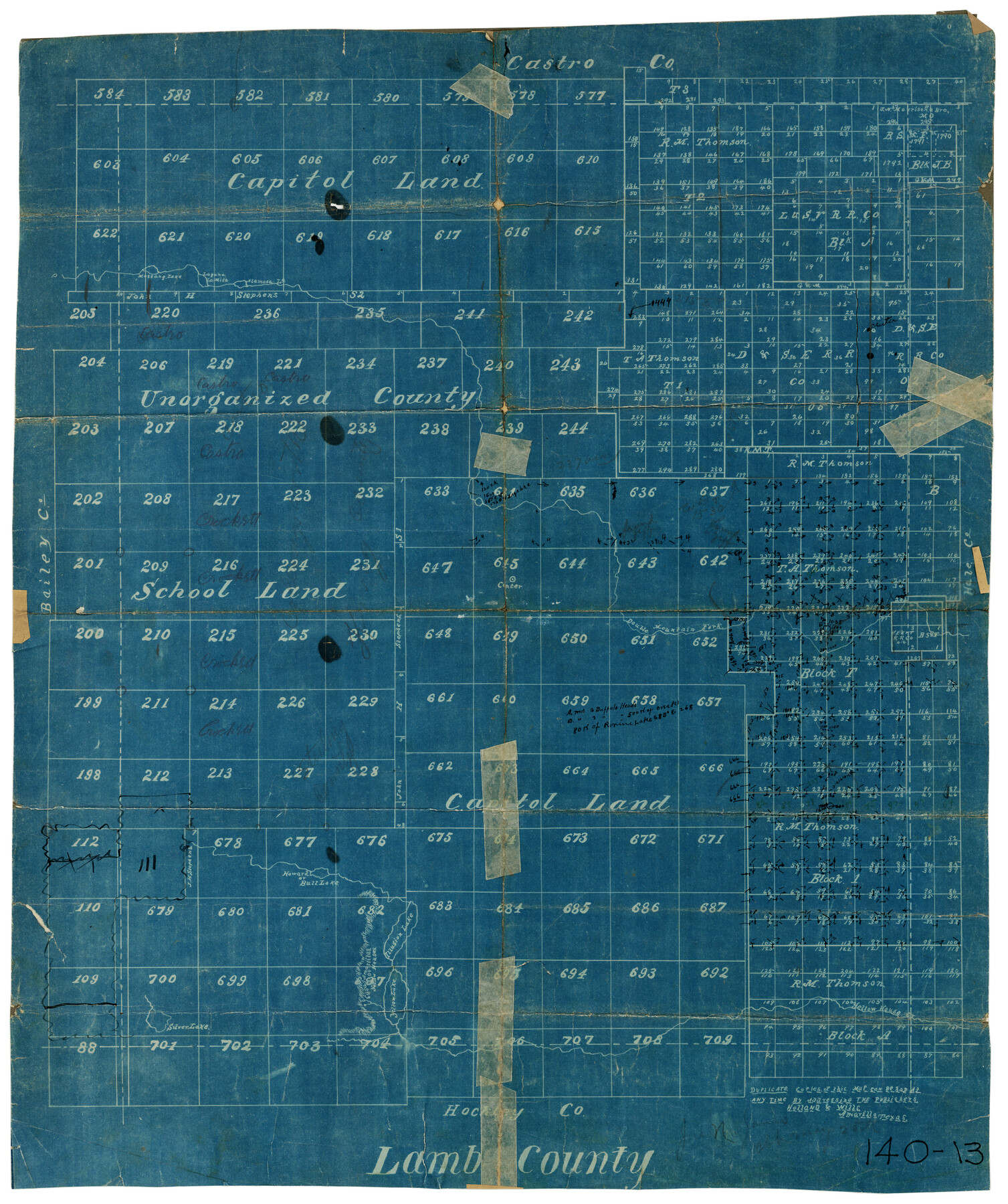
Lamb County
140-13
-
Map/Doc
90985
-
Collection
Twichell Survey Records
-
Counties
Lamb
-
Subjects
County
-
Height x Width
18.2 x 21.4 inches
46.2 x 54.4 cm
Part of: Twichell Survey Records
[Blocks S2, K3, K, and S1]
![90415, [Blocks S2, K3, K, and S1], Twichell Survey Records](https://historictexasmaps.com/wmedia_w700/maps/90415-1.tif.jpg)
Print $20.00
- Digital $50.00
[Blocks S2, K3, K, and S1]
1906
Size 17.9 x 16.4 inches
Map/Doc 90415
Subdivision of Outlots 1 and 2 in Original Townsite of Seagraves, Texas

Print $20.00
- Digital $50.00
Subdivision of Outlots 1 and 2 in Original Townsite of Seagraves, Texas
1955
Size 17.3 x 29.1 inches
Map/Doc 92688
[Sabine County School Land, Block D-10, A3, and B]
![90749, [Sabine County School Land, Block D-10, A3, and B], Twichell Survey Records](https://historictexasmaps.com/wmedia_w700/maps/90749-1.tif.jpg)
Print $20.00
- Digital $50.00
[Sabine County School Land, Block D-10, A3, and B]
Size 15.7 x 20.8 inches
Map/Doc 90749
[PSL Block B-19]
![89811, [PSL Block B-19], Twichell Survey Records](https://historictexasmaps.com/wmedia_w700/maps/89811-1.tif.jpg)
Print $40.00
- Digital $50.00
[PSL Block B-19]
Size 43.7 x 56.6 inches
Map/Doc 89811
Working Sketch in Hutchinson County

Print $20.00
- Digital $50.00
Working Sketch in Hutchinson County
1932
Size 18.4 x 27.0 inches
Map/Doc 91164
Sandhills Water Rights Survey, City of Lubbock, Texas

Print $40.00
- Digital $50.00
Sandhills Water Rights Survey, City of Lubbock, Texas
1957
Size 76.1 x 31.4 inches
Map/Doc 93211
[Sketch of a portion of a Bastrop District GLO map]
![90112, [Sketch of a portion of a Bastrop District GLO map], Twichell Survey Records](https://historictexasmaps.com/wmedia_w700/maps/90112-1.tif.jpg)
Print $20.00
- Digital $50.00
[Sketch of a portion of a Bastrop District GLO map]
1923
Size 12.1 x 16.0 inches
Map/Doc 90112

Littlef[ield], Lamb [County]
![93126, Littlef[ield], Lamb [County], Twichell Survey Records](https://historictexasmaps.com/wmedia_w700/maps/93126-1.tif.jpg)
Print $20.00
- Digital $50.00
Littlef[ield], Lamb [County]
Size 42.9 x 38.5 inches
Map/Doc 93126
Section 21, Block A, Sylvan Sanders Survey

Print $20.00
- Digital $50.00
Section 21, Block A, Sylvan Sanders Survey
1952
Size 24.6 x 16.6 inches
Map/Doc 92723
[Northwest Quarter of County]
![91077, [Northwest Quarter of County], Twichell Survey Records](https://historictexasmaps.com/wmedia_w700/maps/91077-1.tif.jpg)
Print $20.00
- Digital $50.00
[Northwest Quarter of County]
1914
Size 18.6 x 25.7 inches
Map/Doc 91077
[Sketch showing Potter County Block 2] / [Sketch showing F. W. & D. C. Round House]
![91709, [Sketch showing Potter County Block 2] / [Sketch showing F. W. & D. C. Round House], Twichell Survey Records](https://historictexasmaps.com/wmedia_w700/maps/91709-1.tif.jpg)
Print $20.00
- Digital $50.00
[Sketch showing Potter County Block 2] / [Sketch showing F. W. & D. C. Round House]
Size 12.2 x 14.6 inches
Map/Doc 91709
You may also like
Irion County Rolled Sketch 18A

Print $20.00
- Digital $50.00
Irion County Rolled Sketch 18A
Size 45.5 x 29.8 inches
Map/Doc 6327
Fractional Township No. 10 South Range No. 27 East of the Indian Meridian, Indian Territory

Print $20.00
- Digital $50.00
Fractional Township No. 10 South Range No. 27 East of the Indian Meridian, Indian Territory
1897
Size 19.2 x 24.3 inches
Map/Doc 75246
Burleson County Working Sketch 28

Print $20.00
- Digital $50.00
Burleson County Working Sketch 28
1981
Size 17.8 x 17.0 inches
Map/Doc 67747
Right of Way Track Map, Wichita Falls & Southern Railroad Company

Print $40.00
- Digital $50.00
Right of Way Track Map, Wichita Falls & Southern Railroad Company
1942
Size 24.5 x 56.1 inches
Map/Doc 64514
[Sketch showing G. & M. Blocks 5 and M-19 and B. S. & F. Block 9]
![91718, [Sketch showing G. & M. Blocks 5 and M-19 and B. S. & F. Block 9], Twichell Survey Records](https://historictexasmaps.com/wmedia_w700/maps/91718-1.tif.jpg)
Print $20.00
- Digital $50.00
[Sketch showing G. & M. Blocks 5 and M-19 and B. S. & F. Block 9]
Size 22.9 x 17.4 inches
Map/Doc 91718
[H. & T. C. 46, Sections 79- 84]
![91262, [H. & T. C. 46, Sections 79- 84], Twichell Survey Records](https://historictexasmaps.com/wmedia_w700/maps/91262-1.tif.jpg)
Print $20.00
- Digital $50.00
[H. & T. C. 46, Sections 79- 84]
Size 27.3 x 32.6 inches
Map/Doc 91262
Haskell County Rolled Sketch 6

Print $20.00
- Digital $50.00
Haskell County Rolled Sketch 6
1940
Size 22.3 x 19.6 inches
Map/Doc 6166
Hidalgo County Working Sketch 5

Print $20.00
- Digital $50.00
Hidalgo County Working Sketch 5
1956
Size 38.1 x 37.9 inches
Map/Doc 66182
Duval County Working Sketch 47

Print $20.00
- Digital $50.00
Duval County Working Sketch 47
1981
Size 20.8 x 30.9 inches
Map/Doc 68771

Hardeman County Sketch File 8

Print $8.00
- Digital $50.00
Hardeman County Sketch File 8
Size 12.8 x 8.2 inches
Map/Doc 25002
