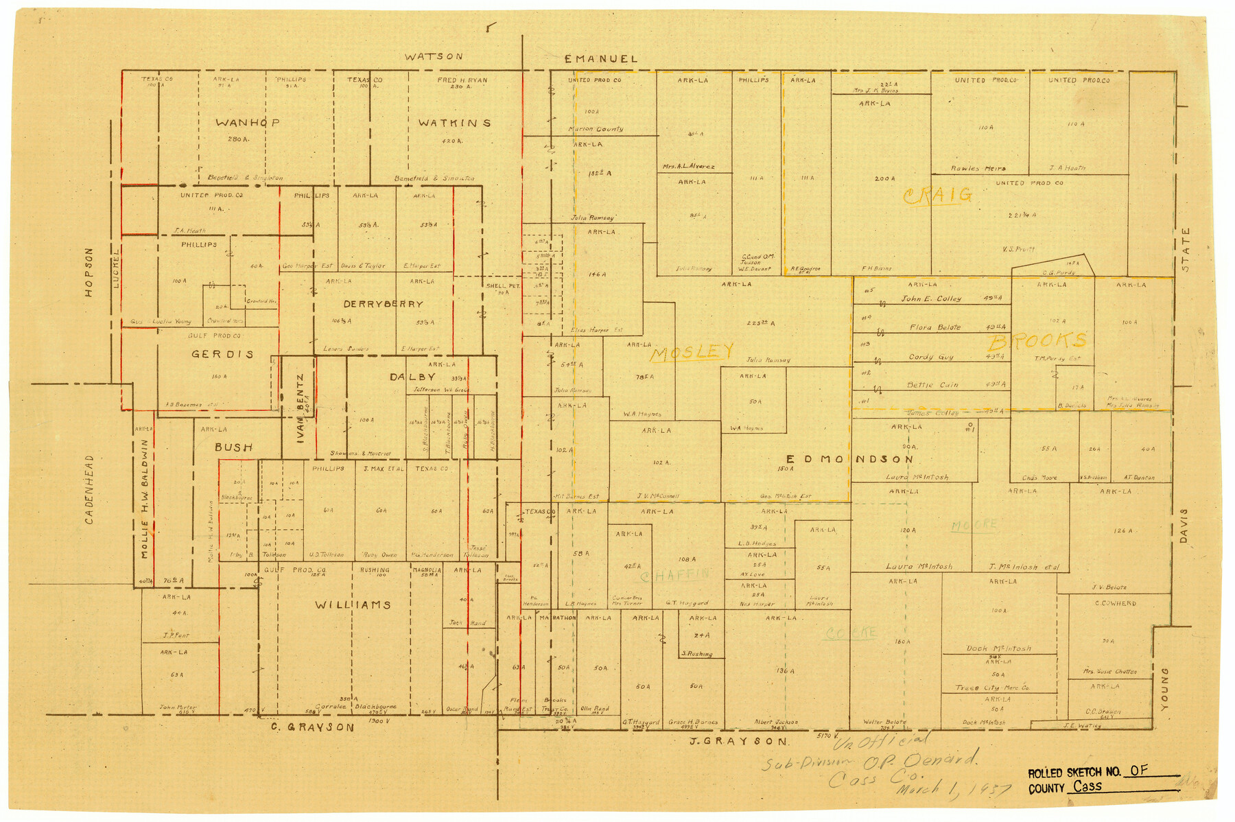
Cass County Rolled Sketch OF
[Unoffcial sub-division, O.P. Denard]
-
Map/Doc
5414
-
Collection
General Map Collection
-
Object Dates
1937/3/1 (Creation Date)
-
Counties
Cass Marion
-
Subjects
Surveying Rolled Sketch
-
Height x Width
16.2 x 24.3 inches
41.1 x 61.7 cm
-
Medium
van dyke/brownline/sepia
Part of: General Map Collection
Gregg County Rolled Sketch JB1

Print $20.00
- Digital $50.00
Gregg County Rolled Sketch JB1
1933
Size 43.3 x 33.4 inches
Map/Doc 9024
H No. 4 - Horn Island Pass, Mississippi Sound

Print $20.00
- Digital $50.00
H No. 4 - Horn Island Pass, Mississippi Sound
1852
Size 14.9 x 19.0 inches
Map/Doc 97225
Reagan County Rolled Sketch 13

Print $20.00
- Digital $50.00
Reagan County Rolled Sketch 13
Size 25.5 x 38.0 inches
Map/Doc 7441
Flight Mission No. CLL-3N, Frame 38, Willacy County

Print $20.00
- Digital $50.00
Flight Mission No. CLL-3N, Frame 38, Willacy County
1954
Size 18.6 x 22.2 inches
Map/Doc 87096
Flight Mission No. DJV-3P, Frame 13, Ellis County

Print $20.00
- Digital $50.00
Flight Mission No. DJV-3P, Frame 13, Ellis County
1956
Size 18.6 x 22.2 inches
Map/Doc 84975
Map of Hemisfair '68 and Downtown San Antonio compliments of the Pearl Brewing Company

Print $3.00
- Digital $50.00
Map of Hemisfair '68 and Downtown San Antonio compliments of the Pearl Brewing Company
1968
Size 6.0 x 11.3 inches
Map/Doc 94793
Frio County Working Sketch 5

Print $20.00
- Digital $50.00
Frio County Working Sketch 5
1936
Size 33.9 x 23.0 inches
Map/Doc 69279
Williamson County Rolled Sketch 11

Print $20.00
- Digital $50.00
Williamson County Rolled Sketch 11
Size 37.5 x 28.4 inches
Map/Doc 8268
Karnes County Boundary File 4

Print $14.00
- Digital $50.00
Karnes County Boundary File 4
Size 12.7 x 8.2 inches
Map/Doc 55698
Llano County Boundary File 1a

Print $44.00
- Digital $50.00
Llano County Boundary File 1a
Size 13.2 x 8.1 inches
Map/Doc 56430
Knox County Rolled Sketch 10

Print $40.00
- Digital $50.00
Knox County Rolled Sketch 10
Size 56.6 x 35.6 inches
Map/Doc 10718

You may also like
Rusk County Sketch File 17

Print $22.00
Rusk County Sketch File 17
1857
Size 12.7 x 15.7 inches
Map/Doc 35520
Hudspeth County Rolled Sketch 45

Print $20.00
- Digital $50.00
Hudspeth County Rolled Sketch 45
1958
Size 20.5 x 35.6 inches
Map/Doc 6254
Anderson County Sketch File 28

Print $34.00
- Digital $50.00
Anderson County Sketch File 28
1927
Size 14.2 x 8.7 inches
Map/Doc 12798
Right of Way and Track Map, the Missouri, Kansas and Texas Ry. of Texas - Henrietta Division

Print $20.00
- Digital $50.00
Right of Way and Track Map, the Missouri, Kansas and Texas Ry. of Texas - Henrietta Division
1918
Size 11.8 x 26.9 inches
Map/Doc 64748
Amistad International Reservoir on Rio Grande 111

Print $20.00
- Digital $50.00
Amistad International Reservoir on Rio Grande 111
1950
Size 28.5 x 41.0 inches
Map/Doc 75542
Flight Mission No. CRC-4R, Frame 154, Chambers County

Print $20.00
- Digital $50.00
Flight Mission No. CRC-4R, Frame 154, Chambers County
1956
Size 18.7 x 22.4 inches
Map/Doc 84917
Map of Caldwell County

Print $20.00
- Digital $50.00
Map of Caldwell County
1871
Size 16.9 x 19.8 inches
Map/Doc 4590
Liberty County Working Sketch 41

Print $20.00
- Digital $50.00
Liberty County Working Sketch 41
1953
Size 21.4 x 20.8 inches
Map/Doc 70500
Erath County Working Sketch 19

Print $20.00
- Digital $50.00
Erath County Working Sketch 19
1963
Size 30.1 x 27.6 inches
Map/Doc 69100
[Additions Surrounding Fort Worth & Denver Railroad Fork]
![92840, [Additions Surrounding Fort Worth & Denver Railroad Fork], Twichell Survey Records](https://historictexasmaps.com/wmedia_w700/maps/92840-1.tif.jpg)
Print $20.00
- Digital $50.00
[Additions Surrounding Fort Worth & Denver Railroad Fork]
Size 32.2 x 32.1 inches
Map/Doc 92840
Upshur County Sketch File 6

Print $4.00
- Digital $50.00
Upshur County Sketch File 6
1855
Size 8.7 x 13.0 inches
Map/Doc 38742
[Sketch of surveys in the vicinity of sections 171 and 172 along Pedernales]
![91880, [Sketch of surveys in the vicinity of sections 171 and 172 along Pedernales], Twichell Survey Records](https://historictexasmaps.com/wmedia_w700/maps/91880-1.tif.jpg)
Print $20.00
- Digital $50.00
[Sketch of surveys in the vicinity of sections 171 and 172 along Pedernales]
Size 15.8 x 14.3 inches
Map/Doc 91880