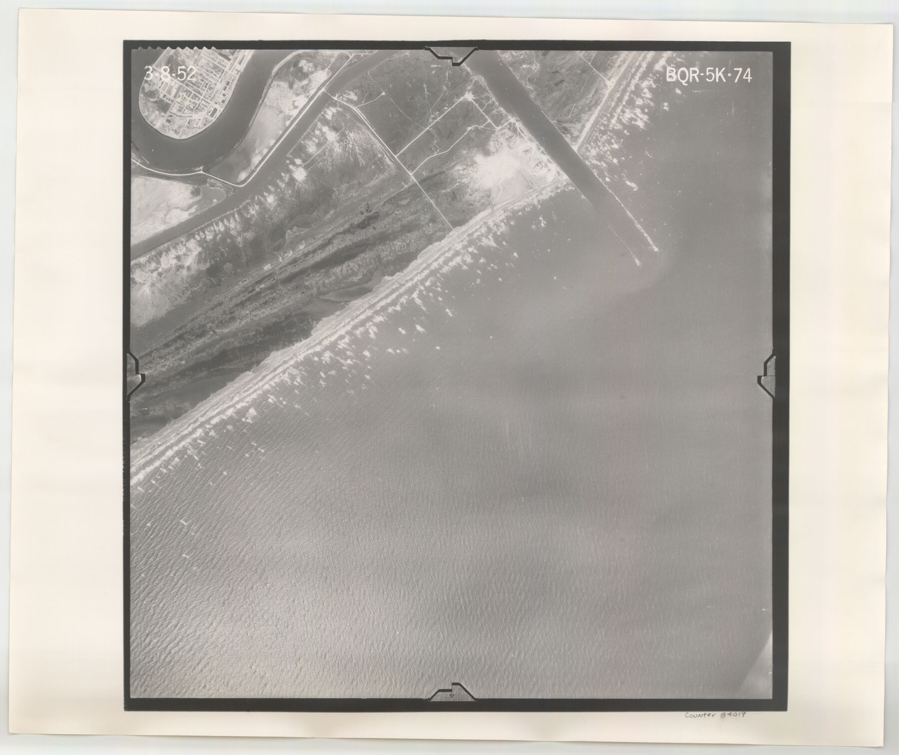
Flight Mission No. BQR-5K, Frame 74, Brazoria County
BQR-5K-74
-
Map/Doc
84019
-
Collection
General Map Collection
-
Object Dates
1952/3/8 (Creation Date)
-
People and Organizations
U. S. Department of Agriculture (Publisher)
-
Counties
Brazoria
-
Subjects
Aerial Photograph
-
Height x Width
18.8 x 22.4 inches
47.8 x 56.9 cm
-
Comments
Flown by Aero Exploration Company of Tulsa, Oklahoma.
Part of: General Map Collection
Young County Rolled Sketch 5

Print $20.00
- Digital $50.00
Young County Rolled Sketch 5
Size 20.2 x 26.1 inches
Map/Doc 8293
Phelps & Ensigns Travellers' Guide, and Map of the United States, containing the roads, distances, steam boat and canal routes & c.

Print $40.00
- Digital $50.00
Phelps & Ensigns Travellers' Guide, and Map of the United States, containing the roads, distances, steam boat and canal routes & c.
1844
Map/Doc 97114
Hockley County Sketch File 4

Print $6.00
- Digital $50.00
Hockley County Sketch File 4
Size 9.1 x 11.2 inches
Map/Doc 26536
Brewster County Rolled Sketch 11

Print $20.00
- Digital $50.00
Brewster County Rolled Sketch 11
1881
Size 24.9 x 23.1 inches
Map/Doc 5191
Dickens County Sketch File G

Print $8.00
- Digital $50.00
Dickens County Sketch File G
Size 12.0 x 8.7 inches
Map/Doc 20854
Flight Mission No. CRC-5R, Frame 33, Chambers County

Print $20.00
- Digital $50.00
Flight Mission No. CRC-5R, Frame 33, Chambers County
1956
Size 18.6 x 22.5 inches
Map/Doc 84952
Travis County Sketch File 52

Print $8.00
- Digital $50.00
Travis County Sketch File 52
1942
Size 14.4 x 8.9 inches
Map/Doc 38391
Flight Mission No. DCL-6C, Frame 5, Kenedy County

Print $20.00
- Digital $50.00
Flight Mission No. DCL-6C, Frame 5, Kenedy County
1943
Size 18.4 x 22.4 inches
Map/Doc 85865

[San Antonio & Aransas Pass]
![64208, [San Antonio & Aransas Pass], General Map Collection](https://historictexasmaps.com/wmedia_w700/maps/64208.tif.jpg)
Print $40.00
- Digital $50.00
[San Antonio & Aransas Pass]
Size 17.0 x 50.7 inches
Map/Doc 64208
Flight Mission No. CGI-3N, Frame 46, Cameron County

Print $20.00
- Digital $50.00
Flight Mission No. CGI-3N, Frame 46, Cameron County
1954
Size 18.7 x 22.2 inches
Map/Doc 84552
Pecos County Boundary File 1a

Print $12.00
- Digital $50.00
Pecos County Boundary File 1a
Size 12.6 x 8.3 inches
Map/Doc 57855
You may also like
Flight Mission No. BRE-1P, Frame 137, Nueces County

Print $20.00
- Digital $50.00
Flight Mission No. BRE-1P, Frame 137, Nueces County
1956
Size 18.7 x 22.6 inches
Map/Doc 86697
Public Land on Mustang Island, Nueces County

Print $20.00
- Digital $50.00
Public Land on Mustang Island, Nueces County
1910
Size 17.0 x 17.5 inches
Map/Doc 93362
Kendall County Boundary File 54

Print $16.00
- Digital $50.00
Kendall County Boundary File 54
Size 8.6 x 3.5 inches
Map/Doc 55769
Sketch in Cochran County, Texas

Print $20.00
- Digital $50.00
Sketch in Cochran County, Texas
1949
Size 21.8 x 21.0 inches
Map/Doc 92495
Kimble County Working Sketch 35

Print $20.00
- Digital $50.00
Kimble County Working Sketch 35
1946
Size 24.7 x 32.0 inches
Map/Doc 70103
Rusk County Sketch File 17a

Print $4.00
Rusk County Sketch File 17a
Size 8.4 x 7.8 inches
Map/Doc 35522
[Blocks M-25 and H]
![92978, [Blocks M-25 and H], Twichell Survey Records](https://historictexasmaps.com/wmedia_w700/maps/92978-1.tif.jpg)
Print $20.00
- Digital $50.00
[Blocks M-25 and H]
1922
Size 17.5 x 13.9 inches
Map/Doc 92978
Hill County Sketch File 2

Print $40.00
- Digital $50.00
Hill County Sketch File 2
1847
Size 15.1 x 12.6 inches
Map/Doc 26461
Flight Mission No. BRE-1P, Frame 67, Nueces County

Print $20.00
- Digital $50.00
Flight Mission No. BRE-1P, Frame 67, Nueces County
1956
Size 18.7 x 22.4 inches
Map/Doc 86649
[Littlefield & White Survey, Kimble County, Texas]
![570, [Littlefield & White Survey, Kimble County, Texas], Maddox Collection](https://historictexasmaps.com/wmedia_w700/maps/0570.tif.jpg)
Print $20.00
- Digital $50.00
[Littlefield & White Survey, Kimble County, Texas]
Size 18.6 x 14.2 inches
Map/Doc 570
Briscoe County Sketch File 9

Print $40.00
- Digital $50.00
Briscoe County Sketch File 9
1896
Size 31.9 x 27.2 inches
Map/Doc 10996
Crockett County Sketch File 81

Print $4.00
- Digital $50.00
Crockett County Sketch File 81
1939
Size 11.3 x 8.5 inches
Map/Doc 19893