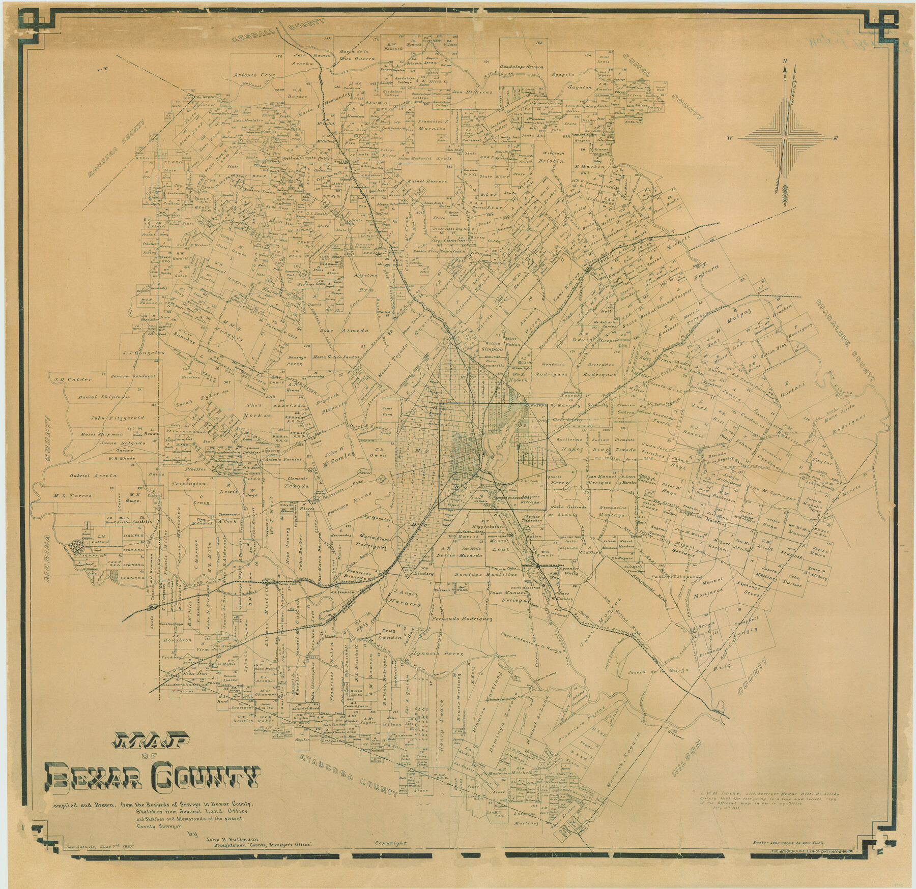
Map of Bexar County
-
Map/Doc
16942
-
Collection
General Map Collection
-
Object Dates
1887/6/7 (Creation Date)
1887/7/20 (File Date)
-
People and Organizations
Bexar County (Publisher)
Strobridge Lith. Co. (Printer)
John D. Rullmann (Compiler)
John D. Rullman (Draftsman)
W.M. Locke (Surveyor/Engineer)
-
Counties
Bexar
-
Subjects
County
-
Height x Width
46.1 x 48.6 inches
117.1 x 123.4 cm
-
Comments
Conservation funded in 2006 by Friends of the Texas General Land Office.
-
Features
Balcones Creek
Vogt Road
Currey Creek Road
Bulverde Road
Rio Cibolo
Bulverde
Rumpel Road
Kraut
Evans Road
Stow Road
Pieper Settlement Road
Blanco City Road
Ujhazi Road
Pecan Spring Road
Helotes Creek
Frederichsburg [sic] Road
Leon Springs
SA&AP
Locke Hill Road
Selma Road
Locke Hill and Selma Road
Prue Road
Coker Road
Tomasini Road
Mud Creek
I&GN
Stahl Road
Judson Road
Selma
Trainer Haile Road
Convers
Seguin Road
Austin Road
Beitel Branch
Nacogdoches Road
Beitel Road
Helotes Road
Olmos Creek
Jones Road
Malzberger Road
Jones and Malzberger Road
Jakson Road
Vihari Road
Hunnam Road
Callaghan Road
Hill and Keller Road
Hill Road
Keller Road
Huebner Road
Bandera Road
Colebra Creek
Brown and Hoffman Road
Brown Road
Hoffman Road
Upper Castroville Road
Leon Creek
Culebra Road
Alamo Ditch
Main San Pedro Ditch
San Antonio River
Currey Creek
Dashiel Road
Gibbs Road
Binz Engelman Road
Stanus Road
Wheatley Road
Martinez Creek
Salatrillo Creek
Lower Seguin Road
Miller Road
Gembler Road
Brakary Road
Demmer Road
St. Hedwig
Lipan Road
St. Hedwig Road
Mt. Oliver Road
Brannon Creek
Beck Road
W. W. White Road
Old Sulphur Spring Road
San Pedro Creek
Drown
Saus Creek
Castroville
Luckie Road
Cagnion Road
Medio Creek
Pyron Road
Mission de la Concepcion
Mission de San Jose
San Jose Road
San Geronimo Creek
Upson Road
Salado Creek
Rosilla Creek
New Sulphur Spring Road
Flourney and Foster Road
Flourney Road
Foster Road
New Gonzales Road
Babcock Road
McLean Road
Lennox Road
Pirie Road
Pittman Road
Felix Road
Chapaderas Creek
Grayton Road
Lodi Road
Hildebrandt Road
Convers Road
Convers and Grayton Road
Jose Flores Road
San Juan Road
Mission de San Juan
Aschley Road
Chavano Road
Espada Road
Mission de la Espada
Arroyo de la Piedro
Arroyo de la Minita
Laredo Road
Somerset Road
Frio City Road
GH&SA
Mans Crossing
Moos
Quintana Road
Medina Siding
Nelson Road
Bertel Creek
Castroville Road
Rockport Road
Elm Creek
Lacoste Station
Wisdom Road
Benton City Road
Cottonwood Creek
Medina River
Garzas Crossing
Palo Alto Road
Perez Crossing
Applewhite Road
Martinez Road
Carmel Church
Corpus Christi Road
Losoyo Crossing
Upper Labor Ditch
Laguna Redondo Road
Chavez Road
Old Goliad Road
Elmendorf
Elmendorf Road
Calaveras Creek
Lower Miller Road
Parita Creek
Eagle Creek
Calaveras
Paso de la Boregos Road
Lacombe Road
Rockport and Castroville Road
Kerr's Crossing
Bridge [on Lacombe Road]
Payne Road
East Somerset Road
Jose Flores Road
McCluskey Road
Green Road
Kinney Road
Greyton
-
URLs
https://medium.com/save-texas-history/mapping-texas-from-frontier-to-the-lone-star-state-bexar-county-8476738518
Part of: General Map Collection
Flight Mission No. BRA-7M, Frame 145, Jefferson County

Print $20.00
- Digital $50.00
Flight Mission No. BRA-7M, Frame 145, Jefferson County
1953
Size 16.0 x 16.0 inches
Map/Doc 85539
Flight Mission No. DQO-7K, Frame 84, Galveston County

Print $20.00
- Digital $50.00
Flight Mission No. DQO-7K, Frame 84, Galveston County
1952
Size 18.8 x 22.5 inches
Map/Doc 85111
Howard County

Print $20.00
- Digital $50.00
Howard County
1922
Size 41.3 x 35.2 inches
Map/Doc 73185
Orange County NRC Article 33.136 Sketch 5

Print $62.00
- Digital $50.00
Orange County NRC Article 33.136 Sketch 5
2014
Size 26.1 x 22.7 inches
Map/Doc 94946
Jeff Davis County Rolled Sketch 13A

Print $20.00
- Digital $50.00
Jeff Davis County Rolled Sketch 13A
1921
Size 19.0 x 23.1 inches
Map/Doc 6367
Orange County Working Sketch 17

Print $20.00
- Digital $50.00
Orange County Working Sketch 17
1930
Size 35.6 x 26.1 inches
Map/Doc 71349
Caldwell County Sketch File 6

Print $8.00
- Digital $50.00
Caldwell County Sketch File 6
1922
Size 14.1 x 8.1 inches
Map/Doc 35847
McMullen County

Print $40.00
- Digital $50.00
McMullen County
1967
Size 49.7 x 34.8 inches
Map/Doc 73236
Briscoe County Sketch File 12

Print $4.00
- Digital $50.00
Briscoe County Sketch File 12
1927
Size 11.2 x 8.8 inches
Map/Doc 16426
Flight Mission No. DAG-21K, Frame 117, Matagorda County

Print $20.00
- Digital $50.00
Flight Mission No. DAG-21K, Frame 117, Matagorda County
1952
Size 18.5 x 22.4 inches
Map/Doc 86440
Blanco County Sketch File 25

Print $40.00
- Digital $50.00
Blanco County Sketch File 25
1888
Size 17.1 x 14.2 inches
Map/Doc 14616
Brazoria County Rolled Sketch 18B

Print $20.00
- Digital $50.00
Brazoria County Rolled Sketch 18B
1914
Size 10.0 x 17.3 inches
Map/Doc 5165
You may also like
Right of Way & Track Map Houston & Brazos Valley Ry. operated by Houston & Brazos Valley Ry. Co., Hoskins Mound Branch

Print $40.00
- Digital $50.00
Right of Way & Track Map Houston & Brazos Valley Ry. operated by Houston & Brazos Valley Ry. Co., Hoskins Mound Branch
1924
Size 25.3 x 56.4 inches
Map/Doc 64611
Stephens County Working Sketch 10

Print $40.00
- Digital $50.00
Stephens County Working Sketch 10
1921
Size 36.1 x 64.1 inches
Map/Doc 63953
Travis County Boundary File 4a

Print $40.00
- Digital $50.00
Travis County Boundary File 4a
Size 27.9 x 17.8 inches
Map/Doc 59428
Flight Mission No. CRC-1R, Frame 39, Chambers County

Print $20.00
- Digital $50.00
Flight Mission No. CRC-1R, Frame 39, Chambers County
1956
Size 18.8 x 22.4 inches
Map/Doc 84707
Preliminary Sketch of Galveston Bay, Texas

Print $20.00
Preliminary Sketch of Galveston Bay, Texas
1852
Size 22.6 x 18.3 inches
Map/Doc 79317
Titus County Working Sketch 7

Print $20.00
- Digital $50.00
Titus County Working Sketch 7
1970
Size 31.5 x 28.7 inches
Map/Doc 69368

Travis County Rolled Sketch 25

Print $20.00
- Digital $50.00
Travis County Rolled Sketch 25
1942
Size 22.1 x 29.2 inches
Map/Doc 8026
Goliad County Sketch File 1

Print $24.00
- Digital $50.00
Goliad County Sketch File 1
1857
Size 12.5 x 7.5 inches
Map/Doc 24211
Right of Way & Track Map San Antonio & Aransas Pass Railway Co.

Print $40.00
- Digital $50.00
Right of Way & Track Map San Antonio & Aransas Pass Railway Co.
1919
Size 25.8 x 57.1 inches
Map/Doc 64027
Presidio County Sketch File 105

Print $20.00
- Digital $50.00
Presidio County Sketch File 105
Size 15.6 x 42.6 inches
Map/Doc 11726
Harris County Sketch File A

Print $4.00
- Digital $50.00
Harris County Sketch File A
1898
Size 12.8 x 8.5 inches
Map/Doc 25306