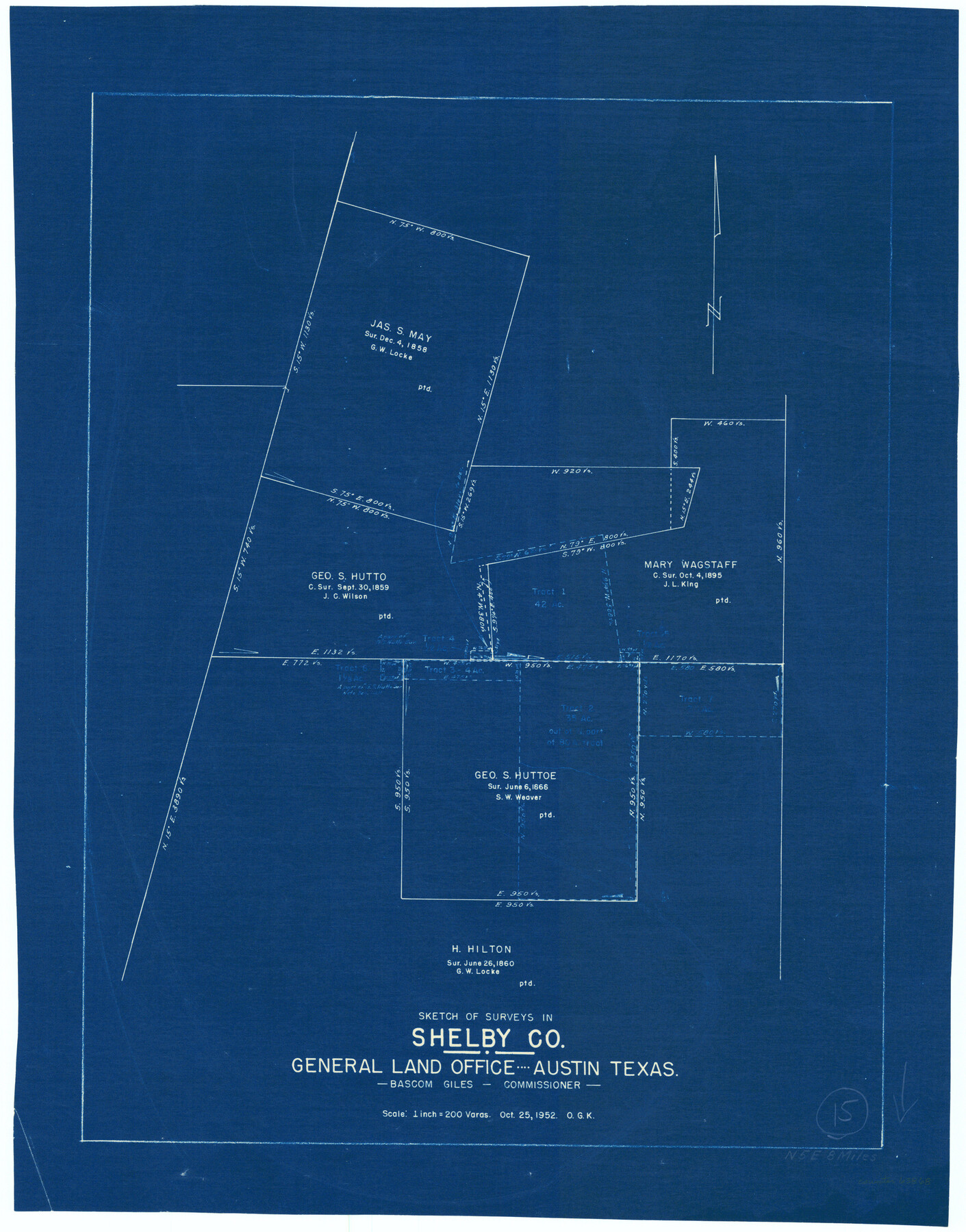
Shelby County Working Sketch 15
-
Map/Doc
63868
-
Collection
General Map Collection
-
Object Dates
10/25/1952 (Creation Date)
-
People and Organizations
Otto G. Kurio (Draftsman)
-
Counties
Shelby
-
Subjects
Surveying Working Sketch
-
Height x Width
24.5 x 19.2 inches
62.2 x 48.8 cm
-
Scale
1" = 200 varas
Part of: General Map Collection
Dimmit County Boundary File 2

Print $4.00
- Digital $50.00
Dimmit County Boundary File 2
Size 10.0 x 7.9 inches
Map/Doc 52564
Irion County Working Sketch 11

Print $20.00
- Digital $50.00
Irion County Working Sketch 11
1959
Size 43.6 x 30.6 inches
Map/Doc 66420
Newton County Sketch File 5

Print $8.00
- Digital $50.00
Newton County Sketch File 5
Size 8.2 x 12.8 inches
Map/Doc 32368
Map of Newton Co.

Print $20.00
- Digital $50.00
Map of Newton Co.
1905
Size 47.5 x 38.9 inches
Map/Doc 5020
Hudspeth County Rolled Sketch 57

Print $20.00
- Digital $50.00
Hudspeth County Rolled Sketch 57
Size 38.3 x 46.0 inches
Map/Doc 9223
Dimmit County Sketch File 34

Print $4.00
- Digital $50.00
Dimmit County Sketch File 34
1884
Size 9.0 x 8.7 inches
Map/Doc 21153
Flight Mission No. BRA-16M, Frame 90, Jefferson County

Print $20.00
- Digital $50.00
Flight Mission No. BRA-16M, Frame 90, Jefferson County
1953
Size 18.5 x 22.2 inches
Map/Doc 85702
Knox County Sketch File 21

Print $16.00
- Digital $50.00
Knox County Sketch File 21
1917
Size 3.7 x 8.6 inches
Map/Doc 29243
Glasscock County

Print $20.00
- Digital $50.00
Glasscock County
1899
Size 38.1 x 33.9 inches
Map/Doc 4707
Controlled Mosaic by Jack Amman Photogrammetric Engineers, Inc - Sheet 25

Print $20.00
- Digital $50.00
Controlled Mosaic by Jack Amman Photogrammetric Engineers, Inc - Sheet 25
1954
Size 20.0 x 24.0 inches
Map/Doc 83476
Panola County

Print $20.00
- Digital $50.00
Panola County
1947
Size 40.8 x 40.3 inches
Map/Doc 66969
[Copy of a portion of] The Coast & Bays of Western Texas, St. Joseph's and Mustang Islands from Actual Survey, the Remainder from County Maps, Etc.
![72770, [Copy of a portion of] The Coast & Bays of Western Texas, St. Joseph's and Mustang Islands from Actual Survey, the Remainder from County Maps, Etc., General Map Collection](https://historictexasmaps.com/wmedia_w700/maps/72770.tif.jpg)
Print $20.00
- Digital $50.00
[Copy of a portion of] The Coast & Bays of Western Texas, St. Joseph's and Mustang Islands from Actual Survey, the Remainder from County Maps, Etc.
1857
Size 25.7 x 18.3 inches
Map/Doc 72770
You may also like
Aransas County Rolled Sketch 26

Print $20.00
- Digital $50.00
Aransas County Rolled Sketch 26
1984
Size 18.3 x 24.4 inches
Map/Doc 5060
Freestone County Working Sketch 31a

Print $20.00
- Digital $50.00
Freestone County Working Sketch 31a
1996
Size 25.4 x 31.9 inches
Map/Doc 69273
Presidio County Working Sketch 93

Print $20.00
- Digital $50.00
Presidio County Working Sketch 93
1976
Size 27.7 x 27.3 inches
Map/Doc 71770
Dickens County

Print $20.00
- Digital $50.00
Dickens County
1891
Size 27.7 x 21.9 inches
Map/Doc 66804
[Sketch for Mineral Application 21493 - Clay County]
![65626, [Sketch for Mineral Application 21493 - Clay County], General Map Collection](https://historictexasmaps.com/wmedia_w700/maps/65626-1.tif.jpg)
Print $40.00
- Digital $50.00
[Sketch for Mineral Application 21493 - Clay County]
Size 63.1 x 35.3 inches
Map/Doc 65626
Flight Mission No. DQO-12K, Frame 35, Galveston County

Print $20.00
- Digital $50.00
Flight Mission No. DQO-12K, Frame 35, Galveston County
1952
Size 18.7 x 22.4 inches
Map/Doc 85226
[Aransas and Corpus Christi Bays]
![140, [Aransas and Corpus Christi Bays], General Map Collection](https://historictexasmaps.com/wmedia_w700/maps/140.tif.jpg)
Print $3.00
- Digital $50.00
[Aransas and Corpus Christi Bays]
1839
Size 11.4 x 16.5 inches
Map/Doc 140
Nacogdoches County Rolled Sketch 2

Print $20.00
- Digital $50.00
Nacogdoches County Rolled Sketch 2
1949
Size 44.3 x 42.3 inches
Map/Doc 46837
[Sections 58-63, I. & G. N. Block 1 and adjacent area]
![91614, [Sections 58-63, I. & G. N. Block 1 and adjacent area], Twichell Survey Records](https://historictexasmaps.com/wmedia_w700/maps/91614-1.tif.jpg)
Print $20.00
- Digital $50.00
[Sections 58-63, I. & G. N. Block 1 and adjacent area]
Size 21.3 x 14.4 inches
Map/Doc 91614
Kenedy County Boundary File 1

Print $10.00
- Digital $50.00
Kenedy County Boundary File 1
Size 9.1 x 5.5 inches
Map/Doc 55777
Gaines County Sketch

Print $20.00
- Digital $50.00
Gaines County Sketch
Size 9.7 x 18.5 inches
Map/Doc 92668
Terry County Sketch File 20

Print $4.00
- Digital $50.00
Terry County Sketch File 20
2001
Size 11.1 x 8.8 inches
Map/Doc 76365