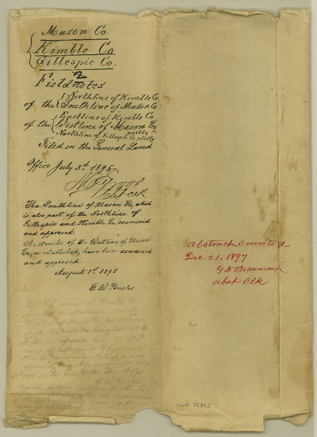
Mason County Boundary File 5
Field notes of the North line of Kimble Co., South line of Mason Co., East line of Kimble Co., West line of Mason Co., North line of Gillespie Co. partly
-
Map/Doc
56862
-
Collection
General Map Collection
-
Counties
Mason
-
Subjects
County Boundaries
-
Height x Width
9.7 x 7.0 inches
24.6 x 17.8 cm
Part of: General Map Collection
Dallas County Sketch File 18a

Print $20.00
- Digital $50.00
Dallas County Sketch File 18a
Size 12.4 x 23.8 inches
Map/Doc 11286
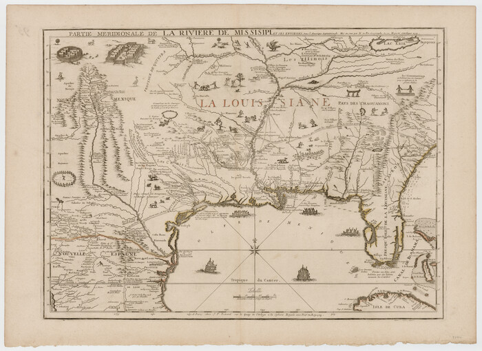
Partie Meridionale de la Riviere de Missisipi, et ses environs dans l'Amerique Septentrionale
Print $20.00
- Digital $50.00
Partie Meridionale de la Riviere de Missisipi, et ses environs dans l'Amerique Septentrionale
1718
Size 22.0 x 30.3 inches
Map/Doc 93926
Flight Mission No. DCL-5C, Frame 77, Kenedy County

Print $20.00
- Digital $50.00
Flight Mission No. DCL-5C, Frame 77, Kenedy County
1943
Size 18.5 x 22.4 inches
Map/Doc 85860
Maps of Gulf Intracoastal Waterway, Texas - Sabine River to the Rio Grande and connecting waterways including ship channels

Print $20.00
- Digital $50.00
Maps of Gulf Intracoastal Waterway, Texas - Sabine River to the Rio Grande and connecting waterways including ship channels
1966
Size 14.5 x 22.2 inches
Map/Doc 61919
Oldham County Rolled Sketch T

Print $20.00
- Digital $50.00
Oldham County Rolled Sketch T
1903
Size 42.3 x 46.2 inches
Map/Doc 9642
Hudspeth County Rolled Sketch 73

Print $40.00
- Digital $50.00
Hudspeth County Rolled Sketch 73
1992
Size 38.9 x 49.3 inches
Map/Doc 9236
Mitchell County Sketch File 18

Print $20.00
- Digital $50.00
Mitchell County Sketch File 18
Size 32.1 x 13.6 inches
Map/Doc 12103
Dimmit County Working Sketch 15

Print $20.00
- Digital $50.00
Dimmit County Working Sketch 15
1942
Size 19.0 x 34.5 inches
Map/Doc 68676
Flight Mission No. CRC-2R, Frame 184, Chambers County

Print $20.00
- Digital $50.00
Flight Mission No. CRC-2R, Frame 184, Chambers County
1956
Size 18.6 x 22.2 inches
Map/Doc 84762
Flight Mission No. BQR-20K, Frame 15, Brazoria County

Print $20.00
- Digital $50.00
Flight Mission No. BQR-20K, Frame 15, Brazoria County
1952
Size 18.6 x 22.3 inches
Map/Doc 84117
Presidio County Working Sketch 121b

Print $20.00
- Digital $50.00
Presidio County Working Sketch 121b
1984
Size 36.0 x 41.5 inches
Map/Doc 71799
Travis County Rolled Sketch 3

Print $40.00
- Digital $50.00
Travis County Rolled Sketch 3
1902
Size 37.2 x 48.0 inches
Map/Doc 10009
You may also like
Carson County Boundary File 6

Print $48.00
- Digital $50.00
Carson County Boundary File 6
Size 12.8 x 8.3 inches
Map/Doc 51151
[Sketch for Mineral Application 24072, San Jacinto River]
![65604, [Sketch for Mineral Application 24072, San Jacinto River], General Map Collection](https://historictexasmaps.com/wmedia_w700/maps/65604.tif.jpg)
Print $20.00
- Digital $50.00
[Sketch for Mineral Application 24072, San Jacinto River]
1929
Size 23.3 x 17.5 inches
Map/Doc 65604
Trinity County Sketch File 41

Print $4.00
- Digital $50.00
Trinity County Sketch File 41
1857
Size 10.0 x 8.0 inches
Map/Doc 38597
Flight Mission No. CLL-1N, Frame 185, Willacy County

Print $20.00
- Digital $50.00
Flight Mission No. CLL-1N, Frame 185, Willacy County
1954
Size 18.4 x 22.1 inches
Map/Doc 87055
Pecos County Rolled Sketch DK3

Print $20.00
- Digital $50.00
Pecos County Rolled Sketch DK3
1938
Size 35.3 x 42.3 inches
Map/Doc 9715
Flight Mission No. CGI-3N, Frame 120, Cameron County

Print $20.00
- Digital $50.00
Flight Mission No. CGI-3N, Frame 120, Cameron County
1954
Size 18.8 x 22.3 inches
Map/Doc 84593
Map of Giddings

Print $20.00
- Digital $50.00
Map of Giddings
1940
Size 16.5 x 21.2 inches
Map/Doc 2210
Tourists' Handbook Descriptive of Colorado, New Mexico and Utah

Tourists' Handbook Descriptive of Colorado, New Mexico and Utah
1898
Size 9.4 x 6.4 inches
Map/Doc 97075
Atascosa County Sketch File 36

Print $20.00
- Digital $50.00
Atascosa County Sketch File 36
1947
Size 16.0 x 22.3 inches
Map/Doc 10867
New and Correct Map of the Great Rock Island Route - Chicago, Rock Island, & Pacific Railway

Print $20.00
- Digital $50.00
New and Correct Map of the Great Rock Island Route - Chicago, Rock Island, & Pacific Railway
1892
Size 20.0 x 42.2 inches
Map/Doc 95865
Loving County

Print $20.00
- Digital $50.00
Loving County
1889
Size 24.7 x 20.1 inches
Map/Doc 91319
Edwards County Working Sketch 44

Print $20.00
- Digital $50.00
Edwards County Working Sketch 44
1950
Size 44.1 x 26.0 inches
Map/Doc 68920