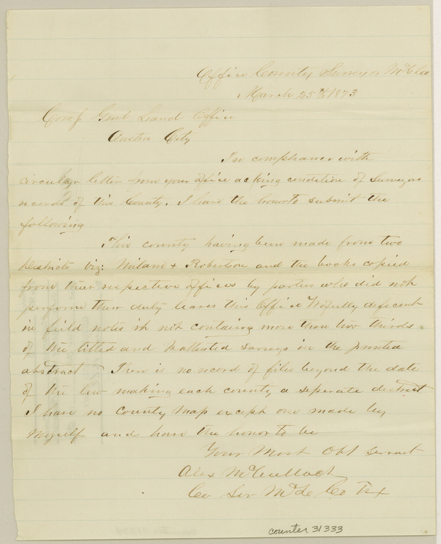
McLennan County Sketch File 43
[Surveyor's report on county records]
-
Map/Doc
31333
-
Collection
General Map Collection
-
Object Dates
3/25/1873 (Creation Date)
11/30/1984 (File Date)
-
People and Organizations
Alex McCulloch ()
-
Counties
McLennan
-
Subjects
Surveying Sketch File
-
Height x Width
10.0 x 8.1 inches
25.4 x 20.6 cm
-
Medium
paper, manuscript
Part of: General Map Collection
Edwards County Working Sketch 95

Print $20.00
- Digital $50.00
Edwards County Working Sketch 95
1968
Size 26.0 x 24.9 inches
Map/Doc 68971
Upshur County Sketch File 22

Print $8.00
- Digital $50.00
Upshur County Sketch File 22
2015
Size 11.0 x 8.5 inches
Map/Doc 93774
[Surveys in the Robertson District along the Trinity River and Richland Creek]
![104, [Surveys in the Robertson District along the Trinity River and Richland Creek], General Map Collection](https://historictexasmaps.com/wmedia_w700/maps/104.tif.jpg)
Print $20.00
- Digital $50.00
[Surveys in the Robertson District along the Trinity River and Richland Creek]
1841
Size 15.3 x 12.2 inches
Map/Doc 104
Red River County

Print $20.00
- Digital $50.00
Red River County
1934
Size 46.0 x 39.2 inches
Map/Doc 73272
Coke County Rolled Sketch 18

Print $20.00
- Digital $50.00
Coke County Rolled Sketch 18
Size 43.4 x 34.4 inches
Map/Doc 8632
Pecos County Rolled Sketch 83

Print $20.00
- Digital $50.00
Pecos County Rolled Sketch 83
1931
Size 17.6 x 26.2 inches
Map/Doc 7242
PSL Field Notes for Blocks 1, 5, 6, and 7 in El Paso County and Blocks 2, 3, 4, 8, 9, 10, 11, 12, 13, and 14 in Hudspeth County

PSL Field Notes for Blocks 1, 5, 6, and 7 in El Paso County and Blocks 2, 3, 4, 8, 9, 10, 11, 12, 13, and 14 in Hudspeth County
Map/Doc 81653
McMullen County Sketch File 5

Print $4.00
- Digital $50.00
McMullen County Sketch File 5
1854
Size 8.7 x 8.3 inches
Map/Doc 31343
In the Supreme Court of the United States The State of Oklahoma, Complainant vs. The State of Texas, Defendant, The United States of America, Intervener - 1920

Print $20.00
- Digital $50.00
In the Supreme Court of the United States The State of Oklahoma, Complainant vs. The State of Texas, Defendant, The United States of America, Intervener - 1920
1920
Size 32.4 x 36.8 inches
Map/Doc 75129
Lampasas County Working Sketch 10

Print $20.00
- Digital $50.00
Lampasas County Working Sketch 10
1963
Size 32.2 x 42.9 inches
Map/Doc 70287
Map of Parker County

Print $20.00
- Digital $50.00
Map of Parker County
1871
Size 20.9 x 18.4 inches
Map/Doc 3942
Grayson County Working Sketch 21

Print $20.00
- Digital $50.00
Grayson County Working Sketch 21
1961
Size 42.6 x 26.5 inches
Map/Doc 63260
You may also like
New Map of Texas with the Contiguous American and Mexican States

Print $20.00
New Map of Texas with the Contiguous American and Mexican States
1835
Size 13.3 x 15.9 inches
Map/Doc 88894
Caldwell County Working Sketch 8

Print $20.00
- Digital $50.00
Caldwell County Working Sketch 8
1964
Size 29.1 x 22.8 inches
Map/Doc 67838
Flight Mission No. BRA-8M, Frame 69, Jefferson County

Print $20.00
- Digital $50.00
Flight Mission No. BRA-8M, Frame 69, Jefferson County
1953
Size 18.6 x 22.1 inches
Map/Doc 85589
Coke County Sketch File 1

Print $8.00
- Digital $50.00
Coke County Sketch File 1
1858
Size 8.3 x 7.7 inches
Map/Doc 18562
Terrell County Working Sketch 84c

Print $20.00
- Digital $50.00
Terrell County Working Sketch 84c
1992
Size 18.2 x 31.3 inches
Map/Doc 69607
Nueces County Rolled Sketch 113B

Print $20.00
- Digital $50.00
Nueces County Rolled Sketch 113B
1972
Size 18.6 x 24.2 inches
Map/Doc 7123
Harrison County Working Sketch 14

Print $20.00
- Digital $50.00
Harrison County Working Sketch 14
1961
Size 35.6 x 32.0 inches
Map/Doc 66034

Working Sketch Hale County

Print $20.00
- Digital $50.00
Working Sketch Hale County
1909
Size 17.9 x 20.9 inches
Map/Doc 90745
Map of Grayson County

Print $20.00
- Digital $50.00
Map of Grayson County
1859
Size 22.6 x 19.5 inches
Map/Doc 3600
Austin County Sketch File 17

Print $4.00
- Digital $50.00
Austin County Sketch File 17
1873
Size 5.9 x 8.3 inches
Map/Doc 13925
Map of Duval County

Print $40.00
- Digital $50.00
Map of Duval County
1890
Size 69.8 x 43.8 inches
Map/Doc 4936