Treaty to Resolve Pending Boundary Differences and Maintain the Rio Grande and Colorado River as the International Boundary Between the United States of American and Mexico
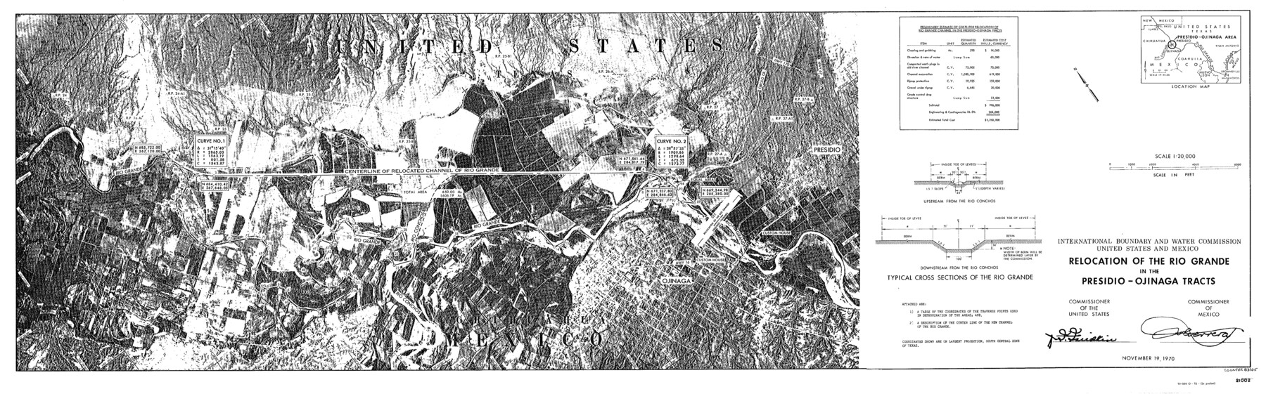
International Boundary and Water Commission United States and Mexico Relocation of the Rio Grande in the Presidio - Ojinaga Tracts
-
Map/Doc
83105
-
Collection
General Map Collection
-
Object Dates
1970/12/12 (Creation Date)
-
People and Organizations
United States Department of State (Publisher)
U. S. Government Printing Office (Printer)
-
Subjects
Texas Boundaries
-
Height x Width
11.0 x 35.2 inches
27.9 x 89.4 cm
-
Medium
sketch
Part of: General Map Collection
Bailey County Sketch File 7

Print $8.00
- Digital $50.00
Bailey County Sketch File 7
1913
Size 14.0 x 8.7 inches
Map/Doc 13958
Scurry County

Print $20.00
- Digital $50.00
Scurry County
1921
Size 39.0 x 36.1 inches
Map/Doc 77419

Wharton County Working Sketch 16

Print $20.00
- Digital $50.00
Wharton County Working Sketch 16
1952
Size 23.8 x 26.8 inches
Map/Doc 72480
Henderson County Rolled Sketch 11

Print $20.00
- Digital $50.00
Henderson County Rolled Sketch 11
1915
Size 29.4 x 42.2 inches
Map/Doc 75949
Briscoe County Sketch File 4

Print $40.00
- Digital $50.00
Briscoe County Sketch File 4
Size 26.0 x 33.5 inches
Map/Doc 10993
Presidio County Sketch File E

Print $20.00
- Digital $50.00
Presidio County Sketch File E
Size 15.9 x 20.0 inches
Map/Doc 11702
Flight Mission No. CRC-4R, Frame 72, Chambers County

Print $20.00
- Digital $50.00
Flight Mission No. CRC-4R, Frame 72, Chambers County
1956
Size 18.8 x 22.4 inches
Map/Doc 84876
Cherokee County Sketch File 33

Print $16.00
- Digital $50.00
Cherokee County Sketch File 33
1935
Size 11.5 x 7.2 inches
Map/Doc 18190
Taylor County Rolled Sketch 26

Print $20.00
- Digital $50.00
Taylor County Rolled Sketch 26
1982
Size 35.0 x 35.0 inches
Map/Doc 9987
Fisher County Rolled Sketch 6

Print $20.00
- Digital $50.00
Fisher County Rolled Sketch 6
1971
Size 26.9 x 26.7 inches
Map/Doc 5877
[Missouri, Kansas & Texas Line Map through Bastrop County]
![64028, [Missouri, Kansas & Texas Line Map through Bastrop County], General Map Collection](https://historictexasmaps.com/wmedia_w700/maps/64028.tif.jpg)
Print $40.00
- Digital $50.00
[Missouri, Kansas & Texas Line Map through Bastrop County]
1916
Size 26.2 x 121.8 inches
Map/Doc 64028
You may also like
Reeves County Working Sketch 43

Print $20.00
- Digital $50.00
Reeves County Working Sketch 43
1974
Size 43.2 x 37.1 inches
Map/Doc 63486
Tarrant County Rolled Sketch 2

Print $40.00
- Digital $50.00
Tarrant County Rolled Sketch 2
1955
Size 96.5 x 23.5 inches
Map/Doc 9984
[Sketch for Mineral Application 24072, San Jacinto River]
![65608, [Sketch for Mineral Application 24072, San Jacinto River], General Map Collection](https://historictexasmaps.com/wmedia_w700/maps/65608.tif.jpg)
Print $20.00
- Digital $50.00
[Sketch for Mineral Application 24072, San Jacinto River]
1929
Size 8.6 x 14.0 inches
Map/Doc 65608
Pecos County Rolled Sketch 162

Print $20.00
- Digital $50.00
Pecos County Rolled Sketch 162
Size 47.2 x 21.0 inches
Map/Doc 9741
Lake Worth Boundary

Print $20.00
- Digital $50.00
Lake Worth Boundary
Size 19.5 x 33.4 inches
Map/Doc 62212
Shelby County

Print $20.00
- Digital $50.00
Shelby County
1945
Size 41.5 x 46.1 inches
Map/Doc 63034
Taylor County Sketch File 9

Print $40.00
- Digital $50.00
Taylor County Sketch File 9
Size 14.6 x 15.8 inches
Map/Doc 37792
Uvalde County Sketch File 15a

Print $20.00
- Digital $50.00
Uvalde County Sketch File 15a
1890
Size 13.2 x 16.7 inches
Map/Doc 12530
Nuevo Mapa Geographico de la America Septentrional, Perteneciente al Virreynato de Mexico

Print $20.00
- Digital $50.00
Nuevo Mapa Geographico de la America Septentrional, Perteneciente al Virreynato de Mexico
1768
Size 23.1 x 30.3 inches
Map/Doc 93835
Jefferson County Rolled Sketch 25

Print $20.00
- Digital $50.00
Jefferson County Rolled Sketch 25
1939
Size 43.4 x 36.0 inches
Map/Doc 9290
Victoria County Sketch File V1

Print $10.00
- Digital $50.00
Victoria County Sketch File V1
1896
Size 14.6 x 9.2 inches
Map/Doc 39525
[Blocks 44 and 6T and vicinity]
![91490, [Blocks 44 and 6T and vicinity], Twichell Survey Records](https://historictexasmaps.com/wmedia_w700/maps/91490-1.tif.jpg)
Print $20.00
- Digital $50.00
[Blocks 44 and 6T and vicinity]
Size 29.4 x 17.4 inches
Map/Doc 91490