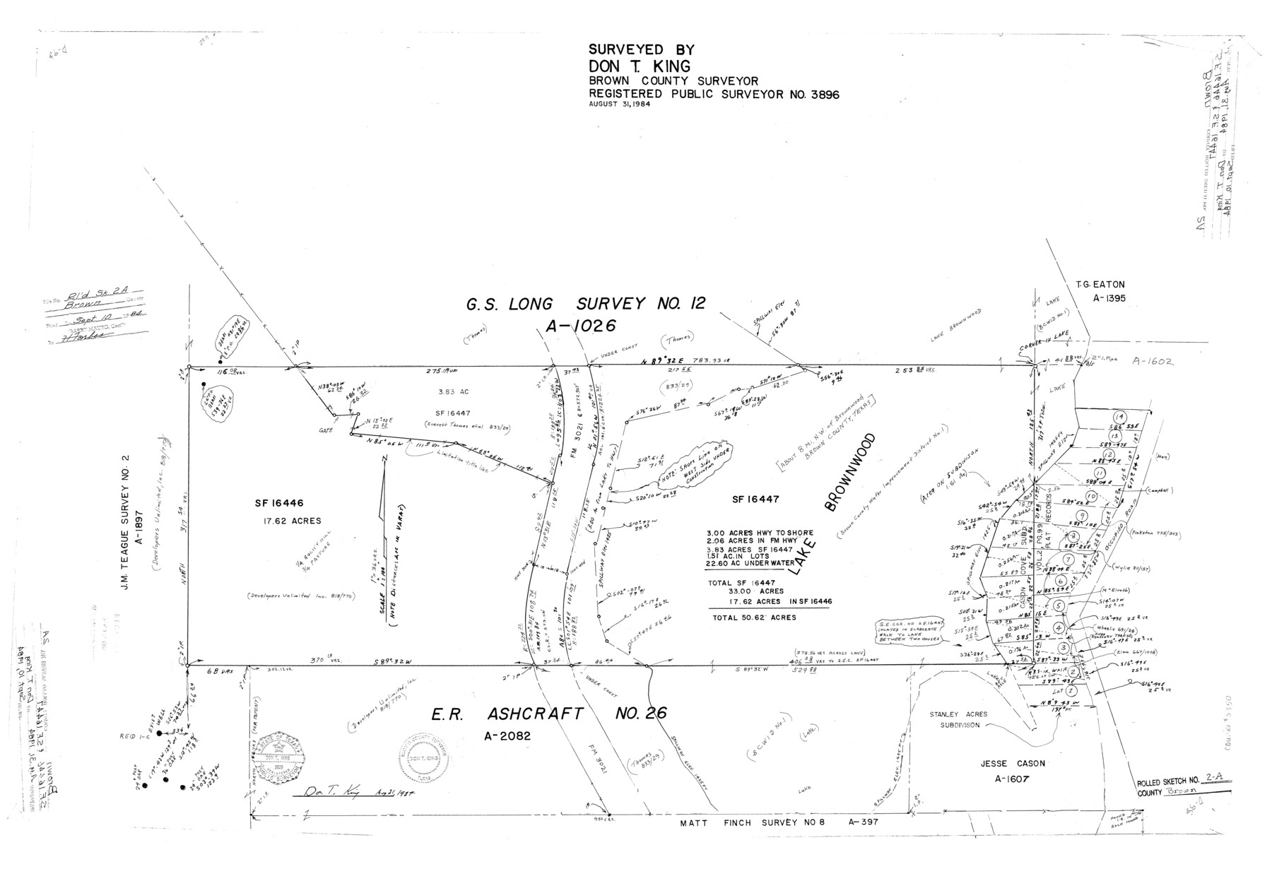
Brown County Rolled Sketch 2A
[Sketch relating to S.F. 16446 & S.F. 16447]
-
Map/Doc
5350
-
Collection
General Map Collection
-
Object Dates
1984/8/31 (Creation Date)
1984/9/10 (File Date)
-
People and Organizations
Don T. King (Surveyor/Engineer)
-
Counties
Brown
-
Subjects
Surveying Rolled Sketch
-
Height x Width
25.6 x 37.4 inches
65.0 x 95.0 cm
-
Medium
mylar, print
Part of: General Map Collection
Stonewall County Rolled Sketch 20

Print $40.00
- Digital $50.00
Stonewall County Rolled Sketch 20
1951
Size 30.1 x 55.4 inches
Map/Doc 63915
Edwards County Working Sketch 18

Print $20.00
- Digital $50.00
Edwards County Working Sketch 18
1931
Size 34.3 x 37.0 inches
Map/Doc 68894
Sabine County Working Sketch 3

Print $3.00
- Digital $50.00
Sabine County Working Sketch 3
1911
Size 10.8 x 15.7 inches
Map/Doc 63674
McLennan County Sketch File 40

Print $8.00
- Digital $50.00
McLennan County Sketch File 40
1950
Size 14.2 x 8.7 inches
Map/Doc 31315
Val Verde County Working Sketch 4

Print $20.00
- Digital $50.00
Val Verde County Working Sketch 4
1906
Size 23.9 x 17.3 inches
Map/Doc 72139
Nueces County Rolled Sketch 76

Print $20.00
- Digital $50.00
Nueces County Rolled Sketch 76
1981
Size 18.3 x 23.6 inches
Map/Doc 6937
Blanco County Sketch File 22

Print $4.00
- Digital $50.00
Blanco County Sketch File 22
1884
Size 8.7 x 15.5 inches
Map/Doc 14604
Hood County Working Sketch 8

Print $20.00
- Digital $50.00
Hood County Working Sketch 8
1971
Size 30.1 x 37.8 inches
Map/Doc 66202
Map of Hopkins County

Print $20.00
- Digital $50.00
Map of Hopkins County
1863
Size 22.6 x 24.1 inches
Map/Doc 3679
Kaufman County Sketch File 17

Print $4.00
- Digital $50.00
Kaufman County Sketch File 17
1873
Size 8.0 x 6.1 inches
Map/Doc 28657
Castro County Sketch File 1

Print $6.00
- Digital $50.00
Castro County Sketch File 1
1890
Size 8.8 x 7.8 inches
Map/Doc 17451
Galveston County NRC Article 33.136 Sketch 31

Print $22.00
- Digital $50.00
Galveston County NRC Article 33.136 Sketch 31
2005
Size 22.2 x 33.7 inches
Map/Doc 83280
You may also like
Right of Way and Track Map Texas & New Orleans R.R. Co. operated by the T. & N. O. R.R. Co. Dallas-Sabine Branch

Print $40.00
- Digital $50.00
Right of Way and Track Map Texas & New Orleans R.R. Co. operated by the T. & N. O. R.R. Co. Dallas-Sabine Branch
1918
Size 26.4 x 56.7 inches
Map/Doc 64157
[Sketch showing I. G. Yates SF 12341 and surrounding surveys]
![93106, [Sketch showing I. G. Yates SF 12341 and surrounding surveys], Twichell Survey Records](https://historictexasmaps.com/wmedia_w700/maps/93106-1.tif.jpg)
Print $20.00
- Digital $50.00
[Sketch showing I. G. Yates SF 12341 and surrounding surveys]
Size 25.9 x 21.6 inches
Map/Doc 93106
Map of the Property traversed by the Trinity & Sabine Railroad from Fortieth Mile to Ogden, Texas

Print $40.00
- Digital $50.00
Map of the Property traversed by the Trinity & Sabine Railroad from Fortieth Mile to Ogden, Texas
1882
Size 39.5 x 93.2 inches
Map/Doc 64046
Hutchinson County Rolled Sketch 18

Print $20.00
- Digital $50.00
Hutchinson County Rolled Sketch 18
Size 30.4 x 32.6 inches
Map/Doc 9244
Map of Cameron, Hidalgo and half of Starr County of Texas

Print $20.00
- Digital $50.00
Map of Cameron, Hidalgo and half of Starr County of Texas
1942
Size 42.1 x 29.6 inches
Map/Doc 60401
Jefferson County Rolled Sketch 9

Print $20.00
- Digital $50.00
Jefferson County Rolled Sketch 9
Size 36.6 x 47.0 inches
Map/Doc 9276
Frio County Working Sketch 8

Print $20.00
- Digital $50.00
Frio County Working Sketch 8
1948
Size 26.9 x 21.3 inches
Map/Doc 69282
Brewster County Rolled Sketch 42

Print $20.00
- Digital $50.00
Brewster County Rolled Sketch 42
1912
Size 18.5 x 43.3 inches
Map/Doc 5220
Swisher County Working Sketch 5

Print $20.00
- Digital $50.00
Swisher County Working Sketch 5
1973
Size 16.0 x 26.5 inches
Map/Doc 62416
Maps & Lists Showing Prison Lands (Oil & Gas) Leased as of June 1955

Digital $50.00
Maps & Lists Showing Prison Lands (Oil & Gas) Leased as of June 1955
Size 11.2 x 8.9 inches
Map/Doc 62875
Wilbarger County Working Sketch 2b

Print $20.00
- Digital $50.00
Wilbarger County Working Sketch 2b
1922
Size 19.8 x 20.0 inches
Map/Doc 72540
Hall County Sketch File 11

Print $12.00
- Digital $50.00
Hall County Sketch File 11
1884
Size 12.8 x 8.3 inches
Map/Doc 24808