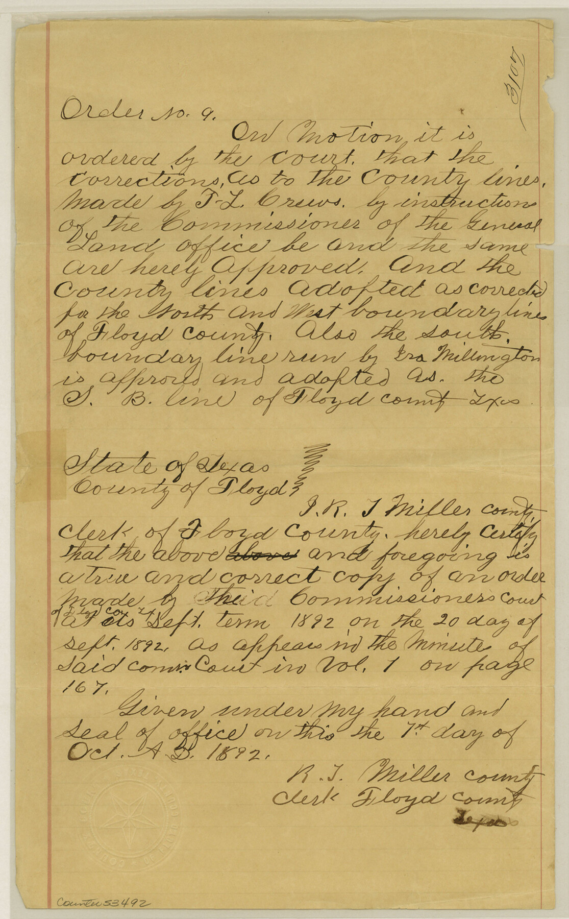
Floyd County Boundary File 3
Adoption by the Com'rs. Court of Corrections made by Mr. Crews Special Surveyor
-
Map/Doc
53492
-
Collection
General Map Collection
-
Counties
Floyd
-
Subjects
County Boundaries
-
Height x Width
14.4 x 8.9 inches
36.6 x 22.6 cm
Part of: General Map Collection
Sabine County Sketch File 6a

Print $4.00
Sabine County Sketch File 6a
1878
Size 8.1 x 12.5 inches
Map/Doc 35615
Medina County Working Sketch 19

Print $20.00
- Digital $50.00
Medina County Working Sketch 19
1980
Size 19.4 x 29.1 inches
Map/Doc 70934
Houston County Sketch File 24a

Print $20.00
- Digital $50.00
Houston County Sketch File 24a
1873
Size 26.3 x 21.0 inches
Map/Doc 11787
Crosby County Boundary File 4a

Print $30.00
- Digital $50.00
Crosby County Boundary File 4a
Size 8.8 x 32.8 inches
Map/Doc 52028
Shackelford County Sketch File 16

Print $24.00
- Digital $50.00
Shackelford County Sketch File 16
2005
Size 16.0 x 16.0 inches
Map/Doc 82982
Cameron County Rolled Sketch 32

Print $40.00
- Digital $50.00
Cameron County Rolled Sketch 32
1981
Size 136.6 x 18.1 inches
Map/Doc 8579
[Maps of surveys in Reeves & Culberson Cos]
![61143, [Maps of surveys in Reeves & Culberson Cos], General Map Collection](https://historictexasmaps.com/wmedia_w700/maps/61143.tif.jpg)
Print $20.00
- Digital $50.00
[Maps of surveys in Reeves & Culberson Cos]
1937
Size 30.7 x 24.9 inches
Map/Doc 61143
King County Working Sketch 9

Print $20.00
- Digital $50.00
King County Working Sketch 9
1955
Size 34.1 x 22.7 inches
Map/Doc 70173
Ellis County Working Sketch 5

Print $40.00
- Digital $50.00
Ellis County Working Sketch 5
1997
Size 49.2 x 32.4 inches
Map/Doc 69021
Young County Rolled Sketch 5

Print $20.00
- Digital $50.00
Young County Rolled Sketch 5
Size 20.2 x 26.1 inches
Map/Doc 8293
Webb County Sketch File 4-1

Print $6.00
- Digital $50.00
Webb County Sketch File 4-1
1874
Size 10.3 x 8.2 inches
Map/Doc 39722
Plat of Resurvey of Sections 1, 2, 3 and 4 T. 5S., R. 16W., of the Indian Meridian, Oklahoma

Print $4.00
- Digital $50.00
Plat of Resurvey of Sections 1, 2, 3 and 4 T. 5S., R. 16W., of the Indian Meridian, Oklahoma
1917
Size 18.3 x 24.1 inches
Map/Doc 75162
You may also like
Real County Working Sketch 39

Print $20.00
- Digital $50.00
Real County Working Sketch 39
1951
Size 33.5 x 36.6 inches
Map/Doc 71931
Shackelford County Boundary File 6

Print $6.00
- Digital $50.00
Shackelford County Boundary File 6
Size 11.4 x 8.8 inches
Map/Doc 58668
Jefferson County Sketch File 8

Print $8.00
- Digital $50.00
Jefferson County Sketch File 8
Size 8.0 x 7.6 inches
Map/Doc 28116
Part of City of Plains

Print $20.00
- Digital $50.00
Part of City of Plains
Size 37.1 x 23.6 inches
Map/Doc 92449
Sutton County Working Sketch 7

Print $20.00
- Digital $50.00
Sutton County Working Sketch 7
1972
Size 44.4 x 37.5 inches
Map/Doc 62350
Coryell County Sketch File 5

Print $40.00
- Digital $50.00
Coryell County Sketch File 5
1858
Size 16.0 x 12.7 inches
Map/Doc 19345
Anderson County Working Sketch 9

Print $20.00
- Digital $50.00
Anderson County Working Sketch 9
1929
Size 30.7 x 22.1 inches
Map/Doc 67008
Blanco County Sketch File 21b

Print $40.00
- Digital $50.00
Blanco County Sketch File 21b
1882
Size 16.9 x 17.8 inches
Map/Doc 10930
[Sketch of Surveys in Brooks County, Texas]
![10775, [Sketch of Surveys in Brooks County, Texas], Maddox Collection](https://historictexasmaps.com/wmedia_w700/maps/10775.tif.jpg)
Print $20.00
- Digital $50.00
[Sketch of Surveys in Brooks County, Texas]
Size 12.1 x 12.4 inches
Map/Doc 10775
General Highway Map, Foard County, Texas

Print $20.00
General Highway Map, Foard County, Texas
1961
Size 18.2 x 24.6 inches
Map/Doc 79468
Topographical Map of the Rio Grande, Sheet No. 9

Print $20.00
- Digital $50.00
Topographical Map of the Rio Grande, Sheet No. 9
1912
Map/Doc 89533
Mexico, Mittel-America, Texas

Print $20.00
- Digital $50.00
Mexico, Mittel-America, Texas
1850
Size 14.4 x 17.7 inches
Map/Doc 93710