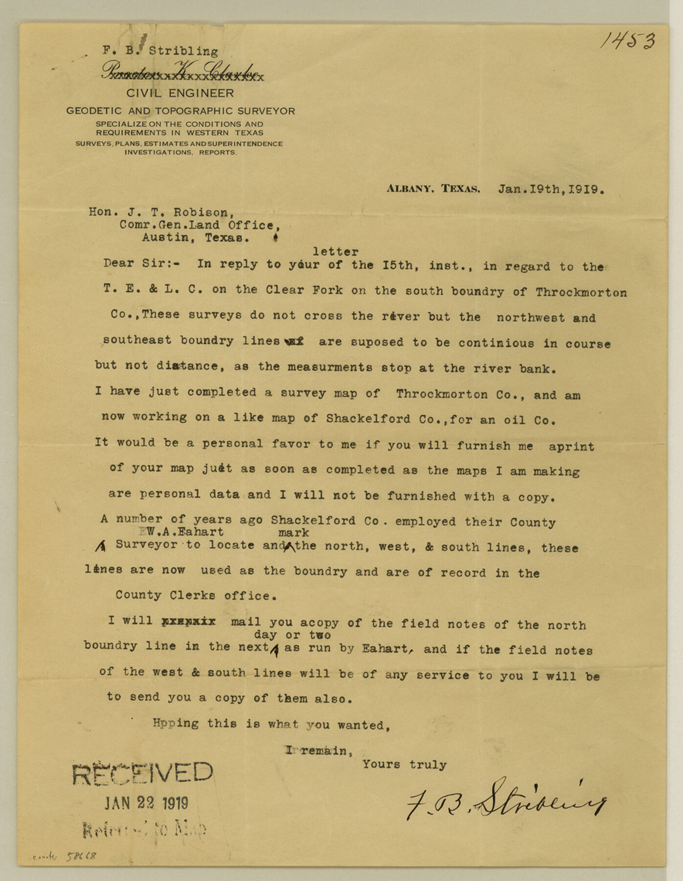
Shackelford County Boundary File 6
[Letter regarding Shackelford-Throckmorton County line; Letter containing summary of Fieldnotes of North line of Shackelford County]
-
Map/Doc
58668
-
Collection
General Map Collection
-
Counties
Shackelford
-
Subjects
County Boundaries
-
Height x Width
11.4 x 8.8 inches
29.0 x 22.4 cm
Part of: General Map Collection
Young County Sketch File 14

Print $20.00
- Digital $50.00
Young County Sketch File 14
1895
Size 10.9 x 27.3 inches
Map/Doc 12712
San Augustine County Sketch File 7

Print $4.00
San Augustine County Sketch File 7
1858
Size 7.0 x 8.2 inches
Map/Doc 35646
Zavala County

Print $20.00
- Digital $50.00
Zavala County
1915
Size 38.6 x 46.6 inches
Map/Doc 16940
Pecos County Rolled Sketch 135

Print $20.00
- Digital $50.00
Pecos County Rolled Sketch 135
Size 18.1 x 23.3 inches
Map/Doc 7271
Lamar County State Real Property Sketch 1

Print $20.00
- Digital $50.00
Lamar County State Real Property Sketch 1
2013
Size 24.0 x 36.0 inches
Map/Doc 93657
Anderson County Sketch File 9

Print $8.00
- Digital $50.00
Anderson County Sketch File 9
Size 12.5 x 8.2 inches
Map/Doc 12761
Wichita County

Print $20.00
- Digital $50.00
Wichita County
1971
Size 38.1 x 39.8 inches
Map/Doc 73323
Zapata County Rolled Sketch 10A

Print $20.00
- Digital $50.00
Zapata County Rolled Sketch 10A
1912
Size 26.3 x 26.5 inches
Map/Doc 8312
Brazoria County Sketch File 35

Print $40.00
- Digital $50.00
Brazoria County Sketch File 35
Size 15.5 x 18.4 inches
Map/Doc 10958
McCulloch County Rolled Sketch 11

Print $20.00
- Digital $50.00
McCulloch County Rolled Sketch 11
1992
Size 46.3 x 40.3 inches
Map/Doc 9499
Hays County Boundary File 3

Print $20.00
- Digital $50.00
Hays County Boundary File 3
Size 11.2 x 8.8 inches
Map/Doc 54597
Presidio County Working Sketch 147

Print $20.00
- Digital $50.00
Presidio County Working Sketch 147
Size 24.5 x 43.1 inches
Map/Doc 71825
You may also like
Gray County Boundary File 11

Print $80.00
- Digital $50.00
Gray County Boundary File 11
Size 20.7 x 19.7 inches
Map/Doc 53912
Kent County Boundary File 7

Print $6.00
- Digital $50.00
Kent County Boundary File 7
Size 10.8 x 8.7 inches
Map/Doc 55870

Refugio County

Print $20.00
- Digital $50.00
Refugio County
1883
Size 20.1 x 28.9 inches
Map/Doc 3984
Shackelford County Rolled Sketch 2

Print $40.00
- Digital $50.00
Shackelford County Rolled Sketch 2
Size 18.9 x 51.9 inches
Map/Doc 75935
Louisiana and Texas Intracoastal Waterway

Print $20.00
- Digital $50.00
Louisiana and Texas Intracoastal Waterway
1929
Size 13.7 x 19.0 inches
Map/Doc 83344
Flight Mission No. BRE-2P, Frame 105, Nueces County

Print $20.00
- Digital $50.00
Flight Mission No. BRE-2P, Frame 105, Nueces County
1956
Size 18.4 x 22.2 inches
Map/Doc 86790
Ector County Working Sketch 18

Print $20.00
- Digital $50.00
Ector County Working Sketch 18
1957
Size 42.0 x 39.1 inches
Map/Doc 68861
Donley County Working Sketch 7

Print $20.00
- Digital $50.00
Donley County Working Sketch 7
1971
Size 23.7 x 26.1 inches
Map/Doc 68740

El Paso County Rolled Sketch 52

Print $20.00
- Digital $50.00
El Paso County Rolled Sketch 52
1930
Size 18.5 x 24.4 inches
Map/Doc 5837
Val Verde County Working Sketch 114

Print $20.00
- Digital $50.00
Val Verde County Working Sketch 114
1993
Size 25.9 x 40.9 inches
Map/Doc 72249