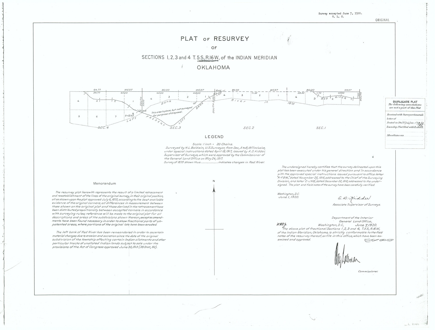
Plat of Resurvey of Sections 1, 2, 3 and 4 T. 5S., R. 16W., of the Indian Meridian, Oklahoma
-
Map/Doc
75162
-
Collection
General Map Collection
-
Object Dates
1917/12/8 (Creation Date)
-
Subjects
Texas Boundaries
-
Height x Width
18.3 x 24.1 inches
46.5 x 61.2 cm
Part of: General Map Collection
Matagorda County Working Sketch 9

Print $20.00
- Digital $50.00
Matagorda County Working Sketch 9
1954
Size 26.5 x 22.3 inches
Map/Doc 70867
Mason County Sketch File 1

Print $6.00
- Digital $50.00
Mason County Sketch File 1
1857
Size 11.0 x 8.2 inches
Map/Doc 30677
Presidio County Sketch File 105

Print $20.00
- Digital $50.00
Presidio County Sketch File 105
Size 13.1 x 20.6 inches
Map/Doc 82962
Jones County Sketch File 15

Print $40.00
- Digital $50.00
Jones County Sketch File 15
1892
Size 13.7 x 16.3 inches
Map/Doc 28503
Bell County Sketch File 20a

Print $4.00
- Digital $50.00
Bell County Sketch File 20a
1855
Size 6.7 x 8.3 inches
Map/Doc 14408
Hamilton County Sketch File 7

Print $40.00
- Digital $50.00
Hamilton County Sketch File 7
1860
Size 12.2 x 15.3 inches
Map/Doc 24912
Edwards County Boundary File 27 1/2a

Print $56.00
- Digital $50.00
Edwards County Boundary File 27 1/2a
Size 14.1 x 8.8 inches
Map/Doc 52922
Bailey County Sketch File 10

Print $4.00
- Digital $50.00
Bailey County Sketch File 10
Size 14.1 x 8.7 inches
Map/Doc 13965
Eastland County Boundary File 26

Print $24.00
- Digital $50.00
Eastland County Boundary File 26
Size 7.8 x 3.5 inches
Map/Doc 52801
Stonewall County Boundary File 4

Print $32.00
- Digital $50.00
Stonewall County Boundary File 4
Size 14.4 x 9.1 inches
Map/Doc 58977
Hale County Sketch File C

Print $20.00
- Digital $50.00
Hale County Sketch File C
1901
Size 20.1 x 24.1 inches
Map/Doc 11600
Dallam County Sketch File A

Print $20.00
- Digital $50.00
Dallam County Sketch File A
1903
Size 32.3 x 20.9 inches
Map/Doc 11281
You may also like
Wichita County Sketch File 6

Print $40.00
- Digital $50.00
Wichita County Sketch File 6
Size 12.3 x 12.2 inches
Map/Doc 40045
Comanche County Sketch File 1

Print $6.00
- Digital $50.00
Comanche County Sketch File 1
1847
Size 15.4 x 11.8 inches
Map/Doc 19051
Culberson County Sketch File 40

Print $6.00
- Digital $50.00
Culberson County Sketch File 40
Size 24.8 x 35.2 inches
Map/Doc 11275
Starr County Working Sketch 24

Print $20.00
- Digital $50.00
Starr County Working Sketch 24
1988
Size 37.1 x 20.2 inches
Map/Doc 63940
Smith County Sketch File 4

Print $4.00
- Digital $50.00
Smith County Sketch File 4
1853
Size 10.3 x 8.1 inches
Map/Doc 36752
Anderson County Sketch File 26

Print $40.00
- Digital $50.00
Anderson County Sketch File 26
1954
Size 22.7 x 17.4 inches
Map/Doc 10805
Irion County Rolled Sketch 7

Print $20.00
- Digital $50.00
Irion County Rolled Sketch 7
Size 43.9 x 33.8 inches
Map/Doc 9250
Menard County Working Sketch 11

Print $20.00
- Digital $50.00
Menard County Working Sketch 11
1939
Size 23.1 x 24.9 inches
Map/Doc 70958
Coleman County Rolled Sketch 7

Print $20.00
- Digital $50.00
Coleman County Rolled Sketch 7
Size 19.3 x 14.3 inches
Map/Doc 5530
Bell County Working Sketch 21

Print $20.00
- Digital $50.00
Bell County Working Sketch 21
2008
Size 41.0 x 29.5 inches
Map/Doc 88887
[Surveys along the Neches River in Jasper District]
![69733, [Surveys along the Neches River in Jasper District], General Map Collection](https://historictexasmaps.com/wmedia_w700/maps/69733.tif.jpg)
Print $2.00
- Digital $50.00
[Surveys along the Neches River in Jasper District]
1847
Size 9.2 x 6.8 inches
Map/Doc 69733
Starr County Working Sketch 22

Print $20.00
- Digital $50.00
Starr County Working Sketch 22
1983
Size 25.8 x 33.1 inches
Map/Doc 63938