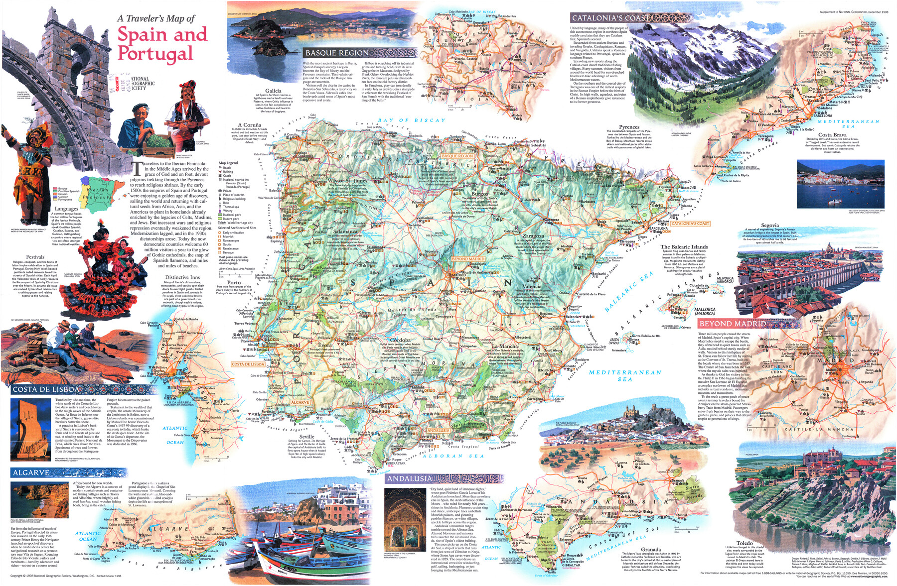
A Traveler's Map of Spain and Portugal
-
Map/Doc
95929
-
Collection
General Map Collection
-
Object Dates
1998 (Publication Date)
-
People and Organizations
National Geographic Society (Publisher)
Mark Lambert (Donor)
-
Subjects
Europe Pictorial
-
Height x Width
20.4 x 31.2 inches
51.8 x 79.3 cm
-
Medium
paper, print
-
Comments
For research only. Donated by Mark Lambert in August, 2020. See 95930 for verso.
Related maps

Part of: General Map Collection
Polk County Sketch File 30

Print $18.00
- Digital $50.00
Polk County Sketch File 30
1934
Size 14.1 x 8.5 inches
Map/Doc 34206
Parker County Working Sketch 25

Print $20.00
- Digital $50.00
Parker County Working Sketch 25
2008
Map/Doc 88836
Kinney County Working Sketch 23

Print $20.00
- Digital $50.00
Kinney County Working Sketch 23
1950
Size 20.8 x 24.3 inches
Map/Doc 70205
Madison County Working Sketch 8

Print $20.00
- Digital $50.00
Madison County Working Sketch 8
1982
Size 22.4 x 28.8 inches
Map/Doc 70770
Territory served by the Galveston Bay Ports, Tex.

Print $20.00
- Digital $50.00
Territory served by the Galveston Bay Ports, Tex.
Size 17.1 x 16.0 inches
Map/Doc 97165
Reagan County Rolled Sketch 29

Print $20.00
- Digital $50.00
Reagan County Rolled Sketch 29
1954
Size 35.6 x 35.4 inches
Map/Doc 9824
Wood County Boundary File 3

Print $10.00
- Digital $50.00
Wood County Boundary File 3
Size 12.4 x 8.5 inches
Map/Doc 60162
Culberson County Working Sketch 14

Print $20.00
- Digital $50.00
Culberson County Working Sketch 14
1923
Size 17.9 x 19.2 inches
Map/Doc 68466
Terrell County Working Sketch 44

Print $40.00
- Digital $50.00
Terrell County Working Sketch 44
1957
Size 40.0 x 71.4 inches
Map/Doc 62137
Uvalde County Rolled Sketch 7

Print $20.00
- Digital $50.00
Uvalde County Rolled Sketch 7
1946
Size 23.8 x 15.7 inches
Map/Doc 8092
Sterling County Sketch File 15

Print $8.00
- Digital $50.00
Sterling County Sketch File 15
1935
Size 11.1 x 8.8 inches
Map/Doc 37150
Jasper County Working Sketch 19

Print $20.00
- Digital $50.00
Jasper County Working Sketch 19
1939
Size 15.8 x 15.8 inches
Map/Doc 66481
You may also like
[East County Line]
![90225, [East County Line], Twichell Survey Records](https://historictexasmaps.com/wmedia_w700/maps/90225-1.tif.jpg)
Print $20.00
- Digital $50.00
[East County Line]
Size 38.2 x 11.7 inches
Map/Doc 90225
Flight Mission No. BRE-2P, Frame 78, Nueces County

Print $20.00
- Digital $50.00
Flight Mission No. BRE-2P, Frame 78, Nueces County
1956
Size 18.6 x 22.3 inches
Map/Doc 86773
Wichita County Working Sketch 13

Print $20.00
- Digital $50.00
Wichita County Working Sketch 13
1921
Size 16.5 x 32.8 inches
Map/Doc 72523
Starr County Sketch File 49

Print $20.00
- Digital $50.00
Starr County Sketch File 49
1951
Size 24.9 x 17.2 inches
Map/Doc 12346
Webb County Sketch File 4a

Print $8.00
- Digital $50.00
Webb County Sketch File 4a
1877
Size 11.6 x 4.0 inches
Map/Doc 39718
Brewster County Rolled Sketch 100

Print $133.00
- Digital $50.00
Brewster County Rolled Sketch 100
1893
Size 10.1 x 15.4 inches
Map/Doc 43055
Loving County

Print $20.00
- Digital $50.00
Loving County
1889
Size 24.7 x 20.1 inches
Map/Doc 91319
Erath County Working Sketch 32

Print $20.00
- Digital $50.00
Erath County Working Sketch 32
1971
Size 32.0 x 25.8 inches
Map/Doc 69113
Coleman County Sketch File 48

Print $29.00
- Digital $50.00
Coleman County Sketch File 48
1898
Size 8.2 x 12.7 inches
Map/Doc 18799
Howard County Rolled Sketch 12

Print $20.00
- Digital $50.00
Howard County Rolled Sketch 12
Size 25.8 x 16.5 inches
Map/Doc 6243
Sketch Showing Beach Groins 6th St to 39th St - Galveston, Tex.

Print $20.00
- Digital $50.00
Sketch Showing Beach Groins 6th St to 39th St - Galveston, Tex.
1928
Size 21.0 x 36.4 inches
Map/Doc 73626
Medina County Boundary File 3

Print $8.00
- Digital $50.00
Medina County Boundary File 3
Size 11.2 x 8.7 inches
Map/Doc 57031