Brewster County Rolled Sketch 114
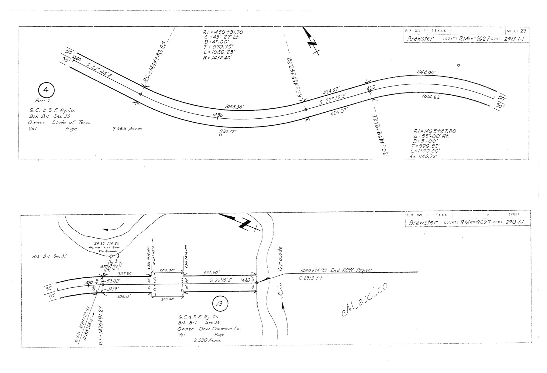
Plans of proposed State Highway Right of Way, RM Highway 2627, Brewster County, Control 2913-1-1 from: US 383, 38 mi. S of Marathon, SE to: Heath Crossing on Rio Grande (Sheet 28)
-
Map/Doc
5291
-
Collection
General Map Collection
-
Object Dates
1965/3/29 (File Date)
1964/12/3 (Creation Date)
-
People and Organizations
State Highway Department (Publisher)
-
Counties
Brewster
-
Subjects
Surveying Rolled Sketch
-
Height x Width
12.0 x 17.5 inches
30.5 x 44.5 cm
-
Medium
blueprint/diazo
-
Comments
This is one sheet of a set of 29 maps. For the complete set, see map numbers 5264-5292.
Related maps
Brewster County Rolled Sketch 114

Print $20.00
- Digital $50.00
Brewster County Rolled Sketch 114
1964
Size 11.8 x 18.5 inches
Map/Doc 5264
Brewster County Rolled Sketch 114

Print $20.00
- Digital $50.00
Brewster County Rolled Sketch 114
1964
Size 11.7 x 18.4 inches
Map/Doc 5265
Brewster County Rolled Sketch 114

Print $20.00
- Digital $50.00
Brewster County Rolled Sketch 114
1964
Size 11.7 x 18.6 inches
Map/Doc 5266
Brewster County Rolled Sketch 114

Print $20.00
- Digital $50.00
Brewster County Rolled Sketch 114
1964
Size 11.7 x 18.4 inches
Map/Doc 5267
Brewster County Rolled Sketch 114

Print $20.00
- Digital $50.00
Brewster County Rolled Sketch 114
1964
Size 23.8 x 18.9 inches
Map/Doc 5268
Brewster County Rolled Sketch 114

Print $20.00
- Digital $50.00
Brewster County Rolled Sketch 114
1964
Size 11.0 x 18.3 inches
Map/Doc 5269
Brewster County Rolled Sketch 114

Print $20.00
- Digital $50.00
Brewster County Rolled Sketch 114
1964
Size 11.1 x 18.4 inches
Map/Doc 5270
Brewster County Rolled Sketch 114

Print $20.00
- Digital $50.00
Brewster County Rolled Sketch 114
1964
Size 11.5 x 18.5 inches
Map/Doc 5271
Brewster County Rolled Sketch 114

Print $20.00
- Digital $50.00
Brewster County Rolled Sketch 114
1964
Size 11.6 x 18.3 inches
Map/Doc 5272
Brewster County Rolled Sketch 114

Print $20.00
- Digital $50.00
Brewster County Rolled Sketch 114
1964
Size 11.6 x 17.3 inches
Map/Doc 5273
Brewster County Rolled Sketch 114

Print $20.00
- Digital $50.00
Brewster County Rolled Sketch 114
1964
Size 11.5 x 17.6 inches
Map/Doc 5274
Brewster County Rolled Sketch 114

Print $20.00
- Digital $50.00
Brewster County Rolled Sketch 114
1964
Size 11.6 x 18.5 inches
Map/Doc 5275
Brewster County Rolled Sketch 114

Print $20.00
- Digital $50.00
Brewster County Rolled Sketch 114
1964
Size 11.7 x 18.3 inches
Map/Doc 5276
Brewster County Rolled Sketch 114

Print $20.00
- Digital $50.00
Brewster County Rolled Sketch 114
1964
Size 11.4 x 18.4 inches
Map/Doc 5277
Brewster County Rolled Sketch 114

Print $20.00
- Digital $50.00
Brewster County Rolled Sketch 114
1964
Size 12.0 x 18.4 inches
Map/Doc 5278
Brewster County Rolled Sketch 114

Print $20.00
- Digital $50.00
Brewster County Rolled Sketch 114
1964
Size 11.9 x 18.4 inches
Map/Doc 5279
Brewster County Rolled Sketch 114

Print $20.00
- Digital $50.00
Brewster County Rolled Sketch 114
1964
Size 11.9 x 18.3 inches
Map/Doc 5280
Brewster County Rolled Sketch 114

Print $20.00
- Digital $50.00
Brewster County Rolled Sketch 114
1964
Size 11.7 x 17.7 inches
Map/Doc 5281
Brewster County Rolled Sketch 114

Print $20.00
- Digital $50.00
Brewster County Rolled Sketch 114
1964
Size 11.4 x 18.2 inches
Map/Doc 5282
Brewster County Rolled Sketch 114

Print $20.00
- Digital $50.00
Brewster County Rolled Sketch 114
1964
Size 12.2 x 17.5 inches
Map/Doc 5283
Part of: General Map Collection
Brewster County Sketch File 24

Print $40.00
- Digital $50.00
Brewster County Sketch File 24
1957
Size 14.3 x 15.5 inches
Map/Doc 15831
Dimmit County Working Sketch 49

Print $40.00
- Digital $50.00
Dimmit County Working Sketch 49
1980
Size 78.8 x 44.7 inches
Map/Doc 68710
Jasper County Working Sketch 32

Print $20.00
- Digital $50.00
Jasper County Working Sketch 32
1993
Size 18.7 x 22.7 inches
Map/Doc 66494
Schleicher County Sketch File 42

Print $40.00
- Digital $50.00
Schleicher County Sketch File 42
1963
Size 16.3 x 14.4 inches
Map/Doc 36546
Uvalde County Working Sketch 55

Print $20.00
- Digital $50.00
Uvalde County Working Sketch 55
1983
Size 38.9 x 37.6 inches
Map/Doc 72125
La Salle County Working Sketch 26

Print $20.00
- Digital $50.00
La Salle County Working Sketch 26
1949
Size 28.2 x 16.3 inches
Map/Doc 70327
Rio Grande Rectification Project, El Paso and Juarez Valley

Print $20.00
- Digital $50.00
Rio Grande Rectification Project, El Paso and Juarez Valley
1935
Size 10.9 x 29.7 inches
Map/Doc 60860
Upshur County Sketch File 8

Print $22.00
- Digital $50.00
Upshur County Sketch File 8
1857
Size 20.4 x 8.2 inches
Map/Doc 38746
Scurry County Rolled Sketch 14

Print $20.00
- Digital $50.00
Scurry County Rolled Sketch 14
2016
Size 23.4 x 41.4 inches
Map/Doc 95404
Chambers County Working Sketch 16

Print $20.00
- Digital $50.00
Chambers County Working Sketch 16
1961
Size 32.8 x 30.4 inches
Map/Doc 67999
Polk County Sketch File 29

Print $4.00
- Digital $50.00
Polk County Sketch File 29
Size 8.8 x 12.6 inches
Map/Doc 34200
Bosque County Sketch File 32

Print $42.00
- Digital $50.00
Bosque County Sketch File 32
1944
Size 19.6 x 18.6 inches
Map/Doc 10938
You may also like
Abandoned and Canceled Surveys - Volume 3 of 3, Counties L-Z

Abandoned and Canceled Surveys - Volume 3 of 3, Counties L-Z
Map/Doc 83250
Hockley County Boundary File 6

Print $446.00
- Digital $50.00
Hockley County Boundary File 6
Size 3.1 x 5.1 inches
Map/Doc 54832
[Sketch of expeditions, trails in Jones, Taylor, Shackelford, Callahan, Buchanan/Stephens and Eastland Counties]
![65406, [Sketch of expeditions, trails in Jones, Taylor, Shackelford, Callahan, Buchanan/Stephens and Eastland Counties], General Map Collection](https://historictexasmaps.com/wmedia_w700/maps/65406.tif.jpg)
Print $4.00
- Digital $50.00
[Sketch of expeditions, trails in Jones, Taylor, Shackelford, Callahan, Buchanan/Stephens and Eastland Counties]
1873
Size 10.7 x 18.1 inches
Map/Doc 65406
Flight Mission No. CRC-3R, Frame 201, Chambers County

Print $20.00
- Digital $50.00
Flight Mission No. CRC-3R, Frame 201, Chambers County
1956
Size 18.6 x 22.4 inches
Map/Doc 84856
Dimmit County Boundary File 5

Print $6.00
- Digital $50.00
Dimmit County Boundary File 5
Size 11.1 x 8.6 inches
Map/Doc 52577
Sutton County Sketch File 3

Print $8.00
- Digital $50.00
Sutton County Sketch File 3
Size 12.9 x 8.5 inches
Map/Doc 37353
Maverick County Working Sketch 4

Print $40.00
- Digital $50.00
Maverick County Working Sketch 4
1944
Size 51.3 x 30.7 inches
Map/Doc 70896
Matagorda County Working Sketch 7

Print $20.00
- Digital $50.00
Matagorda County Working Sketch 7
1953
Size 41.0 x 31.8 inches
Map/Doc 70865
Rusk County Rolled Sketch 9A

Print $20.00
- Digital $50.00
Rusk County Rolled Sketch 9A
1971
Size 30.4 x 19.1 inches
Map/Doc 7547
America's Fun-Tier: Texas 1967 Official State Highway Map

Digital $50.00
America's Fun-Tier: Texas 1967 Official State Highway Map
Size 28.3 x 36.6 inches
Map/Doc 94322

Bosque County Working Sketch 13

Print $20.00
- Digital $50.00
Bosque County Working Sketch 13
1957
Size 17.2 x 14.5 inches
Map/Doc 67446