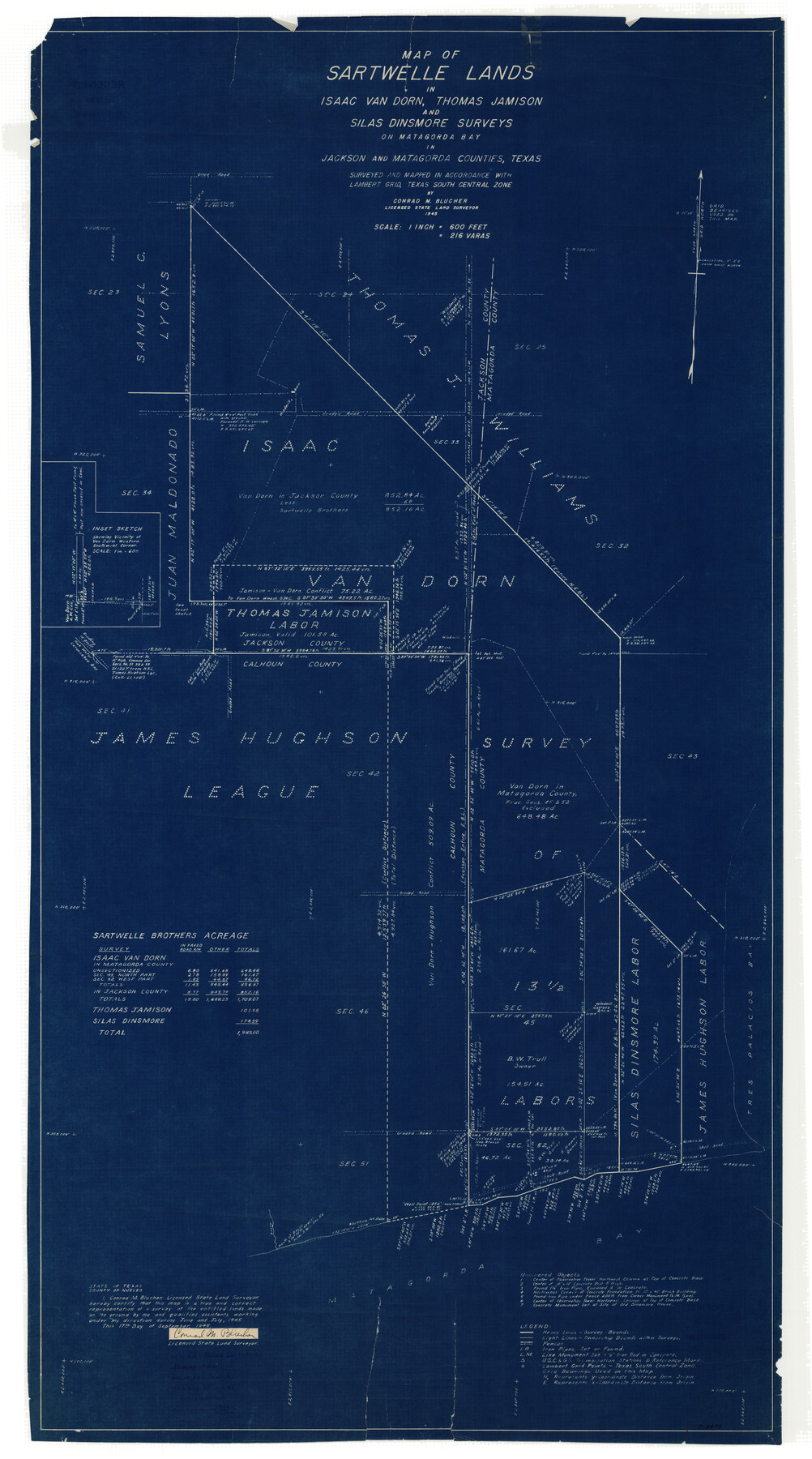
Matagorda County Rolled Sketch 24
Map of Sartwelle Lands in Isaac Van Dorn, Thomas Jamison, and Silas Dinsmore surveys on Matagorda Bay in Jackson and Matagorda Counties, Texas
- 
                          Map/Doc
9478
 - 
                            Collection
General Map Collection
 - 
                            Object Dates
1945/9/17 (Creation Date)
1947/7/25 (File Date)
 - 
                            People and Organizations
Conrad M. Blucher (Surveyor/Engineer)
 - 
                            Counties
Matagorda
 - 
                            Subjects
Surveying Rolled Sketch
 - 
                            Height x Width
53.2 x 29.6 inches
135.1 x 75.2 cm
 - 
                            Medium
blueprint/diazo
 - 
                            Scale
1" = 216 varas
 
Part of: General Map Collection
            G. C. & S. F. Ry., San Saba Branch, Right of Way Map, Brady to Melvin


                                            Print $40.00                    
                                             -                         Digital $50.00                                    
                G. C. & S. F. Ry., San Saba Branch, Right of Way Map, Brady to Melvin
1916
Size 38.2 x 122.0 inches
                                Map/Doc 61420
            
            Hemphill County Working Sketch 38


                                            Print $20.00                    
                                             -                         Digital $50.00                                    
                Hemphill County Working Sketch 38
1982
Size 29.9 x 27.8 inches
                                Map/Doc 66133
            
            Randall County Rolled Sketch 7


                                            Print $20.00                    
                                             -                         Digital $50.00                                    
                Randall County Rolled Sketch 7
1949
Size 18.9 x 22.1 inches
                                Map/Doc 7427
            
            Cooke County Sketch File 25


                                            Print $4.00                    
                                             -                         Digital $50.00                                    
                Cooke County Sketch File 25
1872
Size 8.2 x 6.8 inches
                                Map/Doc 19275
            
            Map of Runnels County


                                            Print $20.00                    
                                             -                         Digital $50.00                                    
                Map of Runnels County
1858
Size 24.7 x 25.6 inches
                                Map/Doc 4004
            
            Duval County Working Sketch 26


                                            Print $20.00                    
                                             -                         Digital $50.00                                    
                Duval County Working Sketch 26
1947
Size 34.8 x 36.9 inches
                                Map/Doc 68750
            
            Val Verde County Working Sketch 100


                                            Print $20.00                    
                                             -                         Digital $50.00                                    
                Val Verde County Working Sketch 100
1981
Size 22.3 x 32.0 inches
                                Map/Doc 72235
            
            Edwards County Working Sketch 111


                                            Print $40.00                    
                                             -                         Digital $50.00                                    
                Edwards County Working Sketch 111
1972
Size 58.1 x 30.8 inches
                                Map/Doc 68987
            
            Sterling County Rolled Sketch 25


                                            Print $20.00                    
                                             -                         Digital $50.00                                    
                Sterling County Rolled Sketch 25
Size 31.4 x 35.3 inches
                                Map/Doc 9955
            
            Outer Continental Shelf Leasing Maps (Texas Offshore Operations)


                                            Print $20.00                    
                                             -                         Digital $50.00                                    
                Outer Continental Shelf Leasing Maps (Texas Offshore Operations)
Size 19.4 x 18.5 inches
                                Map/Doc 75849
            
            Matagorda Bay Including Lavaca and Tres Palacios Bays


                                            Print $20.00                    
                                             -                         Digital $50.00                                    
                Matagorda Bay Including Lavaca and Tres Palacios Bays
1975
Size 37.2 x 47.7 inches
                                Map/Doc 73364
            
            Shelby County Sketch File 16


                                            Print $6.00                    
                                             -                         Digital $50.00                                    
                Shelby County Sketch File 16
1873
Size 8.2 x 8.6 inches
                                Map/Doc 36626
            You may also like
            Brewster County Sketch File NS-14


                                            Print $160.00                    
                                             -                         Digital $50.00                                    
                Brewster County Sketch File NS-14
1970
Size 8.2 x 6.5 inches
                                Map/Doc 16224
            
            Gaines County Working Sketch 32


                                            Print $20.00                    
                                             -                         Digital $50.00                                    
                Gaines County Working Sketch 32
1990
Size 38.3 x 26.3 inches
                                Map/Doc 69332
            
            Smith County Working Sketch 14


                                            Print $40.00                    
                                             -                         Digital $50.00                                    
                Smith County Working Sketch 14
1966
Size 34.9 x 49.2 inches
                                Map/Doc 63899
            
            General Highway Map, Taylor County, Texas


                                            Print $20.00                    
                                    
                General Highway Map, Taylor County, Texas
1940
Size 18.6 x 25.0 inches
                                Map/Doc 79254
            
            Outer Continental Shelf Leasing Maps (Texas Offshore Operations)


                                            Print $20.00                    
                                             -                         Digital $50.00                                    
                Outer Continental Shelf Leasing Maps (Texas Offshore Operations)
Size 17.7 x 14.1 inches
                                Map/Doc 75855
            
            Brazoria County Sketch File 31


                                            Print $40.00                    
                                             -                         Digital $50.00                                    
                Brazoria County Sketch File 31
1894
Size 17.4 x 14.4 inches
                                Map/Doc 15039
            
            District Map Showing Deaf Smith, Randall, Armstrong, Donley, Collingsworth, Castro, Swisher, Briscoe, Hall & Childress Counties, Texas


                                            Print $40.00                    
                                             -                         Digital $50.00                                    
                District Map Showing Deaf Smith, Randall, Armstrong, Donley, Collingsworth, Castro, Swisher, Briscoe, Hall & Childress Counties, Texas
1878
Size 42.9 x 82.3 inches
                                Map/Doc 1994
            
            Garza County Boundary File 2a


                                            Print $8.00                    
                                             -                         Digital $50.00                                    
                Garza County Boundary File 2a
Size 14.4 x 8.9 inches
                                Map/Doc 53675
            
            Threading the Islands: Which track fits?


            Threading the Islands: Which track fits?
1986
Size 20.5 x 14.7 inches
                                Map/Doc 96838
            
            Township 1 North Range 11 West, North Western District, Louisiana


                                            Print $20.00                    
                                             -                         Digital $50.00                                    
                Township 1 North Range 11 West, North Western District, Louisiana
1884
Size 19.6 x 24.7 inches
                                Map/Doc 65878
            
            Travis County Rolled Sketch 3


                                            Print $40.00                    
                                             -                         Digital $50.00                                    
                Travis County Rolled Sketch 3
1902
Size 37.2 x 48.0 inches
                                Map/Doc 10009
            
            Map of the Mexican Central Railway and Connections


                                            Print $20.00                    
                                             -                         Digital $50.00                                    
                Map of the Mexican Central Railway and Connections
Size 22.0 x 26.0 inches
                                Map/Doc 95742