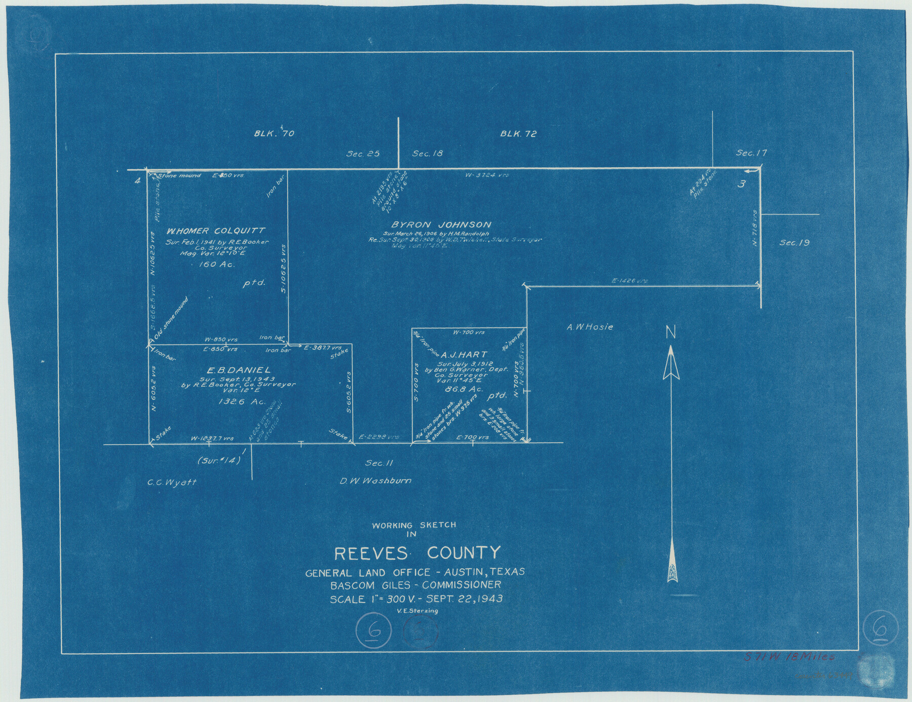
Reeves County Working Sketch 6
-
Map/Doc
63449
-
Collection
General Map Collection
-
Object Dates
9/22/1943 (Creation Date)
-
People and Organizations
Victor E. Sterzing (Draftsman)
-
Counties
Reeves
-
Subjects
Surveying Working Sketch
-
Height x Width
14.1 x 18.4 inches
35.8 x 46.7 cm
-
Scale
1" = 300 varas
Part of: General Map Collection
Kaufman County Boundary File 6a

Print $6.00
- Digital $50.00
Kaufman County Boundary File 6a
Size 14.0 x 8.5 inches
Map/Doc 55963
Harris County Rolled Sketch 96C

Print $3.00
- Digital $50.00
Harris County Rolled Sketch 96C
Size 10.5 x 10.5 inches
Map/Doc 10653
Pecos County Working Sketch 133

Print $20.00
- Digital $50.00
Pecos County Working Sketch 133
1979
Size 44.0 x 37.2 inches
Map/Doc 71607
Donley County Sketch File 20 (6a)

Print $20.00
- Digital $50.00
Donley County Sketch File 20 (6a)
Size 20.1 x 13.1 inches
Map/Doc 11367
Fort Bend County Sketch File 5

Print $4.00
- Digital $50.00
Fort Bend County Sketch File 5
Size 8.2 x 13.0 inches
Map/Doc 22889
Tarrant County Sketch File 3

Print $4.00
- Digital $50.00
Tarrant County Sketch File 3
Size 11.8 x 8.2 inches
Map/Doc 37676
Pecos County Working Sketch 40

Print $20.00
- Digital $50.00
Pecos County Working Sketch 40
1941
Size 29.9 x 39.7 inches
Map/Doc 71512
Freestone County Working Sketch 34

Print $40.00
- Digital $50.00
Freestone County Working Sketch 34
2011
Size 36.5 x 59.2 inches
Map/Doc 90095
Galveston County Sketch File 8

Print $4.00
- Digital $50.00
Galveston County Sketch File 8
1862
Size 11.2 x 8.8 inches
Map/Doc 23365
Presidio County Working Sketch 142

Print $20.00
- Digital $50.00
Presidio County Working Sketch 142
1990
Size 24.5 x 21.7 inches
Map/Doc 71820
Fisher County Working Sketch 14

Print $20.00
- Digital $50.00
Fisher County Working Sketch 14
1957
Size 24.9 x 33.1 inches
Map/Doc 69148
Railroad and County Map of Texas

Print $20.00
- Digital $50.00
Railroad and County Map of Texas
1926
Size 42.9 x 45.2 inches
Map/Doc 65799
You may also like
Marion County Boundary File 2

Print $6.00
- Digital $50.00
Marion County Boundary File 2
Size 11.2 x 8.7 inches
Map/Doc 56818
Motley County Sketch File 2 (N)

Print $22.00
- Digital $50.00
Motley County Sketch File 2 (N)
Size 8.3 x 14.8 inches
Map/Doc 31996
[Blocks K5-K7]
![90538, [Blocks K5-K7], Twichell Survey Records](https://historictexasmaps.com/wmedia_w700/maps/90538-1.tif.jpg)
Print $3.00
- Digital $50.00
[Blocks K5-K7]
1902
Size 12.5 x 11.5 inches
Map/Doc 90538
[Surveys South of the Levi Jordan Title, Southwest of the Neches River]
![90424, [Surveys South of the Levi Jordan Title, Southwest of the Neches River], Twichell Survey Records](https://historictexasmaps.com/wmedia_w700/maps/90424-1.tif.jpg)
Print $20.00
- Digital $50.00
[Surveys South of the Levi Jordan Title, Southwest of the Neches River]
Size 33.4 x 43.3 inches
Map/Doc 90424
Map No. 1 - Rio Bravo del Norte section of boundary between the United States & Mexico agreed upon by the Joint Commission under the Treaty of Guadalupe Hidalgo

Print $20.00
- Digital $50.00
Map No. 1 - Rio Bravo del Norte section of boundary between the United States & Mexico agreed upon by the Joint Commission under the Treaty of Guadalupe Hidalgo
1852
Size 18.2 x 27.2 inches
Map/Doc 72865
Sherman County

Print $20.00
- Digital $50.00
Sherman County
1932
Size 39.6 x 36.4 inches
Map/Doc 77422
Outer Continental Shelf Leasing Maps (Texas Offshore Operations)

Print $20.00
- Digital $50.00
Outer Continental Shelf Leasing Maps (Texas Offshore Operations)
Size 13.4 x 19.8 inches
Map/Doc 75846
[Sections 58 through 95]
![92478, [Sections 58 through 95], Twichell Survey Records](https://historictexasmaps.com/wmedia_w700/maps/92478-1.tif.jpg)
Print $20.00
- Digital $50.00
[Sections 58 through 95]
Size 23.9 x 19.5 inches
Map/Doc 92478
Topographical Map of the Rio Grande, Sheet No. 28

Print $20.00
- Digital $50.00
Topographical Map of the Rio Grande, Sheet No. 28
1912
Map/Doc 89552

Flight Mission No. DAG-21K, Frame 36, Matagorda County

Print $20.00
- Digital $50.00
Flight Mission No. DAG-21K, Frame 36, Matagorda County
1952
Size 18.5 x 22.3 inches
Map/Doc 86403
Jasper County Rolled Sketch 7A

Print $20.00
- Digital $50.00
Jasper County Rolled Sketch 7A
Size 22.4 x 14.7 inches
Map/Doc 6354