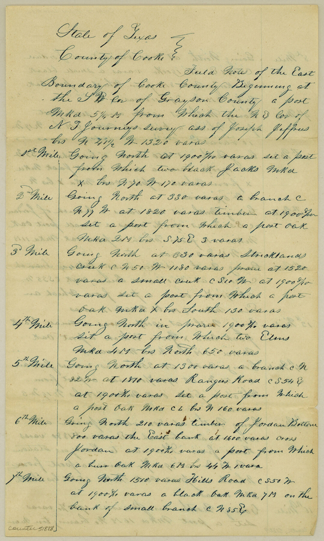
Cooke County Boundary File 1a
[Fieldnotes of the East Boundary line of Cooke County]
-
Map/Doc
51828
-
Collection
General Map Collection
-
Counties
Cooke
-
Subjects
County Boundaries
-
Height x Width
12.6 x 7.5 inches
32.0 x 19.1 cm
Part of: General Map Collection
Part of Laguna Madre in Cameron County, showing Subdivision for Mineral Development

Print $20.00
- Digital $50.00
Part of Laguna Madre in Cameron County, showing Subdivision for Mineral Development
1953
Size 33.0 x 21.9 inches
Map/Doc 1927
Jack County Sketch File 26

Print $4.00
- Digital $50.00
Jack County Sketch File 26
1891
Size 8.7 x 9.3 inches
Map/Doc 27563

Nacogdoches County

Print $20.00
- Digital $50.00
Nacogdoches County
1950
Size 47.0 x 43.1 inches
Map/Doc 73248
Connected Map of the County of Victoria

Print $40.00
- Digital $50.00
Connected Map of the County of Victoria
1838
Size 79.7 x 49.0 inches
Map/Doc 1946
Jeff Davis County Working Sketch 33

Print $40.00
- Digital $50.00
Jeff Davis County Working Sketch 33
1977
Size 28.8 x 48.3 inches
Map/Doc 66528
Stephens County Sketch File 16

Print $40.00
- Digital $50.00
Stephens County Sketch File 16
Size 38.2 x 72.1 inches
Map/Doc 10608
Abandoned and Canceled Surveys - Volume 1 of 3, Counties A-D

Abandoned and Canceled Surveys - Volume 1 of 3, Counties A-D
Map/Doc 83248
Brewster County Rolled Sketch 114

Print $20.00
- Digital $50.00
Brewster County Rolled Sketch 114
1964
Size 11.4 x 18.2 inches
Map/Doc 5282
Randall County Rolled Sketch 9B

Print $20.00
- Digital $50.00
Randall County Rolled Sketch 9B
1985
Size 45.0 x 34.5 inches
Map/Doc 9810
Angelina County Working Sketch 22a

Print $20.00
- Digital $50.00
Angelina County Working Sketch 22a
1953
Size 22.3 x 20.1 inches
Map/Doc 67103
Right of Way and Track Map, The Missouri, Kansas and Texas Ry. of Texas operated by the Missouri, Kansas and Texas Ry. of Texas, Henrietta Division

Print $40.00
- Digital $50.00
Right of Way and Track Map, The Missouri, Kansas and Texas Ry. of Texas operated by the Missouri, Kansas and Texas Ry. of Texas, Henrietta Division
1918
Size 25.1 x 56.4 inches
Map/Doc 64074
You may also like
Randall County Rolled Sketch 8

Print $20.00
- Digital $50.00
Randall County Rolled Sketch 8
Size 32.9 x 40.6 inches
Map/Doc 7429
Kendall County Sketch File 28

Print $12.00
- Digital $50.00
Kendall County Sketch File 28
1953
Size 14.3 x 8.9 inches
Map/Doc 28733
Ellis County Sketch File 13

Print $40.00
- Digital $50.00
Ellis County Sketch File 13
1860
Size 12.6 x 16.0 inches
Map/Doc 21852
Galveston County Sketch File 51

Print $20.00
- Digital $50.00
Galveston County Sketch File 51
1895
Size 25.7 x 40.2 inches
Map/Doc 10457
Map of Winkler County

Print $20.00
- Digital $50.00
Map of Winkler County
1900
Size 42.4 x 38.6 inches
Map/Doc 16931
South Part Crockett County

Print $20.00
- Digital $50.00
South Part Crockett County
1977
Size 30.6 x 40.1 inches
Map/Doc 77254
Flight Mission No. BRA-7M, Frame 191, Jefferson County

Print $20.00
- Digital $50.00
Flight Mission No. BRA-7M, Frame 191, Jefferson County
1953
Size 18.6 x 22.4 inches
Map/Doc 85559
Baylor County Working Sketch 14

Print $40.00
- Digital $50.00
Baylor County Working Sketch 14
1982
Size 33.5 x 55.1 inches
Map/Doc 67299
Upton County Working Sketch 19

Print $40.00
- Digital $50.00
Upton County Working Sketch 19
1949
Size 51.7 x 43.3 inches
Map/Doc 69515
[North Central Part of County]
![90555, [North Central Part of County], Twichell Survey Records](https://historictexasmaps.com/wmedia_w700/maps/90555-1.tif.jpg)
Print $2.00
- Digital $50.00
[North Central Part of County]
Size 6.7 x 9.9 inches
Map/Doc 90555
Swisher County

Print $20.00
- Digital $50.00
Swisher County
1879
Size 20.9 x 18.7 inches
Map/Doc 4063
Louisiana and Texas Intracoastal Waterway

Print $20.00
- Digital $50.00
Louisiana and Texas Intracoastal Waterway
1929
Size 13.9 x 19.3 inches
Map/Doc 83343