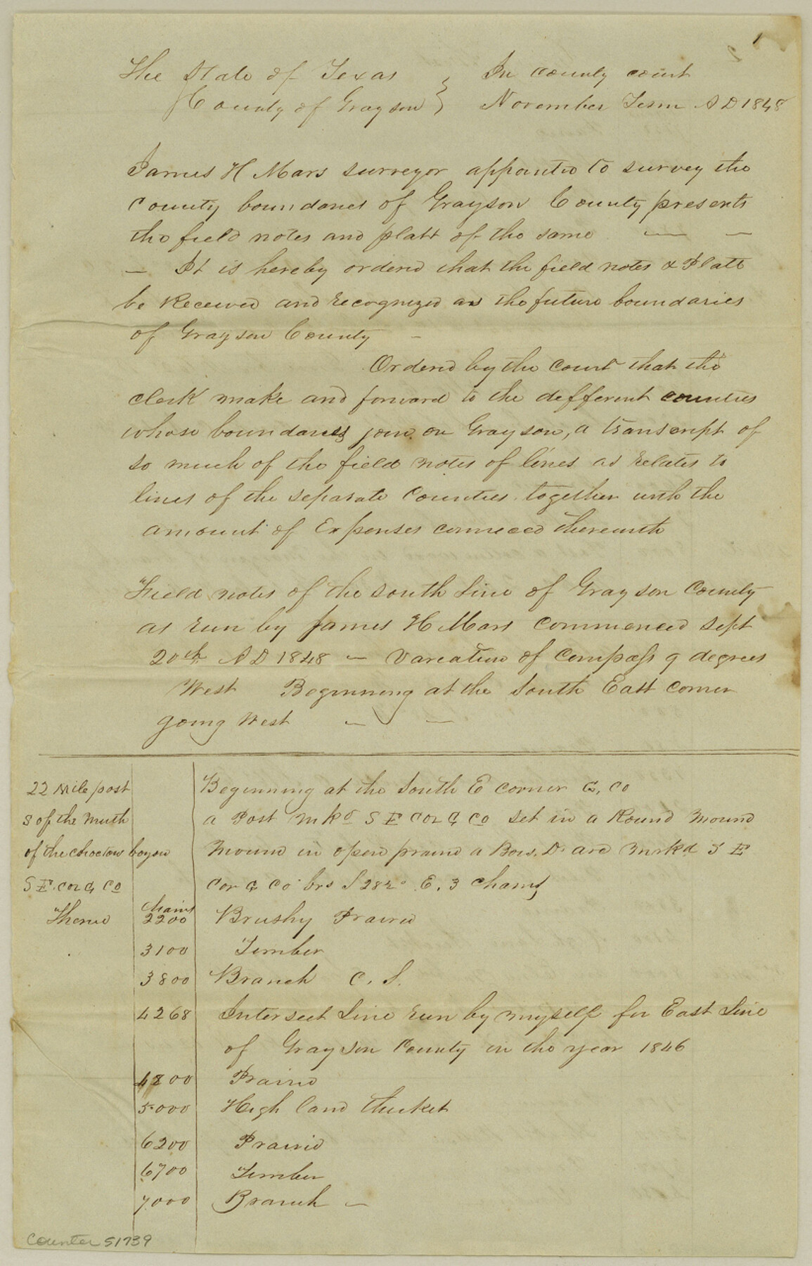
Collin County Boundary File 18d
[Fieldnotes of the County Boundaries between Collin and Grayson Counties]
-
Map/Doc
51739
-
Collection
General Map Collection
-
Counties
Collin
-
Subjects
County Boundaries
-
Height x Width
12.8 x 8.2 inches
32.5 x 20.8 cm
Part of: General Map Collection
Hemphill County Working Sketch 25

Print $40.00
- Digital $50.00
Hemphill County Working Sketch 25
1974
Size 44.0 x 60.7 inches
Map/Doc 66120
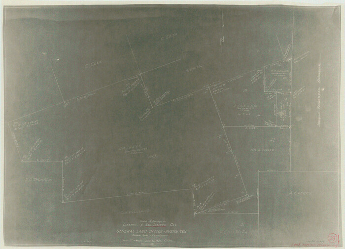
San Jacinto County Working Sketch 29
Print $20.00
- Digital $50.00
San Jacinto County Working Sketch 29
1950
Size 17.6 x 24.4 inches
Map/Doc 63742
Hudspeth County Working Sketch 18

Print $40.00
- Digital $50.00
Hudspeth County Working Sketch 18
1957
Size 22.2 x 113.1 inches
Map/Doc 66300
Amistad International Reservoir on Rio Grande 78

Print $20.00
- Digital $50.00
Amistad International Reservoir on Rio Grande 78
1949
Size 28.5 x 40.2 inches
Map/Doc 75506
Glasscock County Rolled Sketch 1

Print $20.00
- Digital $50.00
Glasscock County Rolled Sketch 1
1906
Size 37.3 x 33.6 inches
Map/Doc 9055
Presidio County Sketch File 35A

Print $20.00
- Digital $50.00
Presidio County Sketch File 35A
1906
Size 12.5 x 20.9 inches
Map/Doc 11713
Stonewall County Working Sketch 16

Print $20.00
- Digital $50.00
Stonewall County Working Sketch 16
1954
Size 39.2 x 29.7 inches
Map/Doc 62323
Belton and Stillhouse Hollow Reservoirs (Recto)

Belton and Stillhouse Hollow Reservoirs (Recto)
1972
Size 29.1 x 22.6 inches
Map/Doc 94172
Pecos County Working Sketch 42

Print $20.00
- Digital $50.00
Pecos County Working Sketch 42
1942
Size 31.3 x 23.9 inches
Map/Doc 71514
Walker County Sketch File 3

Print $4.00
- Digital $50.00
Walker County Sketch File 3
1853
Size 12.8 x 8.2 inches
Map/Doc 39551
Flight Mission No. DQO-8K, Frame 54, Galveston County

Print $20.00
- Digital $50.00
Flight Mission No. DQO-8K, Frame 54, Galveston County
1952
Size 18.5 x 22.2 inches
Map/Doc 85161
Harris County Sketch File E

Print $4.00
- Digital $50.00
Harris County Sketch File E
1860
Size 7.6 x 12.1 inches
Map/Doc 25315
You may also like
Brooks County Working Sketch 10

Print $20.00
- Digital $50.00
Brooks County Working Sketch 10
1939
Size 32.1 x 32.8 inches
Map/Doc 67794
Flight Mission No. BRA-16M, Frame 124, Jefferson County

Print $20.00
- Digital $50.00
Flight Mission No. BRA-16M, Frame 124, Jefferson County
1953
Size 18.7 x 22.5 inches
Map/Doc 85734
Flight Mission No. DAG-17K, Frame 122, Matagorda County

Print $20.00
- Digital $50.00
Flight Mission No. DAG-17K, Frame 122, Matagorda County
1952
Size 16.5 x 16.4 inches
Map/Doc 86342
[Yoakum and Gaines County Line Along Block D in Yoakum and Blocks A6, AX, C35 and C34 in Gaines]
![89691, [Yoakum and Gaines County Line Along Block D in Yoakum and Blocks A6, AX, C35 and C34 in Gaines], Twichell Survey Records](https://historictexasmaps.com/wmedia_w700/maps/89691-1.tif.jpg)
Print $40.00
- Digital $50.00
[Yoakum and Gaines County Line Along Block D in Yoakum and Blocks A6, AX, C35 and C34 in Gaines]
1924
Size 54.9 x 12.3 inches
Map/Doc 89691
Wichita County Sketch File 6

Print $40.00
- Digital $50.00
Wichita County Sketch File 6
Size 12.3 x 12.2 inches
Map/Doc 40045
Bandera County Working Sketch 54

Print $20.00
- Digital $50.00
Bandera County Working Sketch 54
1988
Size 30.4 x 30.1 inches
Map/Doc 67650
Williamson County Working Sketch 5

Print $20.00
- Digital $50.00
Williamson County Working Sketch 5
1919
Size 23.4 x 18.3 inches
Map/Doc 72565
[In Northwest 1/4 of County in the vicinity of the John Walker Survey]
![90910, [In Northwest 1/4 of County in the vicinity of the John Walker Survey], Twichell Survey Records](https://historictexasmaps.com/wmedia_w700/maps/90910-1.tif.jpg)
Print $20.00
- Digital $50.00
[In Northwest 1/4 of County in the vicinity of the John Walker Survey]
Size 15.2 x 23.9 inches
Map/Doc 90910
Webb County Sketch File 7-2

Print $20.00
- Digital $50.00
Webb County Sketch File 7-2
1927
Size 31.6 x 23.7 inches
Map/Doc 12618
Flight Mission No. DAG-23K, Frame 143, Matagorda County

Print $20.00
- Digital $50.00
Flight Mission No. DAG-23K, Frame 143, Matagorda County
1953
Size 15.8 x 15.7 inches
Map/Doc 86491
Jack County Rolled Sketch 3

Print $20.00
- Digital $50.00
Jack County Rolled Sketch 3
1985
Size 30.3 x 27.5 inches
Map/Doc 6333
Amistad International Reservoir on Rio Grande 90

Print $20.00
- Digital $50.00
Amistad International Reservoir on Rio Grande 90
1950
Size 28.5 x 39.7 inches
Map/Doc 75520