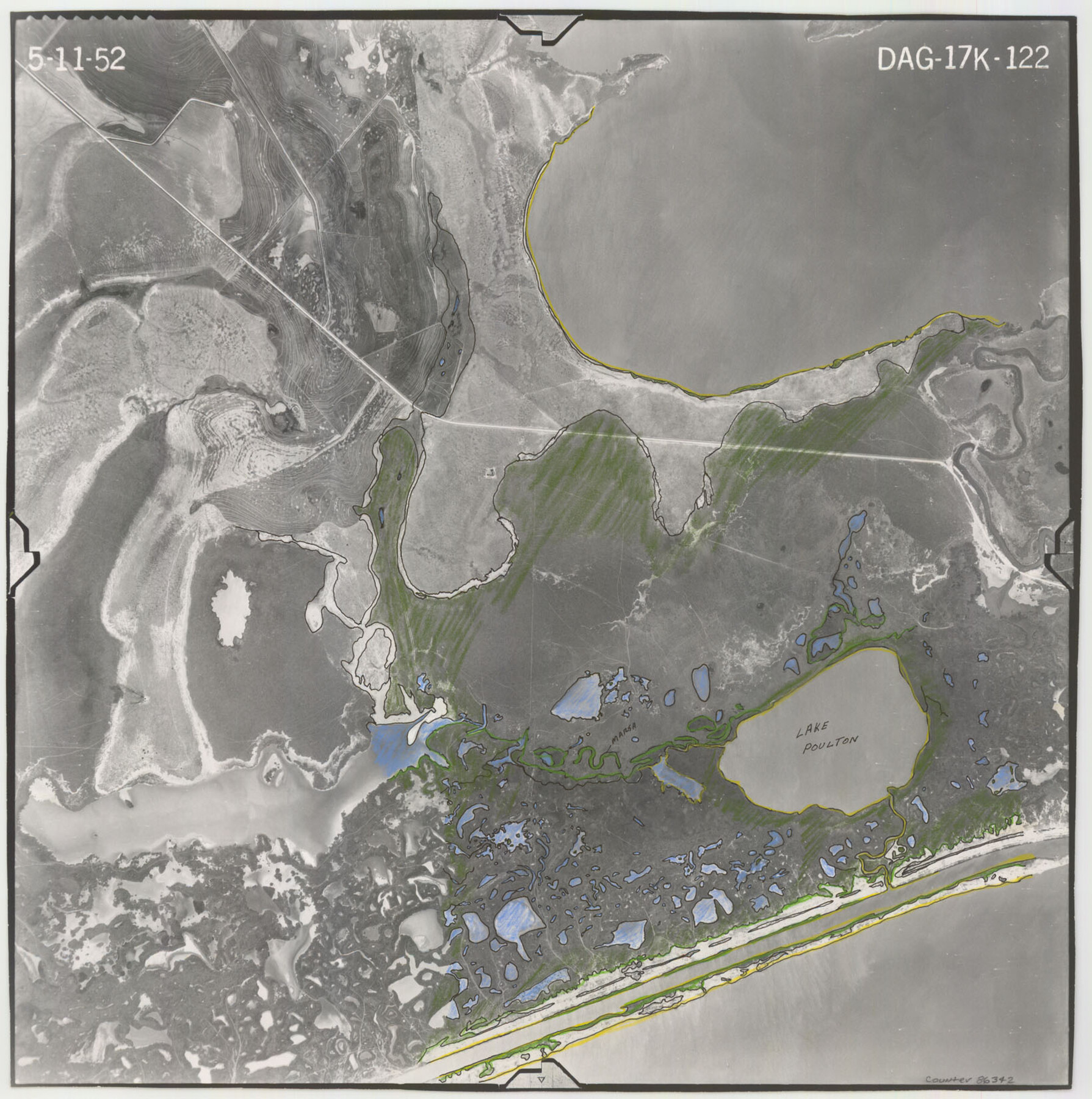
Flight Mission No. DAG-17K, Frame 122, Matagorda County
DAG-17K-122
-
Map/Doc
86342
-
Collection
General Map Collection
-
Object Dates
1952/5/11 (Creation Date)
-
People and Organizations
U. S. Department of Agriculture (Publisher)
-
Counties
Matagorda
-
Subjects
Aerial Photograph
-
Height x Width
16.5 x 16.4 inches
41.9 x 41.7 cm
-
Comments
Flown by Aero Exploration Company of Tulsa, Oklahoma.
Part of: General Map Collection
Map of Hardin County

Print $20.00
- Digital $50.00
Map of Hardin County
1902
Size 43.8 x 42.3 inches
Map/Doc 4699
Right-of-Way and Track Map, Texas State Railroad operated by the T. and N. O. R.R. Co.

Print $40.00
- Digital $50.00
Right-of-Way and Track Map, Texas State Railroad operated by the T. and N. O. R.R. Co.
1917
Size 24.3 x 55.7 inches
Map/Doc 64176
Runnels County Sketch File 27

Print $6.00
Runnels County Sketch File 27
1949
Size 11.5 x 8.9 inches
Map/Doc 35490
[Surveys in Chambers County]
![249, [Surveys in Chambers County], General Map Collection](https://historictexasmaps.com/wmedia_w700/maps/249.tif.jpg)
Print $2.00
- Digital $50.00
[Surveys in Chambers County]
1847
Size 7.8 x 5.0 inches
Map/Doc 249
Tanglewood, Station Map-Tracks & Structures-Lands, San Antonio & Aransas Pass Railway Co., Station 4804+179 to Station 4856+179

Print $4.00
- Digital $50.00
Tanglewood, Station Map-Tracks & Structures-Lands, San Antonio & Aransas Pass Railway Co., Station 4804+179 to Station 4856+179
1919
Size 11.7 x 18.6 inches
Map/Doc 62569
Map of Panola County Texas

Print $20.00
- Digital $50.00
Map of Panola County Texas
1850
Size 25.6 x 35.9 inches
Map/Doc 78317
Flight Mission No. CLL-1N, Frame 184, Willacy County

Print $20.00
- Digital $50.00
Flight Mission No. CLL-1N, Frame 184, Willacy County
1954
Size 18.4 x 22.1 inches
Map/Doc 87054
Callahan County Working Sketch 1

Print $20.00
- Digital $50.00
Callahan County Working Sketch 1
1939
Size 30.6 x 32.6 inches
Map/Doc 67883
Hansford County Boundary File 2

Print $14.00
- Digital $50.00
Hansford County Boundary File 2
Size 9.3 x 4.9 inches
Map/Doc 54245
Liberty County Rolled Sketch JLW

Print $40.00
- Digital $50.00
Liberty County Rolled Sketch JLW
1935
Size 28.0 x 85.5 inches
Map/Doc 9665
Map of Freestone County

Print $20.00
- Digital $50.00
Map of Freestone County
1874
Size 21.8 x 24.5 inches
Map/Doc 3563
Flight Mission No. DQO-2K, Frame 151, Galveston County

Print $20.00
- Digital $50.00
Flight Mission No. DQO-2K, Frame 151, Galveston County
1952
Size 18.9 x 22.6 inches
Map/Doc 85048
You may also like
Runnels County Rolled Sketch 44

Print $40.00
- Digital $50.00
Runnels County Rolled Sketch 44
Size 43.0 x 53.9 inches
Map/Doc 9871
Coke County Rolled Sketch 17

Print $20.00
- Digital $50.00
Coke County Rolled Sketch 17
1953
Size 36.1 x 45.2 inches
Map/Doc 8631
Flight Mission No. DQO-2K, Frame 141, Galveston County

Print $20.00
- Digital $50.00
Flight Mission No. DQO-2K, Frame 141, Galveston County
1952
Size 18.9 x 22.5 inches
Map/Doc 85038
[I. & G. N. Block 1, Runnels County School Land, T. C. Ry. Co. Block Z and G. C. & S. F. RR. Co. Block C-4]
![91661, [I. & G. N. Block 1, Runnels County School Land, T. C. Ry. Co. Block Z and G. C. & S. F. RR. Co. Block C-4], Twichell Survey Records](https://historictexasmaps.com/wmedia_w700/maps/91661-1.tif.jpg)
Print $20.00
- Digital $50.00
[I. & G. N. Block 1, Runnels County School Land, T. C. Ry. Co. Block Z and G. C. & S. F. RR. Co. Block C-4]
Size 29.7 x 17.9 inches
Map/Doc 91661
Map of survey of a part of Padre and Mustang Islands made for the Office of the Attorney General of the State of Texas

Print $20.00
- Digital $50.00
Map of survey of a part of Padre and Mustang Islands made for the Office of the Attorney General of the State of Texas
1941
Size 40.8 x 39.5 inches
Map/Doc 2257
Flight Mission No. CRC-6R, Frame 36, Chambers County

Print $20.00
- Digital $50.00
Flight Mission No. CRC-6R, Frame 36, Chambers County
1956
Size 18.8 x 22.4 inches
Map/Doc 84969
Maverick County Working Sketch 3

Print $20.00
- Digital $50.00
Maverick County Working Sketch 3
1939
Size 34.4 x 24.8 inches
Map/Doc 70895
San Jacinto County Sketch File 12a

Print $20.00
San Jacinto County Sketch File 12a
Size 12.8 x 14.3 inches
Map/Doc 35722
Dimmit County Working Sketch 33

Print $40.00
- Digital $50.00
Dimmit County Working Sketch 33
1959
Size 27.0 x 53.8 inches
Map/Doc 68694
W. S. Mabry Land Corners and Connections, Potter County

Print $20.00
- Digital $50.00
W. S. Mabry Land Corners and Connections, Potter County
Size 22.4 x 17.4 inches
Map/Doc 91805
Jefferson County Rolled Sketch 11

Print $40.00
- Digital $50.00
Jefferson County Rolled Sketch 11
Size 35.4 x 49.8 inches
Map/Doc 9277