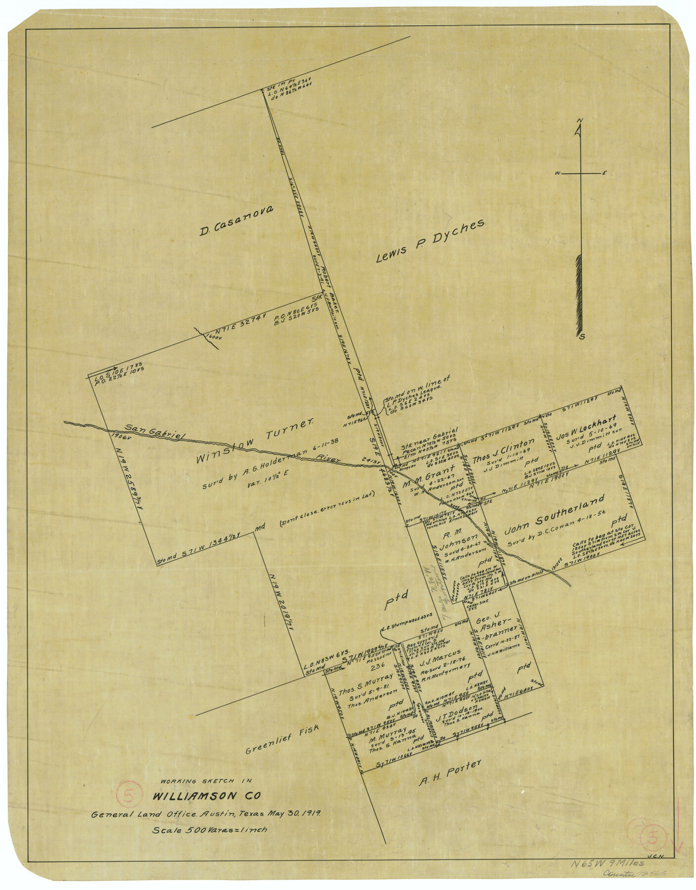
Williamson County Working Sketch 5
-
Map/Doc
72565
-
Collection
General Map Collection
-
Object Dates
5/30/1919 (Creation Date)
-
People and Organizations
John C. Newton (Draftsman)
-
Counties
Williamson
-
Subjects
Surveying Working Sketch
-
Height x Width
23.4 x 18.3 inches
59.4 x 46.5 cm
-
Scale
1" = 500 varas
Part of: General Map Collection
Topographical Map of the Rio Grande, Sheet No. 6

Print $20.00
- Digital $50.00
Topographical Map of the Rio Grande, Sheet No. 6
1912
Map/Doc 89530
Upton County Working Sketch 6

Print $20.00
- Digital $50.00
Upton County Working Sketch 6
1909
Size 17.1 x 27.0 inches
Map/Doc 69502
Coleman County Sketch File 46

Print $20.00
- Digital $50.00
Coleman County Sketch File 46
1894
Size 24.0 x 21.8 inches
Map/Doc 11125
Cherokee County Sketch File 36

Print $20.00
- Digital $50.00
Cherokee County Sketch File 36
1943
Size 23.0 x 22.2 inches
Map/Doc 11074
Matagorda County NRC Article 33.136 Sketch 2

Print $26.00
- Digital $50.00
Matagorda County NRC Article 33.136 Sketch 2
2005
Size 22.1 x 34.8 inches
Map/Doc 83395
Maps of Gulf Intracoastal Waterway, Texas - Sabine River to the Rio Grande and connecting waterways including ship channels

Print $20.00
- Digital $50.00
Maps of Gulf Intracoastal Waterway, Texas - Sabine River to the Rio Grande and connecting waterways including ship channels
1966
Size 14.6 x 20.5 inches
Map/Doc 61991
Dallas County Working Sketch 3

Print $20.00
- Digital $50.00
Dallas County Working Sketch 3
1922
Size 14.2 x 12.2 inches
Map/Doc 68569
Presidio County Working Sketch 62

Print $3.00
- Digital $50.00
Presidio County Working Sketch 62
1958
Size 12.6 x 9.5 inches
Map/Doc 71739
Map of Burnet Co.

Print $20.00
- Digital $50.00
Map of Burnet Co.
1887
Size 45.5 x 37.9 inches
Map/Doc 7816
Right of Way and Track Map, Houston & Texas Central R.R. operated by the T. and N. O. R.R., Fort Worth Branch

Print $40.00
- Digital $50.00
Right of Way and Track Map, Houston & Texas Central R.R. operated by the T. and N. O. R.R., Fort Worth Branch
1918
Size 30.9 x 56.9 inches
Map/Doc 64783
Shackelford County Sketch File 10

Print $20.00
- Digital $50.00
Shackelford County Sketch File 10
1918
Size 31.4 x 19.9 inches
Map/Doc 12316
Map of Zavalla County

Print $20.00
- Digital $50.00
Map of Zavalla County
1862
Size 24.2 x 20.5 inches
Map/Doc 4180
You may also like
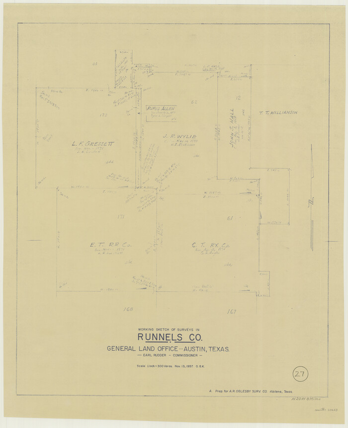
Runnels County Working Sketch 27
Print $20.00
- Digital $50.00
Runnels County Working Sketch 27
1957
Size 27.1 x 22.1 inches
Map/Doc 63623
Motley County Sketch File 31 (S)

Print $4.00
- Digital $50.00
Motley County Sketch File 31 (S)
1913
Size 14.4 x 6.7 inches
Map/Doc 32213
McMullen County Working Sketch 45

Print $20.00
- Digital $50.00
McMullen County Working Sketch 45
1981
Size 47.6 x 38.5 inches
Map/Doc 70746
[Blocks O, N, 34, B19, B29]
![92969, [Blocks O, N, 34, B19, B29], Twichell Survey Records](https://historictexasmaps.com/wmedia_w700/maps/92969-1.tif.jpg)
Print $20.00
- Digital $50.00
[Blocks O, N, 34, B19, B29]
Size 24.1 x 24.4 inches
Map/Doc 92969
Hamilton County Working Sketch 18

Print $20.00
- Digital $50.00
Hamilton County Working Sketch 18
1952
Size 22.4 x 25.1 inches
Map/Doc 63356
Travis County Sketch File 55

Print $20.00
- Digital $50.00
Travis County Sketch File 55
1945
Size 27.3 x 14.5 inches
Map/Doc 12471
Dimmit County Rolled Sketch 23

Print $20.00
- Digital $50.00
Dimmit County Rolled Sketch 23
2015
Size 18.1 x 24.3 inches
Map/Doc 93792
Plat of the Resubdivision of the Abandoned Townsite of Eschiti, Oklahoma

Print $4.00
- Digital $50.00
Plat of the Resubdivision of the Abandoned Townsite of Eschiti, Oklahoma
1907
Size 18.1 x 24.3 inches
Map/Doc 75150
Mills County Rolled Sketch 3

Print $20.00
- Digital $50.00
Mills County Rolled Sketch 3
1998
Size 26.4 x 37.9 inches
Map/Doc 6781
Crane County Sketch File 16

Print $20.00
- Digital $50.00
Crane County Sketch File 16
Size 15.8 x 19.1 inches
Map/Doc 11209
[Blocks 44, 6T, 26, B10, and B12]
![91528, [Blocks 44, 6T, 26, B10, and B12], Twichell Survey Records](https://historictexasmaps.com/wmedia_w700/maps/91528-1.tif.jpg)
Print $20.00
- Digital $50.00
[Blocks 44, 6T, 26, B10, and B12]
Size 19.7 x 15.8 inches
Map/Doc 91528
