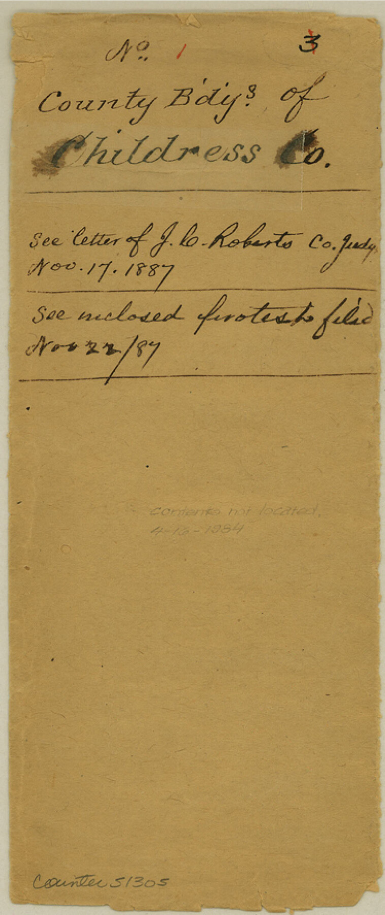
Childress County Boundary File 1
-
Map/Doc
51305
-
Collection
General Map Collection
-
Counties
Childress
-
Subjects
County Boundaries
-
Height x Width
8.9 x 3.8 inches
22.6 x 9.7 cm
Part of: General Map Collection
Old Miscellaneous File 4

Print $22.00
- Digital $50.00
Old Miscellaneous File 4
1845
Size 16.5 x 20.8 inches
Map/Doc 75416
Culberson County Working Sketch 36

Print $20.00
- Digital $50.00
Culberson County Working Sketch 36
1964
Size 20.8 x 24.4 inches
Map/Doc 68489
San Jacinto County Sketch File 17

Print $40.00
San Jacinto County Sketch File 17
1934
Size 60.1 x 26.3 inches
Map/Doc 10598
Concho County Sketch File 6

Print $8.00
- Digital $50.00
Concho County Sketch File 6
1858
Size 13.3 x 8.3 inches
Map/Doc 19127
Burnet County Working Sketch 19

Print $20.00
- Digital $50.00
Burnet County Working Sketch 19
1982
Size 38.2 x 36.7 inches
Map/Doc 67862
Flight Mission No. DAG-21K, Frame 27, Matagorda County

Print $20.00
- Digital $50.00
Flight Mission No. DAG-21K, Frame 27, Matagorda County
1952
Size 18.4 x 22.3 inches
Map/Doc 86394
Sherman County Boundary File 3

Print $55.00
- Digital $50.00
Sherman County Boundary File 3
Size 9.2 x 8.6 inches
Map/Doc 58773
Tarrant County

Print $40.00
- Digital $50.00
Tarrant County
1942
Size 48.6 x 37.8 inches
Map/Doc 73298
Hardin County Sketch File 44

Print $6.00
- Digital $50.00
Hardin County Sketch File 44
Size 6.7 x 7.4 inches
Map/Doc 25192
Flight Mission No. DAG-17K, Frame 138, Matagorda County

Print $20.00
- Digital $50.00
Flight Mission No. DAG-17K, Frame 138, Matagorda County
1952
Size 18.5 x 22.2 inches
Map/Doc 86355
Bandera County Working Sketch 33

Print $20.00
- Digital $50.00
Bandera County Working Sketch 33
1961
Size 22.4 x 28.8 inches
Map/Doc 67629
Galveston County NRC Article 33.136 Sketch 34

Print $20.00
- Digital $50.00
Galveston County NRC Article 33.136 Sketch 34
2005
Size 24.5 x 18.5 inches
Map/Doc 83405
You may also like
Map of Bastrop County

Print $20.00
- Digital $50.00
Map of Bastrop County
1861
Size 26.3 x 29.0 inches
Map/Doc 3280
Palo Pinto County Sketch File 6

Print $40.00
- Digital $50.00
Palo Pinto County Sketch File 6
1875
Size 9.3 x 18.8 inches
Map/Doc 33396
Edwards County Working Sketch 48

Print $20.00
- Digital $50.00
Edwards County Working Sketch 48
1950
Size 46.3 x 38.2 inches
Map/Doc 68924
Edwards County Rolled Sketch 37

Print $20.00
- Digital $50.00
Edwards County Rolled Sketch 37
2018
Size 23.3 x 30.2 inches
Map/Doc 94459
[Office Sketch of Jesse McGee survey in Sabine and Newton Counties]
![543, [Office Sketch of Jesse McGee survey in Sabine and Newton Counties], Maddox Collection](https://historictexasmaps.com/wmedia_w700/maps/543.tif.jpg)
Print $20.00
- Digital $50.00
[Office Sketch of Jesse McGee survey in Sabine and Newton Counties]
1910
Size 13.4 x 15.1 inches
Map/Doc 543

Flight Mission No. DCL-6C, Frame 176, Kenedy County

Print $20.00
- Digital $50.00
Flight Mission No. DCL-6C, Frame 176, Kenedy County
1943
Size 18.6 x 22.2 inches
Map/Doc 85988
Burnet County Working Sketch 15

Print $20.00
- Digital $50.00
Burnet County Working Sketch 15
1979
Size 38.2 x 30.4 inches
Map/Doc 67858
Brazos County Sketch File 3

Print $6.00
- Digital $50.00
Brazos County Sketch File 3
1861
Size 11.1 x 8.0 inches
Map/Doc 15554
Runnels County Sketch File E

Print $6.00
Runnels County Sketch File E
1895
Size 12.7 x 8.3 inches
Map/Doc 35481
Flight Mission No. BRE-1P, Frame 113, Nueces County

Print $20.00
- Digital $50.00
Flight Mission No. BRE-1P, Frame 113, Nueces County
1956
Size 18.6 x 22.6 inches
Map/Doc 86679
[Surveys in the Liberty District]
![273, [Surveys in the Liberty District], General Map Collection](https://historictexasmaps.com/wmedia_w700/maps/273.tif.jpg)
Print $2.00
- Digital $50.00
[Surveys in the Liberty District]
1841
Size 7.0 x 10.7 inches
Map/Doc 273