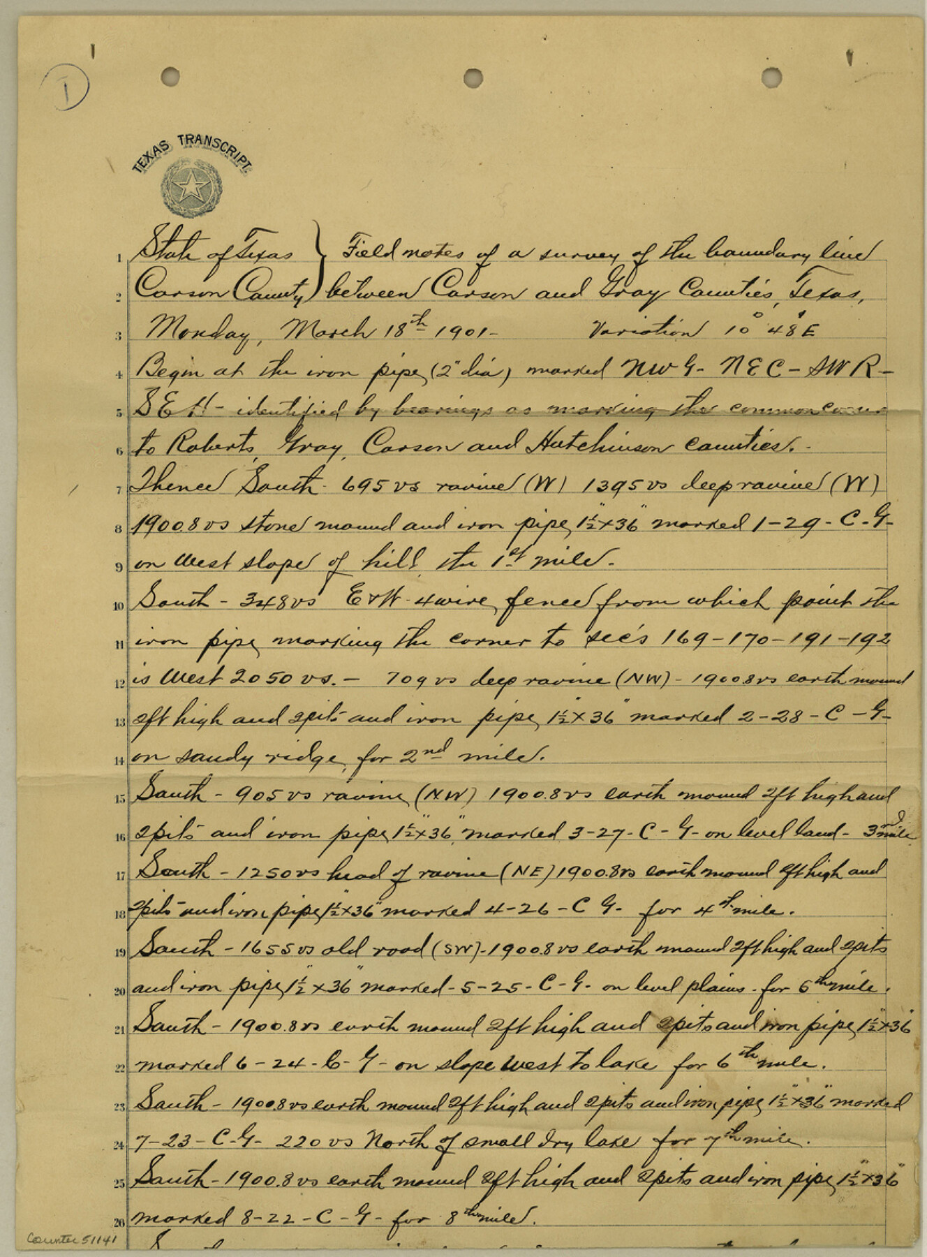
Carson County Boundary File 5b
Fieldnotes of the Bdy. line between Carson and Gray Counties
-
Map/Doc
51141
-
Collection
General Map Collection
-
Counties
Carson
-
Subjects
County Boundaries
-
Height x Width
11.7 x 8.6 inches
29.7 x 21.8 cm
Part of: General Map Collection
Panola County Working Sketch 35

Print $40.00
- Digital $50.00
Panola County Working Sketch 35
1983
Map/Doc 71444
Brewster County Rolled Sketch 72

Print $20.00
- Digital $50.00
Brewster County Rolled Sketch 72
1941
Size 42.0 x 28.4 inches
Map/Doc 5238
Hale County Sketch File 4

Print $20.00
- Digital $50.00
Hale County Sketch File 4
1891
Size 18.8 x 16.4 inches
Map/Doc 11594
Hudspeth County Rolled Sketch 51

Print $20.00
- Digital $50.00
Hudspeth County Rolled Sketch 51
1974
Size 19.2 x 25.7 inches
Map/Doc 6256
Field notes for subdivisions of University Leagues/Surveys in Fannin, Grayson, McLennan, Hunt, Lamar, Collin, and Cooke Counties

Field notes for subdivisions of University Leagues/Surveys in Fannin, Grayson, McLennan, Hunt, Lamar, Collin, and Cooke Counties
Map/Doc 81727
Flight Mission No. BRA-7M, Frame 74, Jefferson County

Print $20.00
- Digital $50.00
Flight Mission No. BRA-7M, Frame 74, Jefferson County
1953
Size 18.6 x 22.4 inches
Map/Doc 85496
Borden County Working Sketch 12

Print $20.00
- Digital $50.00
Borden County Working Sketch 12
1956
Size 43.1 x 37.0 inches
Map/Doc 67472
Flight Mission No. CGI-3N, Frame 123, Cameron County

Print $20.00
- Digital $50.00
Flight Mission No. CGI-3N, Frame 123, Cameron County
1954
Size 18.6 x 22.2 inches
Map/Doc 84596
Madison County

Print $20.00
- Digital $50.00
Madison County
1871
Size 15.2 x 20.3 inches
Map/Doc 4587
Webb County Rolled Sketch 38

Print $20.00
- Digital $50.00
Webb County Rolled Sketch 38
1940
Size 22.2 x 16.0 inches
Map/Doc 8193
[Surveys along the Colorado River]
![112, [Surveys along the Colorado River], General Map Collection](https://historictexasmaps.com/wmedia_w700/maps/112.tif.jpg)
Print $2.00
- Digital $50.00
[Surveys along the Colorado River]
1841
Size 12.2 x 8.3 inches
Map/Doc 112
Angelina County Sketch File 11b

Print $6.00
- Digital $50.00
Angelina County Sketch File 11b
1859
Size 17.7 x 8.3 inches
Map/Doc 12944
You may also like
Richland Hills Addition to Muleshoe, Bailey County, Texas

Print $20.00
- Digital $50.00
Richland Hills Addition to Muleshoe, Bailey County, Texas
1957
Size 22.7 x 31.7 inches
Map/Doc 92461
Castro County Sketch File 4m

Print $4.00
- Digital $50.00
Castro County Sketch File 4m
Size 13.6 x 8.6 inches
Map/Doc 17489
Grimes County Working Sketch 17

Print $20.00
- Digital $50.00
Grimes County Working Sketch 17
1996
Size 31.1 x 26.6 inches
Map/Doc 63308
Presidio County Rolled Sketch 139

Print $20.00
- Digital $50.00
Presidio County Rolled Sketch 139
2002
Size 24.5 x 27.5 inches
Map/Doc 78647
Travis County Boundary File 4

Print $52.00
- Digital $50.00
Travis County Boundary File 4
Size 9.5 x 8.2 inches
Map/Doc 59420
Map of the State of Texas published by the International and Gt. Northern Railroad

Print $20.00
- Digital $50.00
Map of the State of Texas published by the International and Gt. Northern Railroad
1881
Size 16.0 x 22.2 inches
Map/Doc 94092
[Surveys along the Leon River and Plum Creek]
![255, [Surveys along the Leon River and Plum Creek], General Map Collection](https://historictexasmaps.com/wmedia_w700/maps/255.tif.jpg)
Print $2.00
- Digital $50.00
[Surveys along the Leon River and Plum Creek]
1846
Size 11.7 x 7.6 inches
Map/Doc 255
Donley County Sketch File B3

Print $20.00
- Digital $50.00
Donley County Sketch File B3
1918
Size 22.0 x 15.0 inches
Map/Doc 11373
Wheeler County Boundary File 1b

Print $2.00
- Digital $50.00
Wheeler County Boundary File 1b
Size 12.3 x 8.8 inches
Map/Doc 59869

[Blocks M-21, Z, and E. L. & RR. Block L]
![91151, [Blocks M-21, Z, and E. L. & RR. Block L], Twichell Survey Records](https://historictexasmaps.com/wmedia_w700/maps/91151-1.tif.jpg)
Print $20.00
- Digital $50.00
[Blocks M-21, Z, and E. L. & RR. Block L]
Size 14.5 x 17.9 inches
Map/Doc 91151
Crockett County Working Sketch 43

Print $20.00
- Digital $50.00
Crockett County Working Sketch 43
1931
Size 26.1 x 21.7 inches
Map/Doc 68376