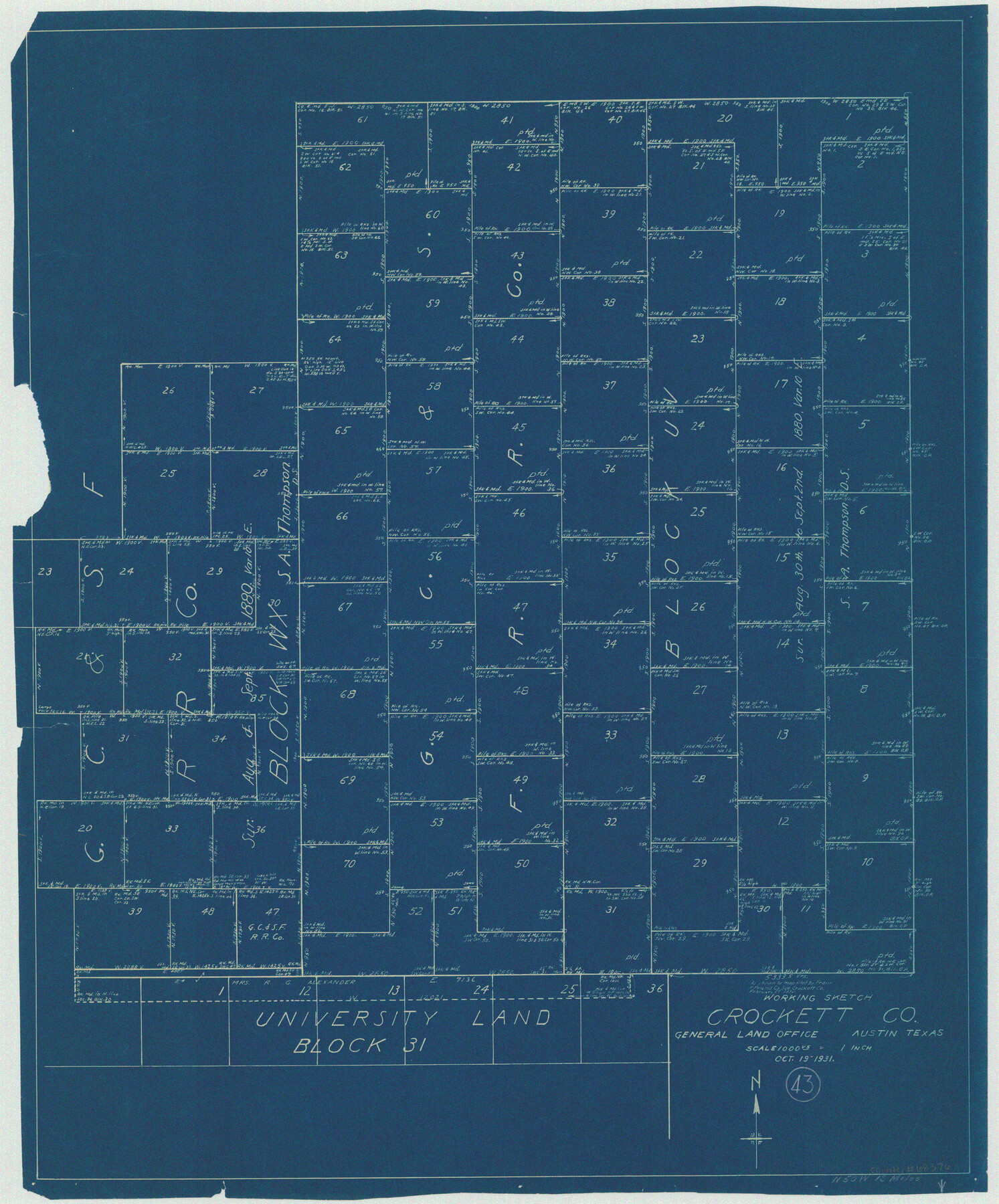
Crockett County Working Sketch 43
-
Map/Doc
68376
-
Collection
General Map Collection
-
Object Dates
10/19/1931 (Creation Date)
-
Counties
Crockett
-
Subjects
Surveying Working Sketch
-
Height x Width
26.1 x 21.7 inches
66.3 x 55.1 cm
-
Scale
1" = 1000 varas
Part of: General Map Collection
Chambers County Sketch File 35

Print $14.00
- Digital $50.00
Chambers County Sketch File 35
Size 7.1 x 7.6 inches
Map/Doc 17625
Aransas County Sketch File 21

Print $2.00
- Digital $50.00
Aransas County Sketch File 21
Size 8.0 x 8.9 inches
Map/Doc 13157
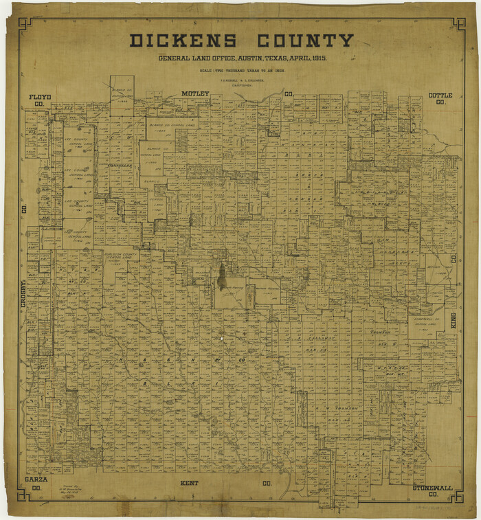
Dickens County
Print $20.00
- Digital $50.00
Dickens County
1915
Size 42.2 x 39.0 inches
Map/Doc 66805
Hardin County Sketch File 34

Print $6.00
- Digital $50.00
Hardin County Sketch File 34
Size 12.9 x 8.5 inches
Map/Doc 25172
Jack County Sketch File 15

Print $4.00
- Digital $50.00
Jack County Sketch File 15
1880
Size 7.3 x 13.7 inches
Map/Doc 27545
Ward County Working Sketch 27

Print $40.00
- Digital $50.00
Ward County Working Sketch 27
1964
Size 52.7 x 27.3 inches
Map/Doc 72333
Flight Mission No. BQR-9K, Frame 44, Brazoria County

Print $20.00
- Digital $50.00
Flight Mission No. BQR-9K, Frame 44, Brazoria County
1952
Size 18.7 x 22.3 inches
Map/Doc 84048
Zapata County Rolled Sketch 20

Print $40.00
- Digital $50.00
Zapata County Rolled Sketch 20
1956
Size 21.2 x 49.1 inches
Map/Doc 10171
Swisher County

Print $20.00
- Digital $50.00
Swisher County
1941
Size 44.7 x 38.5 inches
Map/Doc 95648
Kendall County Boundary File 2

Print $4.00
- Digital $50.00
Kendall County Boundary File 2
Size 10.2 x 8.2 inches
Map/Doc 55746

Jones County Working Sketch 4

Print $20.00
- Digital $50.00
Jones County Working Sketch 4
1946
Size 35.5 x 20.6 inches
Map/Doc 66642
You may also like
Grimes County Rolled Sketch 1

Print $20.00
- Digital $50.00
Grimes County Rolled Sketch 1
1945
Size 34.6 x 35.0 inches
Map/Doc 9007
[Lynn County School Land Leagues 292, 293, PSL Block C-30, and D. W. RR. Co. Block H]
![90797, [Lynn County School Land Leagues 292, 293, PSL Block C-30, and D. W. RR. Co. Block H], Twichell Survey Records](https://historictexasmaps.com/wmedia_w700/maps/90797-1.tif.jpg)
Print $20.00
- Digital $50.00
[Lynn County School Land Leagues 292, 293, PSL Block C-30, and D. W. RR. Co. Block H]
Size 21.3 x 20.6 inches
Map/Doc 90797
Travels to the source of the Missouri River and across the American Continent to the Pacific Ocean - Vol. 1

Travels to the source of the Missouri River and across the American Continent to the Pacific Ocean - Vol. 1
1815
Map/Doc 97411
Pecos County Rolled Sketch 176

Print $20.00
- Digital $50.00
Pecos County Rolled Sketch 176
1978
Size 14.1 x 33.6 inches
Map/Doc 7296
General Highway Map, Calhoun County, Texas

Print $20.00
General Highway Map, Calhoun County, Texas
1961
Size 18.3 x 24.4 inches
Map/Doc 79395
[Plat Showing Colorado, Upshur & Travis County School Land and Surrounding Area in Baylor & Throckmorton Counties, Texas]
![75790, [Plat Showing Colorado, Upshur & Travis County School Land and Surrounding Area in Baylor & Throckmorton Counties, Texas], Maddox Collection](https://historictexasmaps.com/wmedia_w700/maps/75790.tif.jpg)
Print $20.00
- Digital $50.00
[Plat Showing Colorado, Upshur & Travis County School Land and Surrounding Area in Baylor & Throckmorton Counties, Texas]
1889
Size 15.8 x 20.5 inches
Map/Doc 75790
Menard County Rolled Sketch 2

Print $20.00
- Digital $50.00
Menard County Rolled Sketch 2
1883
Size 25.0 x 19.9 inches
Map/Doc 6752
Reagan County Working Sketch 25

Print $20.00
- Digital $50.00
Reagan County Working Sketch 25
1958
Size 45.8 x 42.8 inches
Map/Doc 71867
Atascosa County Rolled Sketch 7

Print $20.00
- Digital $50.00
Atascosa County Rolled Sketch 7
1913
Size 26.1 x 26.7 inches
Map/Doc 5092
Hamilton County Boundary File 2

Print $4.00
- Digital $50.00
Hamilton County Boundary File 2
Size 14.2 x 8.8 inches
Map/Doc 54195
Martin County Boundary File 62a

Print $30.00
- Digital $50.00
Martin County Boundary File 62a
Size 12.8 x 8.3 inches
Map/Doc 56801
Haskell County Working Sketch 17

Print $20.00
- Digital $50.00
Haskell County Working Sketch 17
2011
Size 34.3 x 32.3 inches
Map/Doc 89989