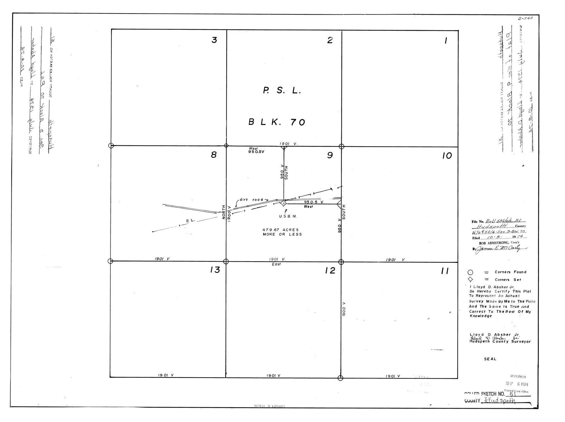
Hudspeth County Rolled Sketch 51
[Plat of section 9, Block 70]
- 
                          Map/Doc
6256
 - 
                            Collection
General Map Collection
 - 
                            Object Dates
1974 (Creation Date)
1974/10/8 (File Date)
 - 
                            People and Organizations
Lloyd D. Absher, Jr. (Surveyor/Engineer)
 - 
                            Counties
Hudspeth
 - 
                            Subjects
Surveying Rolled Sketch
 - 
                            Height x Width
19.2 x 25.7 inches
48.8 x 65.3 cm
 
Part of: General Map Collection
            Map of the Western Part of Bexar District


                                            Print $40.00                    
                                             -                         Digital $50.00                                    
                Map of the Western Part of Bexar District
1849
Size 64.0 x 54.3 inches
                                Map/Doc 16944
            
            Garza County Rolled Sketch 16


                                            Print $20.00                    
                                             -                         Digital $50.00                                    
                Garza County Rolled Sketch 16
Size 30.5 x 32.3 inches
                                Map/Doc 9048
            
            Map of France, Spain, Portugal and Italy engraved to illustrate Mitchell's school and family geography (Inset: Greece and the Ionian Islands)


                                            Print $20.00                    
                                             -                         Digital $50.00                                    
                Map of France, Spain, Portugal and Italy engraved to illustrate Mitchell's school and family geography (Inset: Greece and the Ionian Islands)
1846
Size 9.5 x 11.8 inches
                                Map/Doc 93505
            
            Pecos County Working Sketch Graphic Index - south part


                                            Print $20.00                    
                                             -                         Digital $50.00                                    
                Pecos County Working Sketch Graphic Index - south part
1976
Size 35.3 x 43.2 inches
                                Map/Doc 76665
            
            Kinney County Sketch File 21


                                            Print $50.00                    
                                             -                         Digital $50.00                                    
                Kinney County Sketch File 21
1887
Size 14.4 x 8.8 inches
                                Map/Doc 29135
            
            Texas Gulf Coast Map from the Sabine River to the Rio Grande as subdivided for mineral development


                                            Print $40.00                    
                                             -                         Digital $50.00                                    
                Texas Gulf Coast Map from the Sabine River to the Rio Grande as subdivided for mineral development
1948
Size 60.9 x 36.7 inches
                                Map/Doc 2909
            
            Sterling County Rolled Sketch 11


                                            Print $20.00                    
                                             -                         Digital $50.00                                    
                Sterling County Rolled Sketch 11
1884
Size 22.5 x 46.6 inches
                                Map/Doc 9945
            
            Pecos County Sketch File 28a


                                            Print $20.00                    
                                             -                         Digital $50.00                                    
                Pecos County Sketch File 28a
Size 24.3 x 26.6 inches
                                Map/Doc 12169
            
            Motley County Sketch File 13 (N)


                                            Print $10.00                    
                                             -                         Digital $50.00                                    
                Motley County Sketch File 13 (N)
1911
Size 11.1 x 8.6 inches
                                Map/Doc 32043
            
            Loving County Working Sketch 21


                                            Print $20.00                    
                                             -                         Digital $50.00                                    
                Loving County Working Sketch 21
1984
Size 26.7 x 36.0 inches
                                Map/Doc 70655
            
            Sabine River, Watershed of the Sabine and Neches Rivers


                                            Print $20.00                    
                                             -                         Digital $50.00                                    
                Sabine River, Watershed of the Sabine and Neches Rivers
Size 39.5 x 36.0 inches
                                Map/Doc 65132
            
            El Paso County Boundary File 7


                                            Print $14.00                    
                                             -                         Digital $50.00                                    
                El Paso County Boundary File 7
Size 14.0 x 8.8 inches
                                Map/Doc 53087
            You may also like
            Trinity County Working Sketch 18


                                            Print $20.00                    
                                             -                         Digital $50.00                                    
                Trinity County Working Sketch 18
1982
Size 13.4 x 11.1 inches
                                Map/Doc 69467
            
            Kaufman County, Texas


                                            Print $20.00                    
                                             -                         Digital $50.00                                    
                Kaufman County, Texas
1871
Size 24.9 x 18.8 inches
                                Map/Doc 735
            
            Flight Mission No. DQO-2K, Frame 97, Galveston County


                                            Print $20.00                    
                                             -                         Digital $50.00                                    
                Flight Mission No. DQO-2K, Frame 97, Galveston County
1952
Size 18.7 x 22.5 inches
                                Map/Doc 85024
            
            General Highway Map, McCulloch County, Texas


                                            Print $20.00                    
                                    
                General Highway Map, McCulloch County, Texas
1940
Size 24.6 x 18.2 inches
                                Map/Doc 79190
            
            Dallas County Sketch File 24


                                            Print $4.00                    
                                             -                         Digital $50.00                                    
                Dallas County Sketch File 24
1860
Size 14.9 x 8.4 inches
                                Map/Doc 20459
            
            Flight Mission No. BRE-1P, Frame 54, Nueces County


                                            Print $20.00                    
                                             -                         Digital $50.00                                    
                Flight Mission No. BRE-1P, Frame 54, Nueces County
1956
Size 18.4 x 22.2 inches
                                Map/Doc 86643
            
            Wood County Sketch File 15


                                            Print $5.00                    
                                             -                         Digital $50.00                                    
                Wood County Sketch File 15
1835
Size 11.0 x 16.3 inches
                                Map/Doc 40694
            
            Cottle County Sketch File 11


                                            Print $40.00                    
                                             -                         Digital $50.00                                    
                Cottle County Sketch File 11
Size 12.9 x 13.3 inches
                                Map/Doc 19489
            
            Andrews County Rolled Sketch 29


                                            Print $20.00                    
                                             -                         Digital $50.00                                    
                Andrews County Rolled Sketch 29
1949
Size 36.6 x 16.3 inches
                                Map/Doc 77173
            
            Laguna Madre, Texas from Triangulation Station Singer to Latitude 26° 20'


                                            Print $40.00                    
                                             -                         Digital $50.00                                    
                Laguna Madre, Texas from Triangulation Station Singer to Latitude 26° 20'
1880
Size 31.9 x 53.4 inches
                                Map/Doc 73493
            
            Map of a Part of Lea County, New Mexico


                                            Print $40.00                    
                                             -                         Digital $50.00                                    
                Map of a Part of Lea County, New Mexico
Size 60.5 x 42.0 inches
                                Map/Doc 89910
            
            Flight Mission No. BRA-7M, Frame 128, Jefferson County


                                            Print $20.00                    
                                             -                         Digital $50.00                                    
                Flight Mission No. BRA-7M, Frame 128, Jefferson County
1953
Size 18.8 x 22.5 inches
                                Map/Doc 85522