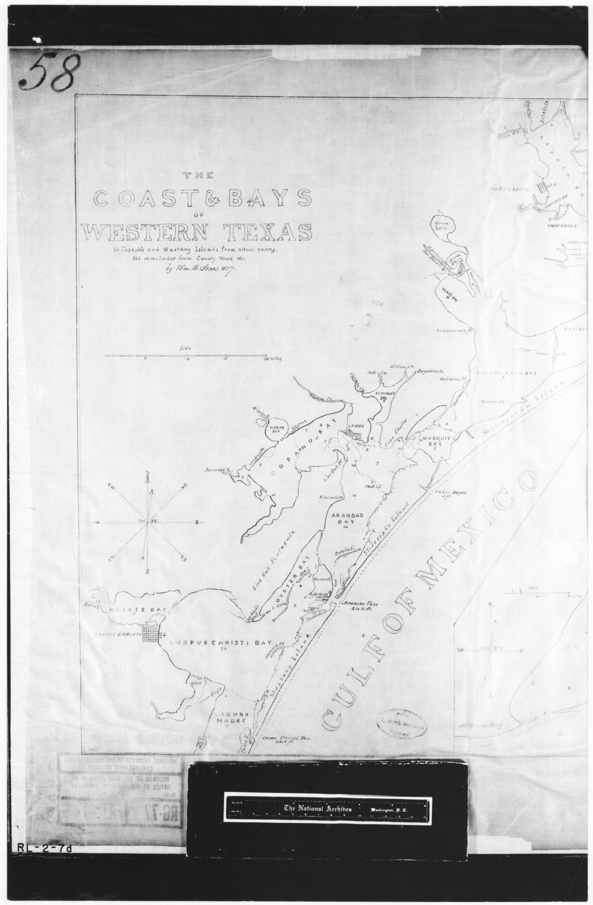
The Coast & Bays of Western Texas, St. Joseph's and Mustang Islands from actual survey, the remainder from county maps, etc.
RL-2-7d
-
Map/Doc
72766
-
Collection
General Map Collection
-
Object Dates
1857 (Creation Date)
-
People and Organizations
William H. Jones (Author)
-
Subjects
Gulf of Mexico
-
Height x Width
27.9 x 18.3 inches
70.9 x 46.5 cm
-
Comments
B/W photostat copy from National Archives in multiple pieces.
Part of: General Map Collection
Nueces County Sketch File 75

Print $20.00
- Digital $50.00
Nueces County Sketch File 75
1977
Size 26.1 x 27.8 inches
Map/Doc 42199
Foard County Sketch File 8

Print $6.00
- Digital $50.00
Foard County Sketch File 8
Size 10.5 x 11.8 inches
Map/Doc 22810
Brazoria County Sketch File 15b

Print $40.00
- Digital $50.00
Brazoria County Sketch File 15b
Size 13.2 x 26.3 inches
Map/Doc 10951
Cooke County Working Sketch 29
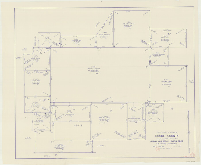
Print $20.00
- Digital $50.00
Cooke County Working Sketch 29
1977
Size 28.7 x 35.0 inches
Map/Doc 68266
Gregg County Rolled Sketch 8

Print $40.00
- Digital $50.00
Gregg County Rolled Sketch 8
1933
Size 26.3 x 50.9 inches
Map/Doc 9027
Topographical Map of the Rio Grande, Sheet No. 30

Print $20.00
- Digital $50.00
Topographical Map of the Rio Grande, Sheet No. 30
1912
Map/Doc 89554
The Town of Charlotte Situated on the San Antonio, Uvalde and Gulf Railway in Atascosa County, Texas

Print $20.00
- Digital $50.00
The Town of Charlotte Situated on the San Antonio, Uvalde and Gulf Railway in Atascosa County, Texas
1911
Size 29.7 x 24.5 inches
Map/Doc 4823

Flight Mission No. BRA-8M, Frame 135, Jefferson County

Print $20.00
- Digital $50.00
Flight Mission No. BRA-8M, Frame 135, Jefferson County
1953
Size 18.7 x 22.3 inches
Map/Doc 85631
El Paso County

Print $40.00
- Digital $50.00
El Paso County
1881
Size 52.0 x 36.8 inches
Map/Doc 89059
Bowie County Sketch File 3

Print $40.00
- Digital $50.00
Bowie County Sketch File 3
Size 25.7 x 38.1 inches
Map/Doc 10941
Map of Webb Co.

Print $20.00
- Digital $50.00
Map of Webb Co.
1901
Size 40.4 x 47.1 inches
Map/Doc 16919
You may also like
Flight Mission No. DQN-6K, Frame 71, Calhoun County

Print $20.00
- Digital $50.00
Flight Mission No. DQN-6K, Frame 71, Calhoun County
1953
Size 18.5 x 22.2 inches
Map/Doc 84443
[Sketch of surveys in Hutchinson County]
![75817, [Sketch of surveys in Hutchinson County], Maddox Collection](https://historictexasmaps.com/wmedia_w700/maps/75817.tif.jpg)
Print $20.00
- Digital $50.00
[Sketch of surveys in Hutchinson County]
1912
Size 25.0 x 26.8 inches
Map/Doc 75817
[Maps of surveys in Reeves & Culberson Cos]
![61142, [Maps of surveys in Reeves & Culberson Cos], General Map Collection](https://historictexasmaps.com/wmedia_w700/maps/61142.tif.jpg)
Print $20.00
- Digital $50.00
[Maps of surveys in Reeves & Culberson Cos]
1937
Size 30.6 x 24.8 inches
Map/Doc 61142
Rusk County Sketch File 45

Print $8.00
Rusk County Sketch File 45
1959
Size 11.3 x 8.8 inches
Map/Doc 35591
[J. Poitevent Block 2, T. T. RR. Block 2, C. C. Slaughter Block 1]
![90624, [J. Poitevent Block 2, T. T. RR. Block 2, C. C. Slaughter Block 1], Twichell Survey Records](https://historictexasmaps.com/wmedia_w700/maps/90624-1.tif.jpg)
Print $2.00
- Digital $50.00
[J. Poitevent Block 2, T. T. RR. Block 2, C. C. Slaughter Block 1]
Size 8.5 x 11.6 inches
Map/Doc 90624
Kimble County Working Sketch 6

Print $20.00
- Digital $50.00
Kimble County Working Sketch 6
1915
Size 24.4 x 26.5 inches
Map/Doc 70074
Ward County Working Sketch 25

Print $40.00
- Digital $50.00
Ward County Working Sketch 25
1957
Size 74.3 x 25.6 inches
Map/Doc 72331
La Salle County Working Sketch 19

Print $20.00
- Digital $50.00
La Salle County Working Sketch 19
1941
Size 24.6 x 31.4 inches
Map/Doc 70320
Dickens County Sketch File 22

Print $8.00
- Digital $50.00
Dickens County Sketch File 22
1913
Size 11.2 x 9.1 inches
Map/Doc 20985
Wilbarger County Aerial Photograph Index Sheet 2

Print $20.00
- Digital $50.00
Wilbarger County Aerial Photograph Index Sheet 2
1950
Size 22.4 x 17.5 inches
Map/Doc 83751
Wilson County

Print $40.00
- Digital $50.00
Wilson County
1921
Size 39.6 x 48.5 inches
Map/Doc 73327
Jeff Davis County Boundary File 1a

Print $8.00
- Digital $50.00
Jeff Davis County Boundary File 1a
Size 14.3 x 8.8 inches
Map/Doc 55501