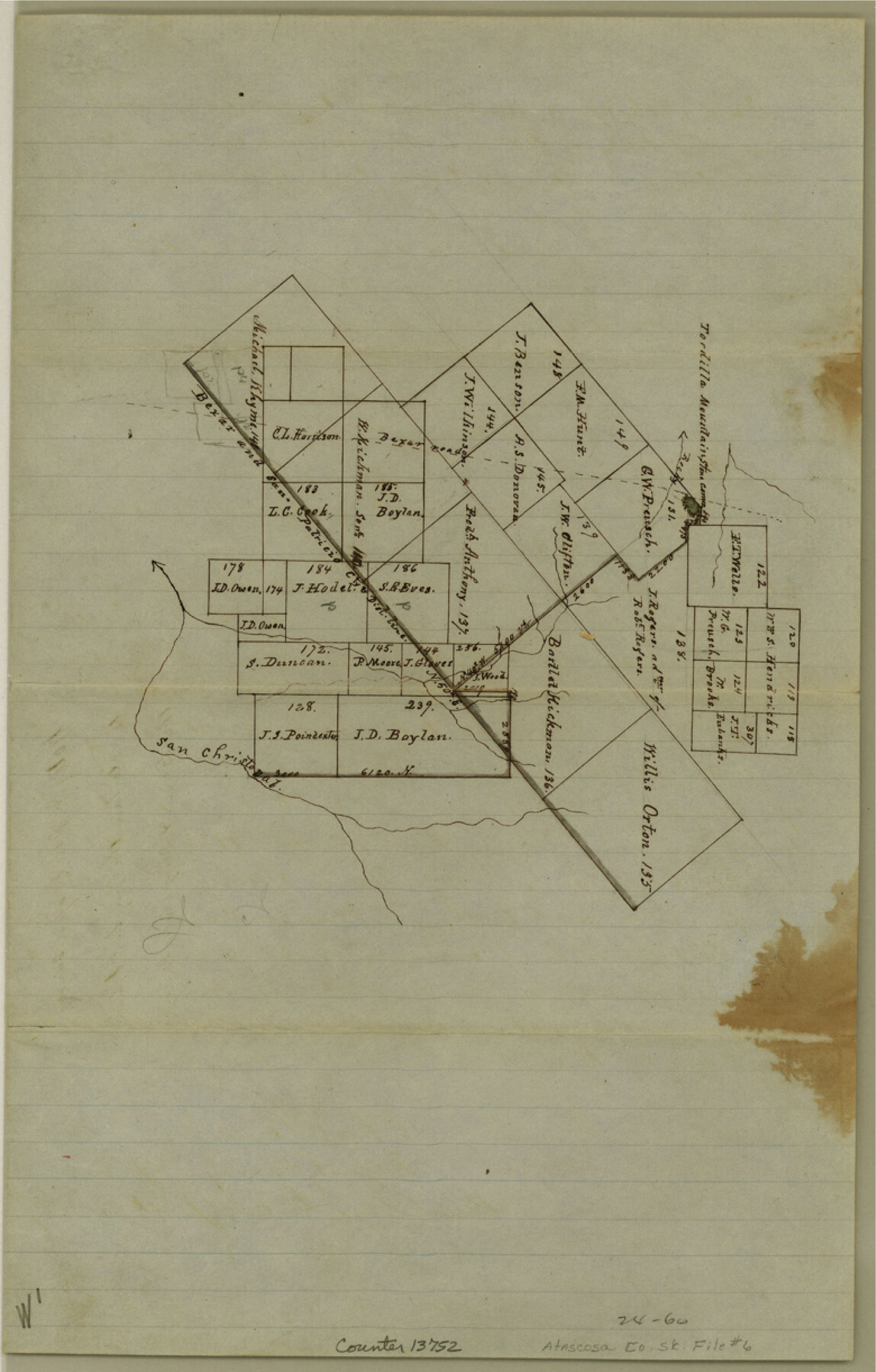
Atascosa County Sketch File 6
[Field notes and plat of a survey made to ascertain what conflict there is between the surveys in the southeast corner of the county near San Christoval Creek]
-
Map/Doc
13752
-
Collection
General Map Collection
-
Object Dates
1855/3/9 (File Date)
-
People and Organizations
Charles A. Russell (Surveyor/Engineer)
-
Counties
Atascosa Karnes Live Oak
-
Subjects
Surveying Sketch File
-
Height x Width
12.2 x 7.8 inches
31.0 x 19.8 cm
-
Medium
paper, manuscript
-
Features
Tordilla Mountains
Bexar Road
San Christoval Creek
Part of: General Map Collection
Flight Mission No. CRC-2R, Frame 62, Chambers County

Print $20.00
- Digital $50.00
Flight Mission No. CRC-2R, Frame 62, Chambers County
1956
Size 18.6 x 22.5 inches
Map/Doc 84733
Greer County Sketch File 2

Print $20.00
- Digital $50.00
Greer County Sketch File 2
1883
Size 25.4 x 19.9 inches
Map/Doc 11582
Map of Chicago, Rock Island & Texas Railway through Montague and Wise Counties, Texas

Print $40.00
- Digital $50.00
Map of Chicago, Rock Island & Texas Railway through Montague and Wise Counties, Texas
1893
Size 20.2 x 124.5 inches
Map/Doc 64468
Brewster County Working Sketch 33

Print $20.00
- Digital $50.00
Brewster County Working Sketch 33
1943
Size 32.5 x 38.2 inches
Map/Doc 67567
Harris County Sketch File 69a

Print $20.00
- Digital $50.00
Harris County Sketch File 69a
1938
Size 19.4 x 21.3 inches
Map/Doc 11663
Township 8 South Range 13 West, South Western District, Louisiana

Print $20.00
- Digital $50.00
Township 8 South Range 13 West, South Western District, Louisiana
1879
Size 19.5 x 24.8 inches
Map/Doc 65888
Dallas County Sketch File 25

Print $20.00
- Digital $50.00
Dallas County Sketch File 25
Size 14.9 x 14.6 inches
Map/Doc 11288
Uvalde County Sketch File 21

Print $8.00
- Digital $50.00
Uvalde County Sketch File 21
1882
Size 14.2 x 8.8 inches
Map/Doc 39004
[Cherokee Reserve, West Boundary Line, plat and field notes]
![2000, [Cherokee Reserve, West Boundary Line, plat and field notes], General Map Collection](https://historictexasmaps.com/wmedia_w700/pdf_converted_jpg/qi_pdf_thumbnail_931.jpg)
Print $54.00
[Cherokee Reserve, West Boundary Line, plat and field notes]
1841
Size 9.4 x 14.7 inches
Map/Doc 2000
Belton and Stillhouse Hollow Reservoirs (Verso)

Belton and Stillhouse Hollow Reservoirs (Verso)
1972
Size 29.3 x 22.7 inches
Map/Doc 94173
Flight Mission No. DQN-2K, Frame 196, Calhoun County

Print $20.00
- Digital $50.00
Flight Mission No. DQN-2K, Frame 196, Calhoun County
1953
Size 16.3 x 16.1 inches
Map/Doc 84335
Parker County Working Sketch 4

Print $20.00
- Digital $50.00
Parker County Working Sketch 4
1941
Map/Doc 71454
You may also like
Pecos County Rolled Sketch 39

Print $20.00
- Digital $50.00
Pecos County Rolled Sketch 39
1908
Size 21.8 x 33.2 inches
Map/Doc 7217
Irion County Sketch File 1

Print $20.00
- Digital $50.00
Irion County Sketch File 1
1881
Size 43.9 x 18.3 inches
Map/Doc 10615
St. Louis Southwestern Railway of Texas

Print $20.00
- Digital $50.00
St. Louis Southwestern Railway of Texas
1906
Size 21.2 x 30.0 inches
Map/Doc 64447
Sabine County Working Sketch 4

Print $20.00
- Digital $50.00
Sabine County Working Sketch 4
1913
Size 23.7 x 32.0 inches
Map/Doc 63675
Travis County Sketch File 18

Print $20.00
- Digital $50.00
Travis County Sketch File 18
1872
Size 24.2 x 25.4 inches
Map/Doc 12458
San Patricio County NRC Article 33.136 Location Key Sheet

Print $20.00
- Digital $50.00
San Patricio County NRC Article 33.136 Location Key Sheet
1975
Size 27.0 x 23.0 inches
Map/Doc 77037
Intracoastal Waterway in Texas - Corpus Christi to Point Isabel including Arroyo Colorado to Mo. Pac. R.R. Bridge Near Harlingen

Print $20.00
- Digital $50.00
Intracoastal Waterway in Texas - Corpus Christi to Point Isabel including Arroyo Colorado to Mo. Pac. R.R. Bridge Near Harlingen
1934
Size 21.8 x 32.7 inches
Map/Doc 61885
Carson County Working Sketch 3

Print $20.00
- Digital $50.00
Carson County Working Sketch 3
1922
Size 18.3 x 26.3 inches
Map/Doc 67874
[Surveys along the Pedernales River and Cypress Creek]
![121, [Surveys along the Pedernales River and Cypress Creek], General Map Collection](https://historictexasmaps.com/wmedia_w700/maps/121.tif.jpg)
Print $2.00
- Digital $50.00
[Surveys along the Pedernales River and Cypress Creek]
1841
Size 8.3 x 7.7 inches
Map/Doc 121
Rains County Rolled Sketch 1

Print $40.00
- Digital $50.00
Rains County Rolled Sketch 1
1958
Size 42.0 x 65.2 inches
Map/Doc 9806
[Surveys in the Bexar District along the Guadalupe River]
![124, [Surveys in the Bexar District along the Guadalupe River], General Map Collection](https://historictexasmaps.com/wmedia_w700/maps/124.tif.jpg)
Print $3.00
- Digital $50.00
[Surveys in the Bexar District along the Guadalupe River]
1841
Size 17.2 x 10.8 inches
Map/Doc 124
Map of Fisher & Miller's Colony made from the records in the office of the District Surveyor of Bexar comprising also all the recent surveys

Print $20.00
- Digital $50.00
Map of Fisher & Miller's Colony made from the records in the office of the District Surveyor of Bexar comprising also all the recent surveys
1855
Size 22.6 x 36.2 inches
Map/Doc 633