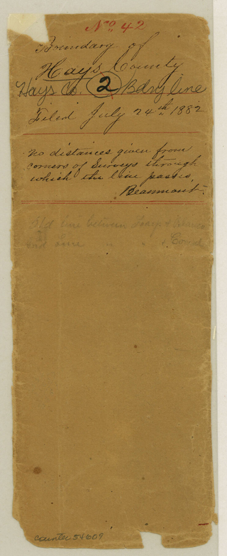
Hays County Boundary File 42
Boundary of Hays Co. - Comal
-
Map/Doc
54609
-
Collection
General Map Collection
-
Counties
Hays
-
Subjects
County Boundaries
-
Height x Width
9.1 x 3.7 inches
23.1 x 9.4 cm
Part of: General Map Collection
Matagorda County Sketch File 7a

Print $8.00
- Digital $50.00
Matagorda County Sketch File 7a
1890
Size 14.2 x 8.9 inches
Map/Doc 30740
Nueces County Rolled Sketch 27B

Print $108.00
- Digital $50.00
Nueces County Rolled Sketch 27B
1948
Size 9.8 x 15.1 inches
Map/Doc 47604
Flight Mission No. BRA-8M, Frame 84, Jefferson County

Print $20.00
- Digital $50.00
Flight Mission No. BRA-8M, Frame 84, Jefferson County
1953
Size 18.6 x 22.4 inches
Map/Doc 85604
Kimble County Working Sketch 82

Print $20.00
- Digital $50.00
Kimble County Working Sketch 82
1971
Size 43.3 x 27.7 inches
Map/Doc 70150
Sutton County Sketch File 62

Print $4.00
- Digital $50.00
Sutton County Sketch File 62
1959
Size 3.7 x 8.6 inches
Map/Doc 37564
Harris County Working Sketch 60

Print $20.00
- Digital $50.00
Harris County Working Sketch 60
1953
Size 31.8 x 35.2 inches
Map/Doc 65952
San Augustine County Rolled Sketch 3

Print $20.00
- Digital $50.00
San Augustine County Rolled Sketch 3
1969
Size 21.5 x 29.0 inches
Map/Doc 7555
McMullen County Working Sketch 11

Print $20.00
- Digital $50.00
McMullen County Working Sketch 11
1938
Size 26.8 x 31.6 inches
Map/Doc 70712
Brewster County Working Sketch Graphic Index, East Part, Sheet 1 (Sketches 1 to 111)

Print $20.00
- Digital $50.00
Brewster County Working Sketch Graphic Index, East Part, Sheet 1 (Sketches 1 to 111)
1952
Size 47.4 x 29.6 inches
Map/Doc 76476
Stephens County Rolled Sketch 3

Print $20.00
- Digital $50.00
Stephens County Rolled Sketch 3
1919
Size 34.9 x 19.6 inches
Map/Doc 7840
Concho County Working Sketch 3

Print $20.00
- Digital $50.00
Concho County Working Sketch 3
1918
Size 24.0 x 22.2 inches
Map/Doc 68185
Northeast Part of Crockett County

Print $20.00
- Digital $50.00
Northeast Part of Crockett County
1976
Size 31.4 x 41.0 inches
Map/Doc 77253
You may also like
Flight Mission No. CUG-1P, Frame 43, Kleberg County

Print $20.00
- Digital $50.00
Flight Mission No. CUG-1P, Frame 43, Kleberg County
1956
Size 18.6 x 22.4 inches
Map/Doc 86121
Nueces River, Corpus Christi Sheet No. 1-A

Print $6.00
- Digital $50.00
Nueces River, Corpus Christi Sheet No. 1-A
1938
Size 21.9 x 33.2 inches
Map/Doc 65090
Edwards County Working Sketch 139

Print $20.00
- Digital $50.00
Edwards County Working Sketch 139
Size 20.9 x 21.4 inches
Map/Doc 62184
Duval County Sketch File 68

Print $20.00
- Digital $50.00
Duval County Sketch File 68
Size 23.9 x 19.6 inches
Map/Doc 11407
Tyler County Sketch File 10

Print $4.00
- Digital $50.00
Tyler County Sketch File 10
Size 8.6 x 6.7 inches
Map/Doc 38648
Gonzales County Sketch File 10

Print $4.00
- Digital $50.00
Gonzales County Sketch File 10
1873
Size 8.4 x 5.2 inches
Map/Doc 24390
Nueces County Rolled Sketch 120

Print $100.00
Nueces County Rolled Sketch 120
1989
Size 11.2 x 10.7 inches
Map/Doc 9636
Trinity County, Texas

Print $20.00
- Digital $50.00
Trinity County, Texas
1879
Size 15.8 x 23.8 inches
Map/Doc 761

Flight Mission No. BRA-16M, Frame 172, Jefferson County

Print $20.00
- Digital $50.00
Flight Mission No. BRA-16M, Frame 172, Jefferson County
1953
Size 18.6 x 22.3 inches
Map/Doc 85770
Frio County Rolled Sketch 6

Print $20.00
- Digital $50.00
Frio County Rolled Sketch 6
1938
Size 42.7 x 32.6 inches
Map/Doc 76019
Menard County Working Sketch 29

Print $20.00
- Digital $50.00
Menard County Working Sketch 29
1967
Size 25.8 x 32.0 inches
Map/Doc 70976