Archer County Sketch File B
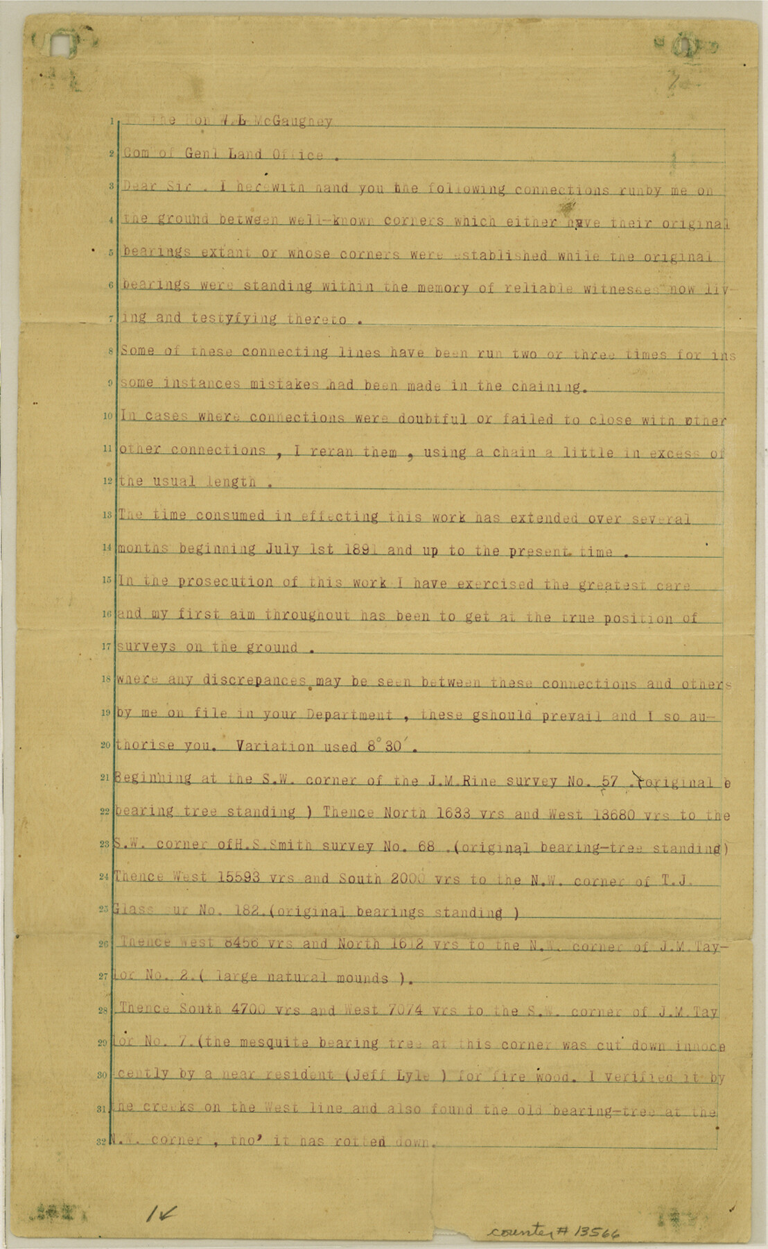
[Surveyor's report of connecting lines throughout whole county]
-
Map/Doc
13566
-
Collection
General Map Collection
-
Object Dates
1892/2/14 (Creation Date)
1892/3/8 (File Date)
-
People and Organizations
Thomas M. Cecil (Surveyor/Engineer)
N. Henderson (Surveyor/Engineer)
-
Counties
Archer
-
Subjects
Surveying Sketch File
-
Height x Width
14.2 x 8.8 inches
36.1 x 22.4 cm
-
Medium
paper, print
-
Comments
See Archer County Sketch File B-1 (10370) for accompanying sketch.
-
Features
North Fork of Little Wichita River
Little Wichita River
Archer City and Dundee Road
Archer City Road
Dundee Road
Holiday Creek
Wichita River
Related maps
Archer County Sketch File B-1

Print $40.00
- Digital $50.00
Archer County Sketch File B-1
Size 34.5 x 38.8 inches
Map/Doc 10370
Part of: General Map Collection
Flight Mission No. CGI-4N, Frame 189, Cameron County

Print $20.00
- Digital $50.00
Flight Mission No. CGI-4N, Frame 189, Cameron County
1955
Size 18.5 x 22.2 inches
Map/Doc 84692
Mason County Sketch File 21

Print $6.00
- Digital $50.00
Mason County Sketch File 21
Size 15.7 x 10.9 inches
Map/Doc 30717
Live Oak County

Print $40.00
- Digital $50.00
Live Oak County
1899
Size 52.3 x 38.5 inches
Map/Doc 66905
Harris County Working Sketch 95

Print $20.00
- Digital $50.00
Harris County Working Sketch 95
1978
Size 26.6 x 44.1 inches
Map/Doc 65987
Austin Street Map & Guide

Digital $50.00
Austin Street Map & Guide
1999
Size 35.4 x 23.2 inches
Map/Doc 94094
Brazoria County Sketch File 44

Print $30.00
- Digital $50.00
Brazoria County Sketch File 44
1946
Size 11.3 x 8.9 inches
Map/Doc 15068
Pecos County Working Sketch 104

Print $40.00
- Digital $50.00
Pecos County Working Sketch 104
1971
Size 63.1 x 26.9 inches
Map/Doc 71577
Starr County Rolled Sketch 20

Print $20.00
- Digital $50.00
Starr County Rolled Sketch 20
1921
Size 23.6 x 15.4 inches
Map/Doc 7804
Edwards County Rolled Sketch 15

Print $20.00
- Digital $50.00
Edwards County Rolled Sketch 15
1893
Size 35.5 x 26.4 inches
Map/Doc 5803
Map of subdivision of submerged land in the Gulf of Mexico fronting on Matagorda Island and Peninsula

Print $40.00
- Digital $50.00
Map of subdivision of submerged land in the Gulf of Mexico fronting on Matagorda Island and Peninsula
1940
Size 28.2 x 61.3 inches
Map/Doc 2929
Ellis County Sketch File 14

Print $40.00
- Digital $50.00
Ellis County Sketch File 14
1861
Size 12.9 x 16.1 inches
Map/Doc 21854
Refugio County Sketch File 12

Print $4.00
- Digital $50.00
Refugio County Sketch File 12
Size 8.0 x 12.8 inches
Map/Doc 35263
You may also like
McCulloch County Working Sketch 3

Print $20.00
- Digital $50.00
McCulloch County Working Sketch 3
1951
Size 30.9 x 36.8 inches
Map/Doc 70678
Real County Working Sketch 90

Print $20.00
- Digital $50.00
Real County Working Sketch 90
1991
Size 16.7 x 22.8 inches
Map/Doc 71982
[Bastrop District]
![16941, [Bastrop District], General Map Collection](https://historictexasmaps.com/wmedia_w700/maps/16941-1.tif.jpg)
Print $40.00
- Digital $50.00
[Bastrop District]
1838
Size 67.3 x 44.2 inches
Map/Doc 16941
Flight Mission No. CRK-7P, Frame 79, Refugio County

Print $20.00
- Digital $50.00
Flight Mission No. CRK-7P, Frame 79, Refugio County
1956
Size 18.2 x 22.1 inches
Map/Doc 86950
Victoria County Sketch File 8

Print $2.00
- Digital $50.00
Victoria County Sketch File 8
Size 5.7 x 5.6 inches
Map/Doc 39524
Flight Mission No. CUG-1P, Frame 49, Kleberg County

Print $20.00
- Digital $50.00
Flight Mission No. CUG-1P, Frame 49, Kleberg County
1956
Size 18.5 x 22.4 inches
Map/Doc 86127

Brown County Working Sketch 11

Print $20.00
- Digital $50.00
Brown County Working Sketch 11
1983
Size 45.5 x 43.1 inches
Map/Doc 67776
Flight Mission No. DQN-1K, Frame 104, Calhoun County

Print $20.00
- Digital $50.00
Flight Mission No. DQN-1K, Frame 104, Calhoun County
1953
Size 18.4 x 22.1 inches
Map/Doc 84171
Kaufman County, Texas

Print $20.00
- Digital $50.00
Kaufman County, Texas
1871
Size 24.9 x 18.8 inches
Map/Doc 735
Anderson County Rolled Sketch 14

Print $20.00
- Digital $50.00
Anderson County Rolled Sketch 14
1997
Size 30.1 x 36.5 inches
Map/Doc 77159
[Surveys along the Trinity River]
![298, [Surveys along the Trinity River], General Map Collection](https://historictexasmaps.com/wmedia_w700/maps/298.tif.jpg)
Print $2.00
- Digital $50.00
[Surveys along the Trinity River]
Size 6.3 x 9.2 inches
Map/Doc 298