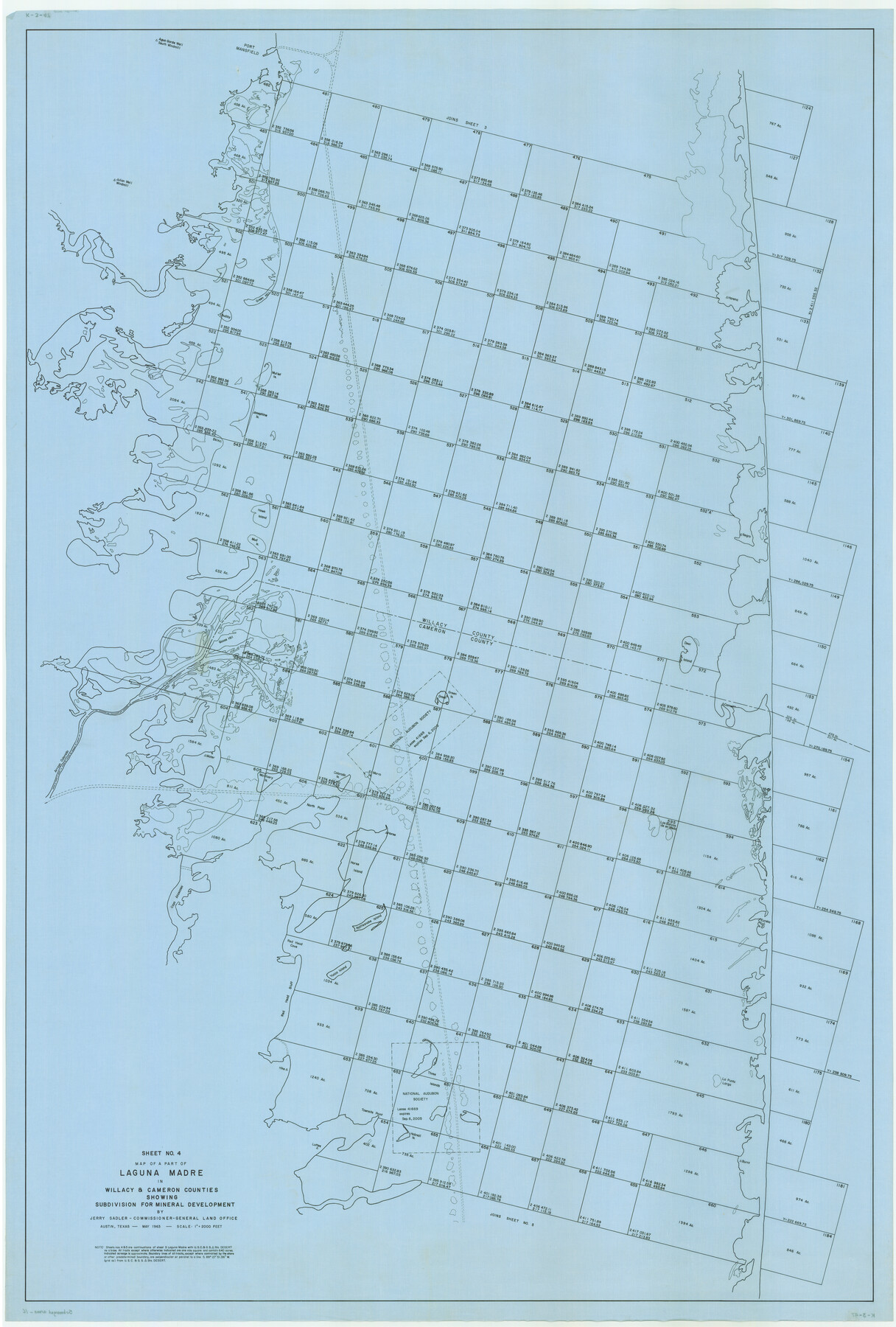
Map of a part of Laguna Madre showing subdivision for mineral development
K-3-44; K-3-45; K-3-46; K-3-47; K-3-48
-
Map/Doc
2916
-
Collection
General Map Collection
-
Object Dates
1963 (Creation Date)
-
People and Organizations
General Land Office (Publisher)
-
Counties
Willacy Cameron
-
Subjects
Energy Offshore Submerged Area Gulf of Mexico
-
Height x Width
68.1 x 46.0 inches
173.0 x 116.8 cm
Part of: General Map Collection

Moore County Sketch File 4

Print $20.00
- Digital $50.00
Moore County Sketch File 4
1895
Size 17.2 x 29.4 inches
Map/Doc 42127
Crockett County Working Sketch 53

Print $20.00
- Digital $50.00
Crockett County Working Sketch 53
1948
Size 24.2 x 27.7 inches
Map/Doc 68386
Somervell County Sketch File 7

Print $8.00
- Digital $50.00
Somervell County Sketch File 7
1987
Size 11.4 x 8.9 inches
Map/Doc 36850
Intracoastal Waterway - Galveston Bay to West Bay including Galveston Bay Entrance

Print $20.00
- Digital $50.00
Intracoastal Waterway - Galveston Bay to West Bay including Galveston Bay Entrance
1961
Size 26.7 x 38.7 inches
Map/Doc 69934
Val Verde County Working Sketch 117

Print $20.00
- Digital $50.00
Val Verde County Working Sketch 117
1993
Size 17.5 x 24.4 inches
Map/Doc 82848
Bell County Sketch File 19

Print $4.00
- Digital $50.00
Bell County Sketch File 19
Size 7.6 x 7.7 inches
Map/Doc 14402
La Salle County Rolled Sketch 14B

Print $20.00
- Digital $50.00
La Salle County Rolled Sketch 14B
Size 20.7 x 23.0 inches
Map/Doc 6578
Navigation Maps of Gulf Intracoastal Waterway, Port Arthur to Brownsville, Texas

Print $4.00
- Digital $50.00
Navigation Maps of Gulf Intracoastal Waterway, Port Arthur to Brownsville, Texas
1951
Size 16.7 x 21.3 inches
Map/Doc 65444
Map of Henderson Co.

Print $40.00
- Digital $50.00
Map of Henderson Co.
1886
Size 27.8 x 57.6 inches
Map/Doc 3663
Upshur County

Print $20.00
- Digital $50.00
Upshur County
1945
Size 39.8 x 35.8 inches
Map/Doc 73308
Schleicher County Sketch File 24

Print $35.00
- Digital $50.00
Schleicher County Sketch File 24
1937
Size 10.1 x 14.8 inches
Map/Doc 36516
You may also like
Kent County Rolled Sketch 6

Print $20.00
- Digital $50.00
Kent County Rolled Sketch 6
Size 39.0 x 36.5 inches
Map/Doc 6476
[Blocks C4, SI, and JK]
![90774, [Blocks C4, SI, and JK], Twichell Survey Records](https://historictexasmaps.com/wmedia_w700/maps/90774-1.tif.jpg)
Print $20.00
- Digital $50.00
[Blocks C4, SI, and JK]
Size 16.1 x 16.3 inches
Map/Doc 90774
Flight Mission No. CRE-1R, Frame 65, Jackson County

Print $20.00
- Digital $50.00
Flight Mission No. CRE-1R, Frame 65, Jackson County
1956
Size 18.6 x 22.3 inches
Map/Doc 85328
[Texas & Pacific Railway through Callahan County]
![64236, [Texas & Pacific Railway through Callahan County], General Map Collection](https://historictexasmaps.com/wmedia_w700/maps/64236.tif.jpg)
Print $20.00
- Digital $50.00
[Texas & Pacific Railway through Callahan County]
1918
Size 22.9 x 8.8 inches
Map/Doc 64236
[Surveys near Lake Soda made under G.W. Smyth, Commissioner]
![73, [Surveys near Lake Soda made under G.W. Smyth, Commissioner], General Map Collection](https://historictexasmaps.com/wmedia_w700/maps/73.tif.jpg)
Print $20.00
- Digital $50.00
[Surveys near Lake Soda made under G.W. Smyth, Commissioner]
1835
Size 16.0 x 19.3 inches
Map/Doc 73

Lubbock County

Print $20.00
- Digital $50.00
Lubbock County
1892
Size 20.1 x 19.3 inches
Map/Doc 3828
Lampasas County Boundary File 3

Print $10.00
- Digital $50.00
Lampasas County Boundary File 3
Size 8.4 x 7.3 inches
Map/Doc 56101
Leon County Sketch File 23

Print $12.00
- Digital $50.00
Leon County Sketch File 23
1932
Size 11.1 x 8.7 inches
Map/Doc 29775
Sherman County Rolled Sketch 4

Print $20.00
- Digital $50.00
Sherman County Rolled Sketch 4
Size 23.1 x 31.7 inches
Map/Doc 7786
The Republic County of Sabine. December 29, 1845

Print $20.00
The Republic County of Sabine. December 29, 1845
2020
Size 17.6 x 21.7 inches
Map/Doc 96270
Fayette County Sketch File 4

Print $4.00
- Digital $50.00
Fayette County Sketch File 4
Size 11.7 x 7.9 inches
Map/Doc 22504