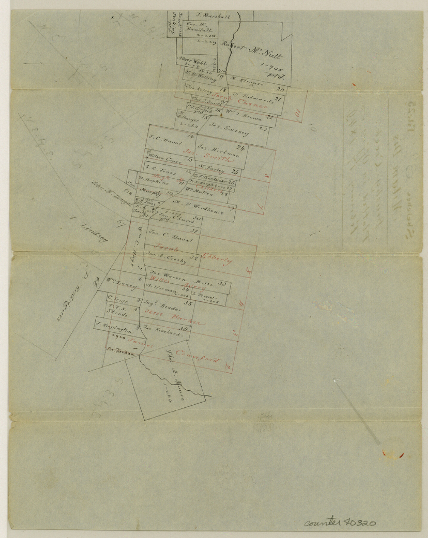
Williamson County Sketch File 8a
[Office sketch of surveys on Brushy Creek southeast from Georgetown]
-
Map/Doc
40320
-
Collection
General Map Collection
-
Object Dates
2/17/1849 (Creation Date)
-
Counties
Williamson
-
Subjects
Surveying Sketch File
-
Height x Width
10.4 x 8.3 inches
26.4 x 21.1 cm
-
Medium
paper, manuscript
-
Features
Brushy Creek
Part of: General Map Collection
Panola County Working Sketch 23

Print $20.00
- Digital $50.00
Panola County Working Sketch 23
1951
Map/Doc 71432
Cass County Sketch File 4

Print $6.00
- Digital $50.00
Cass County Sketch File 4
1853
Size 8.2 x 11.2 inches
Map/Doc 17398
Crane County Sketch File 24

Print $20.00
- Digital $50.00
Crane County Sketch File 24
Size 23.0 x 17.0 inches
Map/Doc 11212
Dimmit County Working Sketch 35

Print $20.00
- Digital $50.00
Dimmit County Working Sketch 35
1961
Size 22.4 x 24.4 inches
Map/Doc 68696
Bell County Working Sketch 9

Print $20.00
- Digital $50.00
Bell County Working Sketch 9
1954
Size 32.3 x 27.9 inches
Map/Doc 67349
Donley County Working Sketch 1

Print $20.00
- Digital $50.00
Donley County Working Sketch 1
1914
Size 19.0 x 19.7 inches
Map/Doc 68734
Runnels County Sketch File 34

Print $20.00
Runnels County Sketch File 34
1889
Size 16.6 x 26.7 inches
Map/Doc 12265
Burnet County Working Sketch 25

Print $20.00
- Digital $50.00
Burnet County Working Sketch 25
2000
Size 24.2 x 30.3 inches
Map/Doc 67868
Reagan County Working Sketch 46b

Print $20.00
- Digital $50.00
Reagan County Working Sketch 46b
1987
Size 31.4 x 45.2 inches
Map/Doc 71889
Franklin County Sketch File 2a

Print $6.00
- Digital $50.00
Franklin County Sketch File 2a
1857
Size 8.6 x 10.5 inches
Map/Doc 23012
Edwards County Working Sketch 120

Print $40.00
- Digital $50.00
Edwards County Working Sketch 120
1975
Size 25.0 x 48.9 inches
Map/Doc 68996
Moore County Working Sketch 17

Print $20.00
- Digital $50.00
Moore County Working Sketch 17
1982
Size 37.0 x 36.2 inches
Map/Doc 71199
You may also like
Angelina County Sketch File 11b

Print $6.00
- Digital $50.00
Angelina County Sketch File 11b
1859
Size 17.7 x 8.3 inches
Map/Doc 12944
Palo Pinto County Sketch File 21

Print $20.00
- Digital $50.00
Palo Pinto County Sketch File 21
1896
Size 18.5 x 17.5 inches
Map/Doc 12133
This is a true copy of Peck's field book No. 7 pages 22 to 27, except classification of lands

Print $40.00
- Digital $50.00
This is a true copy of Peck's field book No. 7 pages 22 to 27, except classification of lands
Size 5.4 x 54.2 inches
Map/Doc 89726
Marion County Working Sketch 15

Print $20.00
- Digital $50.00
Marion County Working Sketch 15
1954
Size 37.3 x 28.8 inches
Map/Doc 70791
Flight Mission No. DCL-5C, Frame 69, Kenedy County

Print $20.00
- Digital $50.00
Flight Mission No. DCL-5C, Frame 69, Kenedy County
1943
Size 18.5 x 22.3 inches
Map/Doc 85852
Jack County Rolled Sketch 3

Print $20.00
- Digital $50.00
Jack County Rolled Sketch 3
1985
Size 30.3 x 27.5 inches
Map/Doc 6333
Hemphill County Sketch File 2

Print $8.00
- Digital $50.00
Hemphill County Sketch File 2
1900
Size 10.3 x 8.4 inches
Map/Doc 26281
[General Highway Map of] Bexar County, Sheet 1 of 2
![76288, [General Highway Map of] Bexar County, Sheet 1 of 2, Texas State Library and Archives](https://historictexasmaps.com/wmedia_w700/maps/76288.tif.jpg)
Print $20.00
[General Highway Map of] Bexar County, Sheet 1 of 2
1940
Size 18.5 x 25.1 inches
Map/Doc 76288
Calhoun County Rolled Sketch 2

Print $20.00
- Digital $50.00
Calhoun County Rolled Sketch 2
Size 23.1 x 22.4 inches
Map/Doc 5360
Fannin County Working Sketch 6

Print $20.00
- Digital $50.00
Fannin County Working Sketch 6
1939
Size 11.4 x 18.0 inches
Map/Doc 69160
Flight Mission No. CGI-3N, Frame 48, Cameron County

Print $20.00
- Digital $50.00
Flight Mission No. CGI-3N, Frame 48, Cameron County
1954
Size 18.7 x 22.2 inches
Map/Doc 84554
Matagorda County Boundary File 1a

Print $8.00
- Digital $50.00
Matagorda County Boundary File 1a
Size 14.2 x 8.6 inches
Map/Doc 56889