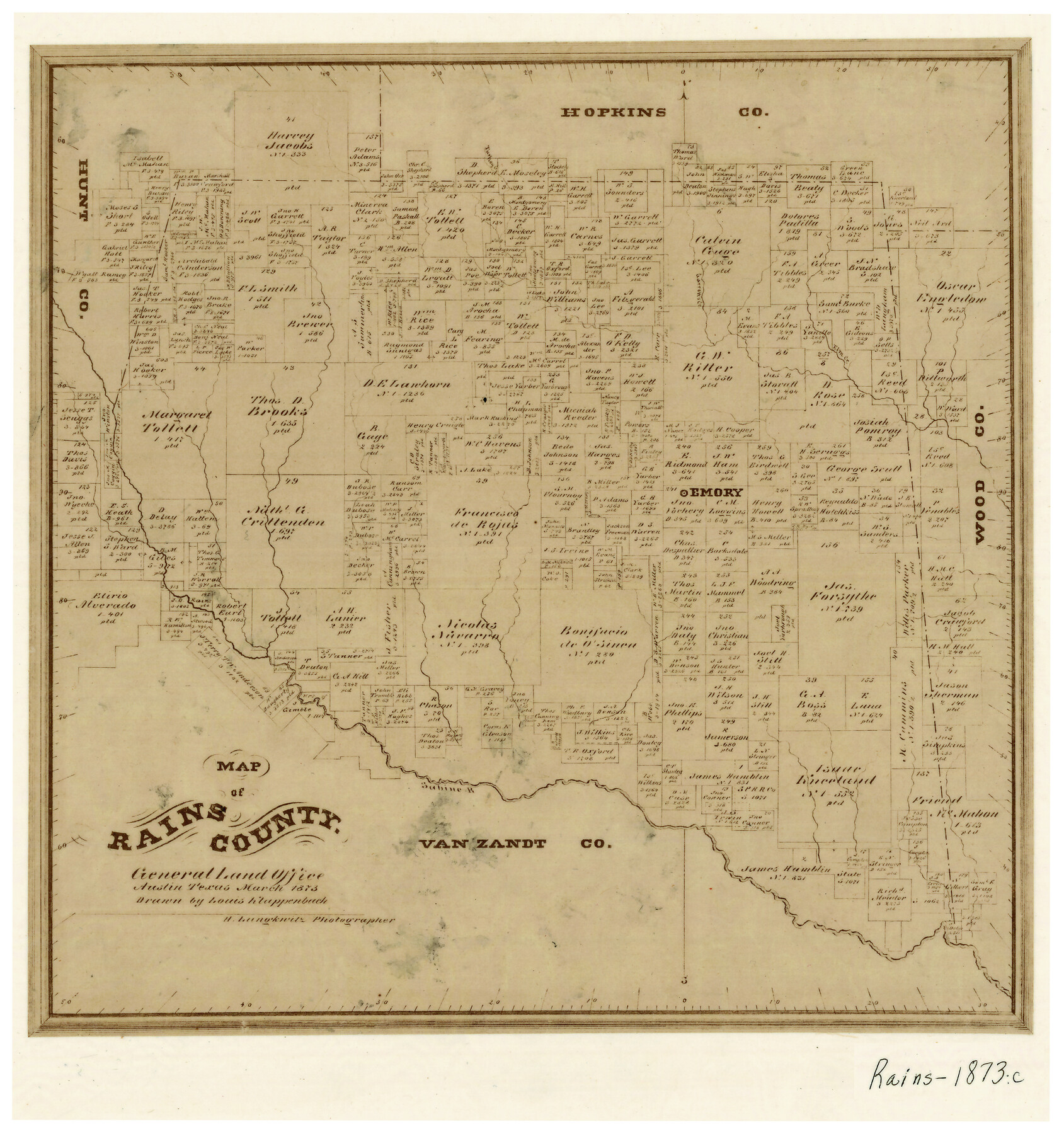
Map of Rains County
-
Map/Doc
4618
-
Collection
General Map Collection
-
Object Dates
3/1873 (Creation Date)
-
People and Organizations
L. Klappenbach (Draftsman)
Herman Lungkwitz (Draftsman)
-
Counties
Rains
-
Subjects
County
-
Height x Width
12.5 x 11.6 inches
31.8 x 29.5 cm
-
Features
Turkey Creek
Elm Creek
Garrett's Creek
Emory
Sabine River
Part of: General Map Collection
Lynn County Rolled Sketch S

Print $20.00
- Digital $50.00
Lynn County Rolled Sketch S
Size 21.1 x 38.7 inches
Map/Doc 6654
Flight Mission No. CRK-5P, Frame 154, Refugio County

Print $20.00
- Digital $50.00
Flight Mission No. CRK-5P, Frame 154, Refugio County
1956
Size 18.6 x 22.5 inches
Map/Doc 86935
Drainage Basins of Texas Streams

Print $20.00
- Digital $50.00
Drainage Basins of Texas Streams
Size 17.0 x 19.3 inches
Map/Doc 65269
Flight Mission No. CUG-1P, Frame 20, Kleberg County

Print $20.00
- Digital $50.00
Flight Mission No. CUG-1P, Frame 20, Kleberg County
1956
Size 18.6 x 22.4 inches
Map/Doc 86110
Montgomery County Rolled Sketch 42

Print $20.00
- Digital $50.00
Montgomery County Rolled Sketch 42
1939
Size 14.1 x 20.3 inches
Map/Doc 6815
Harris County Rolled Sketch 30

Print $20.00
- Digital $50.00
Harris County Rolled Sketch 30
1889
Size 30.4 x 35.1 inches
Map/Doc 6096
United States Great Lakes and adjacent waterways

Print $20.00
- Digital $50.00
United States Great Lakes and adjacent waterways
Size 20.8 x 42.7 inches
Map/Doc 76122
Orange County Working Sketch 30

Print $20.00
- Digital $50.00
Orange County Working Sketch 30
1953
Size 19.7 x 34.2 inches
Map/Doc 71362
Hunt County Boundary File 3

Print $12.00
- Digital $50.00
Hunt County Boundary File 3
Size 10.5 x 8.4 inches
Map/Doc 55208
Reeves County Working Sketch 34

Print $40.00
- Digital $50.00
Reeves County Working Sketch 34
1970
Size 37.9 x 48.9 inches
Map/Doc 63477
Current Miscellaneous File 37

Print $4.00
- Digital $50.00
Current Miscellaneous File 37
Size 13.2 x 8.7 inches
Map/Doc 73956
Hutchinson County Sketch File 8

Print $8.00
- Digital $50.00
Hutchinson County Sketch File 8
1882
Size 14.2 x 8.8 inches
Map/Doc 27205
You may also like
Val Verde County Sketch File XXX5

Print $40.00
- Digital $50.00
Val Verde County Sketch File XXX5
Size 13.2 x 13.4 inches
Map/Doc 39100
Morris County Rolled Sketch 2A

Print $20.00
- Digital $50.00
Morris County Rolled Sketch 2A
Size 24.0 x 18.8 inches
Map/Doc 10274
Map of surveys 189 & 190 T. C. R.R. Co. in Travis County, Texas

Print $20.00
- Digital $50.00
Map of surveys 189 & 190 T. C. R.R. Co. in Travis County, Texas
1915
Size 16.1 x 24.0 inches
Map/Doc 5079
Detail Sketch of A.B. Robertson's Ranch and J.W. James' Ranch situated in Garza and Crosby Counties, Texas

Print $40.00
- Digital $50.00
Detail Sketch of A.B. Robertson's Ranch and J.W. James' Ranch situated in Garza and Crosby Counties, Texas
Size 51.8 x 34.1 inches
Map/Doc 93030
Texas and part of Mexico & the United States, showing the route of the first Santa Fe Expedition

Print $20.00
- Digital $50.00
Texas and part of Mexico & the United States, showing the route of the first Santa Fe Expedition
1844
Size 18.1 x 13.2 inches
Map/Doc 94035
[R. M. Thompson Block T2 and John H. Stephens Block S2 Conflict]
![91056, [R. M. Thompson Block T2 and John H. Stephens Block S2 Conflict], Twichell Survey Records](https://historictexasmaps.com/wmedia_w700/maps/91056-1.tif.jpg)
Print $20.00
- Digital $50.00
[R. M. Thompson Block T2 and John H. Stephens Block S2 Conflict]
Size 20.9 x 30.6 inches
Map/Doc 91056
Roberts County Sketch File 7

Print $16.00
- Digital $50.00
Roberts County Sketch File 7
1992
Size 14.3 x 8.8 inches
Map/Doc 35316
Eastland County Working Sketch 14

Print $20.00
- Digital $50.00
Eastland County Working Sketch 14
1919
Size 18.2 x 17.1 inches
Map/Doc 68795
Colorado County Working Sketch Graphic Index

Print $40.00
- Digital $50.00
Colorado County Working Sketch Graphic Index
1946
Size 52.7 x 42.4 inches
Map/Doc 76500
Flight Mission No. CRC-4R, Frame 64, Chambers County

Print $20.00
- Digital $50.00
Flight Mission No. CRC-4R, Frame 64, Chambers County
1956
Size 18.7 x 22.3 inches
Map/Doc 84868
[T. C. & S. F. Block K11, Capitol Leagues 367, 373, 374, and Blocks D and B]
![90542, [T. C. & S. F. Block K11, Capitol Leagues 367, 373, 374, and Blocks D and B], Twichell Survey Records](https://historictexasmaps.com/wmedia_w700/maps/90542-1.tif.jpg)
Print $3.00
- Digital $50.00
[T. C. & S. F. Block K11, Capitol Leagues 367, 373, 374, and Blocks D and B]
Size 9.8 x 13.5 inches
Map/Doc 90542
Concho County Working Sketch 9

Print $20.00
- Digital $50.00
Concho County Working Sketch 9
1950
Size 20.0 x 14.6 inches
Map/Doc 68191