Hutchinson County Sketch File 8
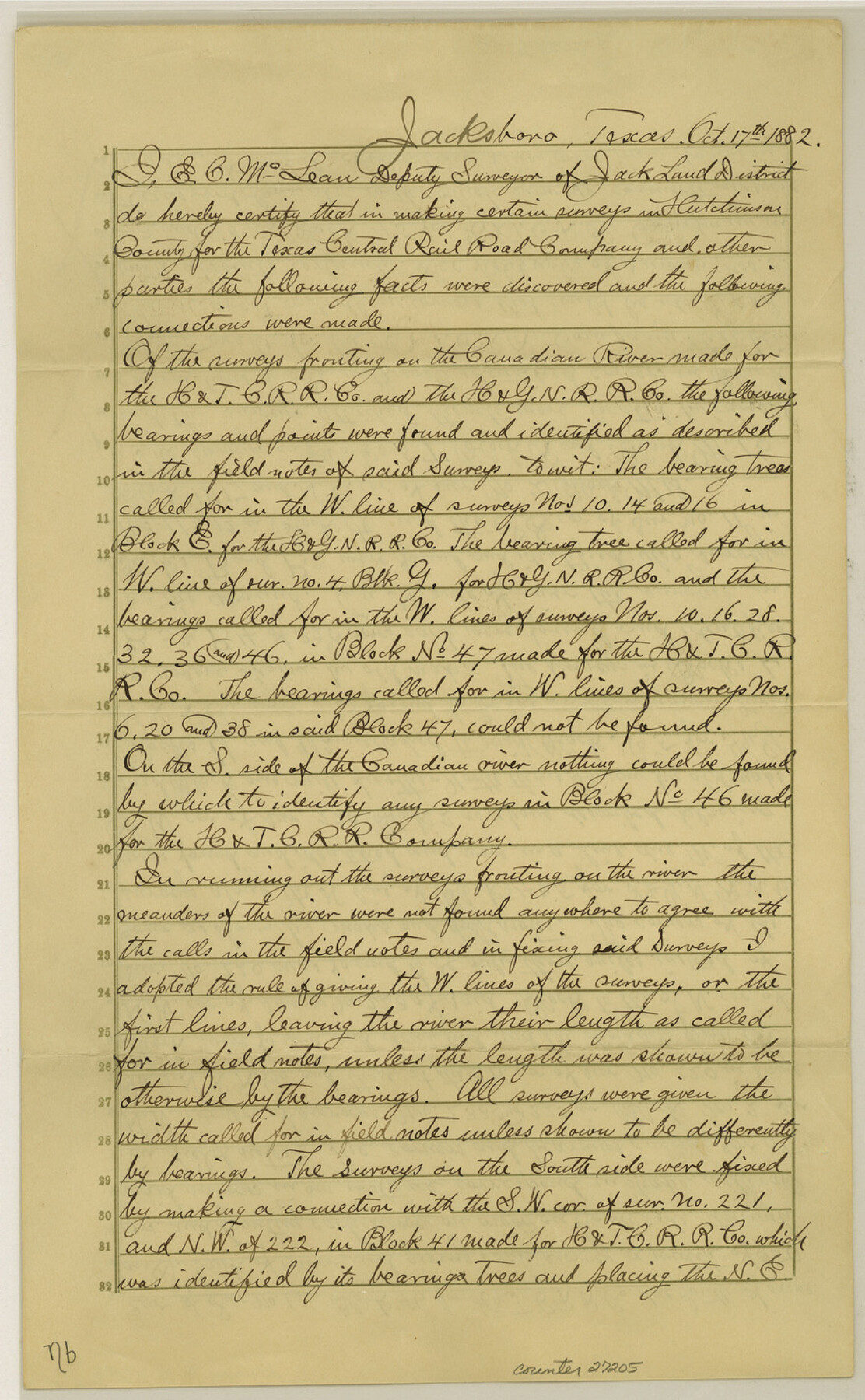
[Surveyor's report regarding area around Canadian River]
-
Map/Doc
27205
-
Collection
General Map Collection
-
Object Dates
10/17/1882 (Creation Date)
11/8/1882 (File Date)
10/17/1882 (Correspondence Date)
7/26/1882 (File Date)
-
People and Organizations
E.C. McLean (Surveyor/Engineer)
-
Counties
Hutchinson Hansford
-
Subjects
Surveying Sketch File
-
Height x Width
14.2 x 8.8 inches
36.1 x 22.4 cm
-
Medium
paper, manuscript
-
Features
Canadian River
Part of: General Map Collection
Jefferson County Rolled Sketch 39

Print $20.00
- Digital $50.00
Jefferson County Rolled Sketch 39
1885
Size 31.2 x 33.9 inches
Map/Doc 9299
Live Oak County Sketch File 4

Print $20.00
- Digital $50.00
Live Oak County Sketch File 4
1858
Size 16.3 x 19.2 inches
Map/Doc 12006
Jack County Working Sketch 9

Print $20.00
- Digital $50.00
Jack County Working Sketch 9
1955
Size 35.3 x 29.9 inches
Map/Doc 66435
Map of San Saba County

Print $20.00
- Digital $50.00
Map of San Saba County
1858
Size 21.6 x 23.5 inches
Map/Doc 4019
Jefferson County NRC Article 33.136 Sketch 6

Print $4.00
- Digital $50.00
Jefferson County NRC Article 33.136 Sketch 6
2005
Size 14.1 x 8.6 inches
Map/Doc 83171
Current Miscellaneous File 39

Print $20.00
- Digital $50.00
Current Miscellaneous File 39
Size 11.2 x 8.8 inches
Map/Doc 73962
Map of a part of Laguna Madre showing subdivision for mineral development

Print $20.00
- Digital $50.00
Map of a part of Laguna Madre showing subdivision for mineral development
1948
Size 37.4 x 27.7 inches
Map/Doc 2914
Starr County Sketch File 28

Print $12.00
- Digital $50.00
Starr County Sketch File 28
1933
Size 11.2 x 8.8 inches
Map/Doc 36948
Report Upon the Resurvey and Location of the Boundary Line between the States of Texas and New Mexico

Print $1706.00
Report Upon the Resurvey and Location of the Boundary Line between the States of Texas and New Mexico
1911
Map/Doc 81686
McMullen County Working Sketch 1

Print $20.00
- Digital $50.00
McMullen County Working Sketch 1
1911
Size 20.9 x 13.1 inches
Map/Doc 70702
Sutton County Rolled Sketch 57

Print $40.00
- Digital $50.00
Sutton County Rolled Sketch 57
1958
Size 40.1 x 51.1 inches
Map/Doc 10662
[Map to illustrate possible mineral resources on the lands belonging to the University of Texas]
![62963, [Map to illustrate possible mineral resources on the lands belonging to the University of Texas], General Map Collection](https://historictexasmaps.com/wmedia_w700/maps/62963.tif.jpg)
Print $2.00
- Digital $50.00
[Map to illustrate possible mineral resources on the lands belonging to the University of Texas]
Size 10.2 x 7.7 inches
Map/Doc 62963
You may also like
Jefferson County Sketch File 9

Print $40.00
- Digital $50.00
Jefferson County Sketch File 9
1860
Size 12.6 x 15.2 inches
Map/Doc 28123
Map of Hale County, Texas

Print $2.00
- Digital $50.00
Map of Hale County, Texas
1903
Size 9.2 x 11.6 inches
Map/Doc 90698
Denton County Sketch File 43

Print $20.00
- Digital $50.00
Denton County Sketch File 43
2006
Size 11.0 x 8.5 inches
Map/Doc 83610
Hays County Working Sketch 8

Print $20.00
- Digital $50.00
Hays County Working Sketch 8
1942
Size 27.1 x 30.9 inches
Map/Doc 66082
Mitchell County Boundary File 66

Print $13.00
- Digital $50.00
Mitchell County Boundary File 66
Size 7.9 x 3.7 inches
Map/Doc 57372
Coast of Texas from head of East Bay Galveston Harbor to Sabine Pass

Print $40.00
- Digital $50.00
Coast of Texas from head of East Bay Galveston Harbor to Sabine Pass
1882
Size 32.3 x 53.9 inches
Map/Doc 69840
Kinney County Boundary File 1a

Print $73.00
- Digital $50.00
Kinney County Boundary File 1a
Size 8.5 x 43.2 inches
Map/Doc 64946
Duval County Working Sketch 13

Print $20.00
- Digital $50.00
Duval County Working Sketch 13
1938
Size 27.8 x 32.5 inches
Map/Doc 68726
General Highway Map, Matagorda County, Texas

Print $20.00
General Highway Map, Matagorda County, Texas
1939
Size 24.7 x 18.3 inches
Map/Doc 79187
Angelina County Sketch File 24

Print $8.00
- Digital $50.00
Angelina County Sketch File 24
1893
Size 8.9 x 5.6 inches
Map/Doc 13065
Hardeman County Aerial Photograph Index Sheet 3

Print $20.00
- Digital $50.00
Hardeman County Aerial Photograph Index Sheet 3
1950
Size 20.3 x 17.0 inches
Map/Doc 83699
Goliad County Sketch File Y

Print $20.00
- Digital $50.00
Goliad County Sketch File Y
1894
Size 14.1 x 12.1 inches
Map/Doc 11574