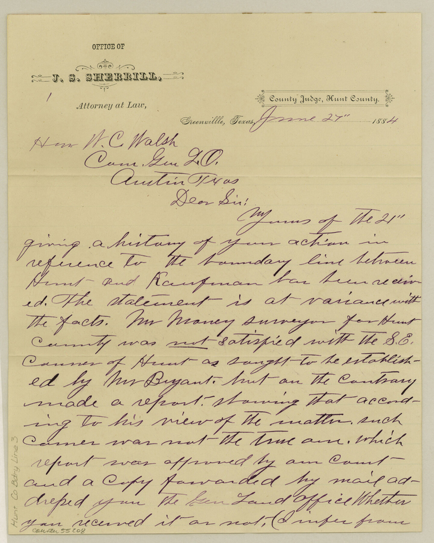
Hunt County Boundary File 3
[Letter regarding Hunt-Kaufman Boundary line]
-
Map/Doc
55208
-
Collection
General Map Collection
-
Counties
Hunt
-
Subjects
County Boundaries
-
Height x Width
10.5 x 8.4 inches
26.7 x 21.3 cm
Part of: General Map Collection
Hardin County Sketch File 3

Print $4.00
- Digital $50.00
Hardin County Sketch File 3
Size 7.7 x 4.6 inches
Map/Doc 25086
Brooks County Sketch File 8

Print $40.00
- Digital $50.00
Brooks County Sketch File 8
1946
Size 26.5 x 38.4 inches
Map/Doc 11018
Pecos County Sketch File 42

Print $30.00
- Digital $50.00
Pecos County Sketch File 42
1919
Size 9.1 x 8.0 inches
Map/Doc 33735
Tom Green County Sketch File 72

Print $20.00
- Digital $50.00
Tom Green County Sketch File 72
1949
Size 24.3 x 28.5 inches
Map/Doc 12448
Scarborough's Map of the New England States Vermont, New Hampshire, Maine, Massachusetts, Rhode Island and Connecticut

Print $40.00
- Digital $50.00
Scarborough's Map of the New England States Vermont, New Hampshire, Maine, Massachusetts, Rhode Island and Connecticut
1910
Size 58.3 x 40.1 inches
Map/Doc 97106
Chambers County Rolled Sketch 30

Print $20.00
- Digital $50.00
Chambers County Rolled Sketch 30
1952
Size 26.7 x 37.9 inches
Map/Doc 5430
Culberson County Rolled Sketch 11
Print $20.00
- Digital $50.00
Culberson County Rolled Sketch 11
1898
Size 25.6 x 45.9 inches
Map/Doc 5648
Liberty County Rolled Sketch E

Print $20.00
- Digital $50.00
Liberty County Rolled Sketch E
Size 20.8 x 31.0 inches
Map/Doc 9439
Galveston Island

Print $20.00
- Digital $50.00
Galveston Island
1837
Size 23.5 x 40.0 inches
Map/Doc 1954
Brewster County Rolled Sketch 93

Print $20.00
- Digital $50.00
Brewster County Rolled Sketch 93
1935
Size 24.1 x 43.1 inches
Map/Doc 5251
Sterling County Sketch File D

Print $8.00
- Digital $50.00
Sterling County Sketch File D
Size 11.2 x 8.6 inches
Map/Doc 37157
Gaines County Sketch File 1

Print $20.00
- Digital $50.00
Gaines County Sketch File 1
Size 19.1 x 30.7 inches
Map/Doc 11521
You may also like
Right of Way and Track Map, Houston & Texas Central R.R. operated by the T. and N. O. R.R., Fort Worth Branch

Print $40.00
- Digital $50.00
Right of Way and Track Map, Houston & Texas Central R.R. operated by the T. and N. O. R.R., Fort Worth Branch
1918
Size 30.7 x 57.3 inches
Map/Doc 64782
General Highway Map, Wilson County, Texas

Print $20.00
General Highway Map, Wilson County, Texas
1940
Size 18.2 x 24.8 inches
Map/Doc 79282
Trinity County Working Sketch Graphic Index

Print $20.00
- Digital $50.00
Trinity County Working Sketch Graphic Index
1946
Size 41.3 x 41.6 inches
Map/Doc 76718
Coryell County Sketch File 7

Print $23.00
- Digital $50.00
Coryell County Sketch File 7
1859
Size 8.3 x 12.7 inches
Map/Doc 19349
Chambers County Sketch File 22

Print $8.00
- Digital $50.00
Chambers County Sketch File 22
Size 12.2 x 7.6 inches
Map/Doc 17594
United States - Gulf Coast - From Latitude 26° 33' to the Rio Grande Texas

Print $20.00
- Digital $50.00
United States - Gulf Coast - From Latitude 26° 33' to the Rio Grande Texas
1913
Size 27.9 x 18.4 inches
Map/Doc 72834
El Nuevo México y Tierras Adyacentes Levantado para la Demarcación de los Límites de los Dominios Españoles y de los Estados Unidos

El Nuevo México y Tierras Adyacentes Levantado para la Demarcación de los Límites de los Dominios Españoles y de los Estados Unidos
1811
Size 9.4 x 12.6 inches
Map/Doc 94445
Kaufman County Working Sketch 9

Print $20.00
- Digital $50.00
Kaufman County Working Sketch 9
1988
Size 35.9 x 29.8 inches
Map/Doc 66672

Hutchinson County Rolled Sketch 40

Print $20.00
- Digital $50.00
Hutchinson County Rolled Sketch 40
1981
Size 26.0 x 37.5 inches
Map/Doc 6302
Caldwell County

Print $20.00
- Digital $50.00
Caldwell County
1935
Size 39.6 x 43.7 inches
Map/Doc 1791
Map of Scurry County

Print $20.00
- Digital $50.00
Map of Scurry County
1899
Size 39.7 x 33.6 inches
Map/Doc 16812