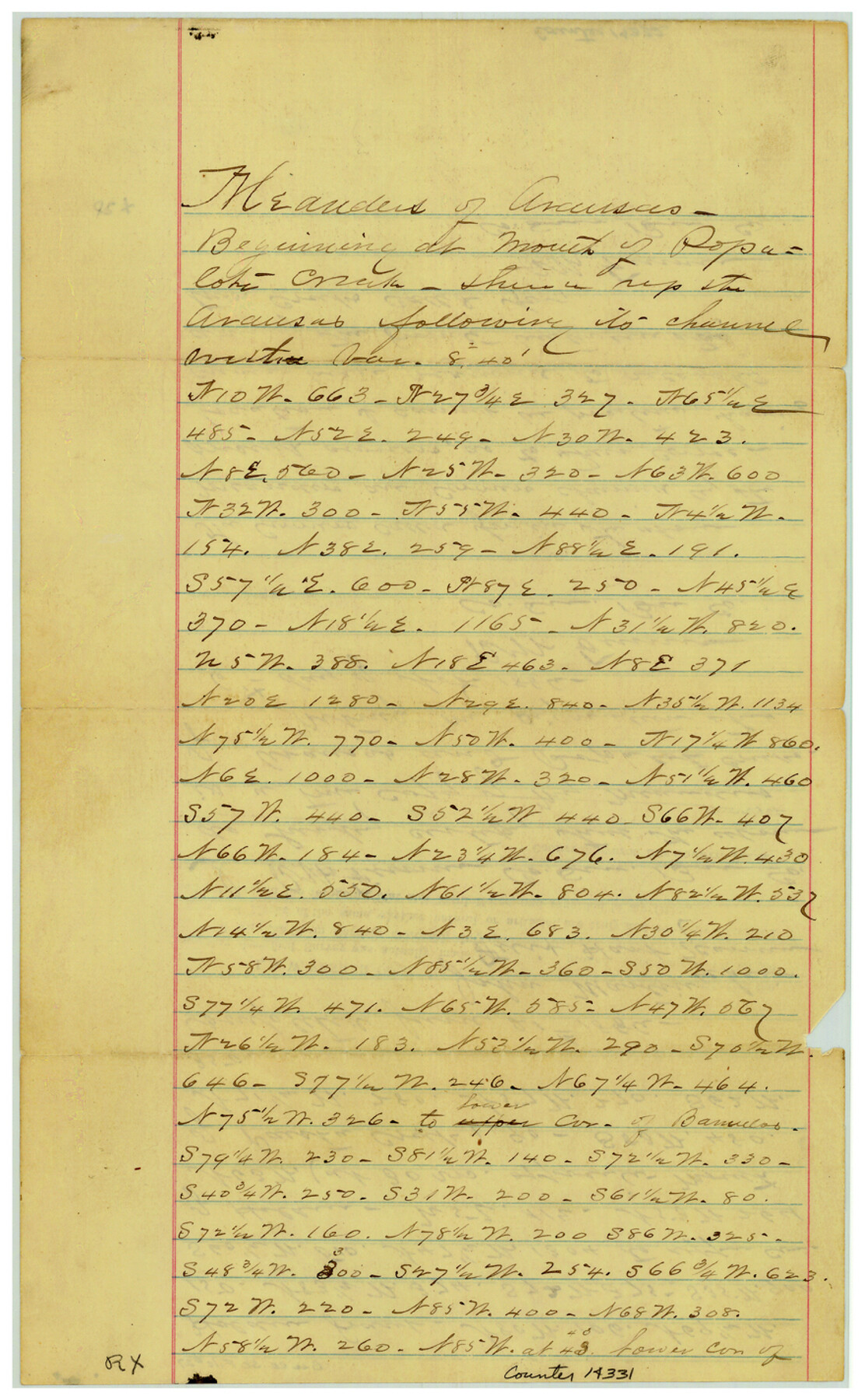
Bee County Sketch File 27
[Field notes of the meanders of Papalote and Aransas Creeks]
-
Map/Doc
14331
-
Collection
General Map Collection
-
Object Dates
1886/6/18 (Creation Date)
1886/11/12 (File Date)
-
People and Organizations
R.W. Fenner (Surveyor/Engineer)
John Martin (Chainman/Field Personnel)
Felix Hart (Chainman/Field Personnel)
-
Counties
Bee
-
Subjects
Surveying Sketch File
-
Height x Width
14.3 x 8.8 inches
36.3 x 22.4 cm
-
Medium
paper, manuscript
-
Features
Papalote Creek
Paesta Creek
Boggy Creek
Silver Creek
Part of: General Map Collection
Township 7 South Range 13 West, South Western District, Louisiana

Print $20.00
- Digital $50.00
Township 7 South Range 13 West, South Western District, Louisiana
1879
Size 19.7 x 24.7 inches
Map/Doc 65887
Kimble County Working Sketch 27

Print $20.00
- Digital $50.00
Kimble County Working Sketch 27
1934
Size 16.1 x 17.3 inches
Map/Doc 70095
Cottle County Working Sketch Graphic Index

Print $20.00
- Digital $50.00
Cottle County Working Sketch Graphic Index
1971
Size 41.8 x 33.8 inches
Map/Doc 76506
Brazoria County Working Sketch 37

Print $40.00
- Digital $50.00
Brazoria County Working Sketch 37
1981
Size 43.5 x 66.0 inches
Map/Doc 67522
Falls County Sketch File 10

Print $14.00
- Digital $50.00
Falls County Sketch File 10
Size 12.9 x 8.4 inches
Map/Doc 22345
Throckmorton County Rolled Sketch 4

Print $20.00
- Digital $50.00
Throckmorton County Rolled Sketch 4
1993
Size 23.0 x 35.0 inches
Map/Doc 7990
Southern Part of Laguna Madre

Print $20.00
- Digital $50.00
Southern Part of Laguna Madre
1973
Size 44.2 x 35.2 inches
Map/Doc 73543
Cass County Working Sketch 46

Print $20.00
- Digital $50.00
Cass County Working Sketch 46
1989
Size 26.8 x 30.6 inches
Map/Doc 67949
Flight Mission No. DCL-5C, Frame 72, Kenedy County

Print $20.00
- Digital $50.00
Flight Mission No. DCL-5C, Frame 72, Kenedy County
1943
Size 18.7 x 22.5 inches
Map/Doc 85855
Moore County Working Sketch 6

Print $20.00
- Digital $50.00
Moore County Working Sketch 6
1921
Size 16.0 x 14.5 inches
Map/Doc 71188
Harris County Working Sketch 57

Print $20.00
- Digital $50.00
Harris County Working Sketch 57
1951
Size 21.7 x 20.0 inches
Map/Doc 65949
Maps of Gulf Intracoastal Waterway, Texas - Sabine River to the Rio Grande and connecting waterways including ship channels

Print $20.00
- Digital $50.00
Maps of Gulf Intracoastal Waterway, Texas - Sabine River to the Rio Grande and connecting waterways including ship channels
1966
Size 14.6 x 22.2 inches
Map/Doc 61967
You may also like
Dallam County Sketch File 15

Print $18.00
- Digital $50.00
Dallam County Sketch File 15
1990
Size 14.4 x 9.0 inches
Map/Doc 20381
General Highway Map. Detail of Cities and Towns in Jefferson County, Texas / 1961

Print $20.00
General Highway Map. Detail of Cities and Towns in Jefferson County, Texas / 1961
1961
Size 18.2 x 24.6 inches
Map/Doc 79538
Anderson County Working Sketch 32

Print $20.00
- Digital $50.00
Anderson County Working Sketch 32
1966
Size 23.7 x 21.9 inches
Map/Doc 67032
[Sketch for Mineral Application 24072, San Jacinto River]
![65587, [Sketch for Mineral Application 24072, San Jacinto River], General Map Collection](https://historictexasmaps.com/wmedia_w700/maps/65587.tif.jpg)
Print $20.00
- Digital $50.00
[Sketch for Mineral Application 24072, San Jacinto River]
1929
Size 19.3 x 16.4 inches
Map/Doc 65587
Lee County Working Sketch 2

Print $20.00
- Digital $50.00
Lee County Working Sketch 2
1945
Size 17.8 x 19.5 inches
Map/Doc 70381
Flight Mission No. DAG-24K, Frame 130, Matagorda County

Print $20.00
- Digital $50.00
Flight Mission No. DAG-24K, Frame 130, Matagorda County
1953
Size 17.1 x 18.8 inches
Map/Doc 86548
Bell County Sketch File 26a

Print $4.00
- Digital $50.00
Bell County Sketch File 26a
1883
Size 9.0 x 9.6 inches
Map/Doc 14433
Layout of the porciones as described in the Visita General of Laredo, 1767

Layout of the porciones as described in the Visita General of Laredo, 1767
2009
Size 11.0 x 8.5 inches
Map/Doc 94042
Flight Mission No. DQO-8K, Frame 18, Galveston County

Print $20.00
- Digital $50.00
Flight Mission No. DQO-8K, Frame 18, Galveston County
1952
Size 18.6 x 22.4 inches
Map/Doc 85141
[Surveys along the Trinity River]
![321, [Surveys along the Trinity River], General Map Collection](https://historictexasmaps.com/wmedia_w700/maps/321.tif.jpg)
Print $2.00
- Digital $50.00
[Surveys along the Trinity River]
Size 3.6 x 3.7 inches
Map/Doc 321
Flight Mission No. DAG-24K, Frame 149, Matagorda County

Print $20.00
- Digital $50.00
Flight Mission No. DAG-24K, Frame 149, Matagorda County
1953
Size 18.4 x 16.2 inches
Map/Doc 86563
King County Rolled Sketch 9

Print $20.00
- Digital $50.00
King County Rolled Sketch 9
Size 25.9 x 34.2 inches
Map/Doc 9350