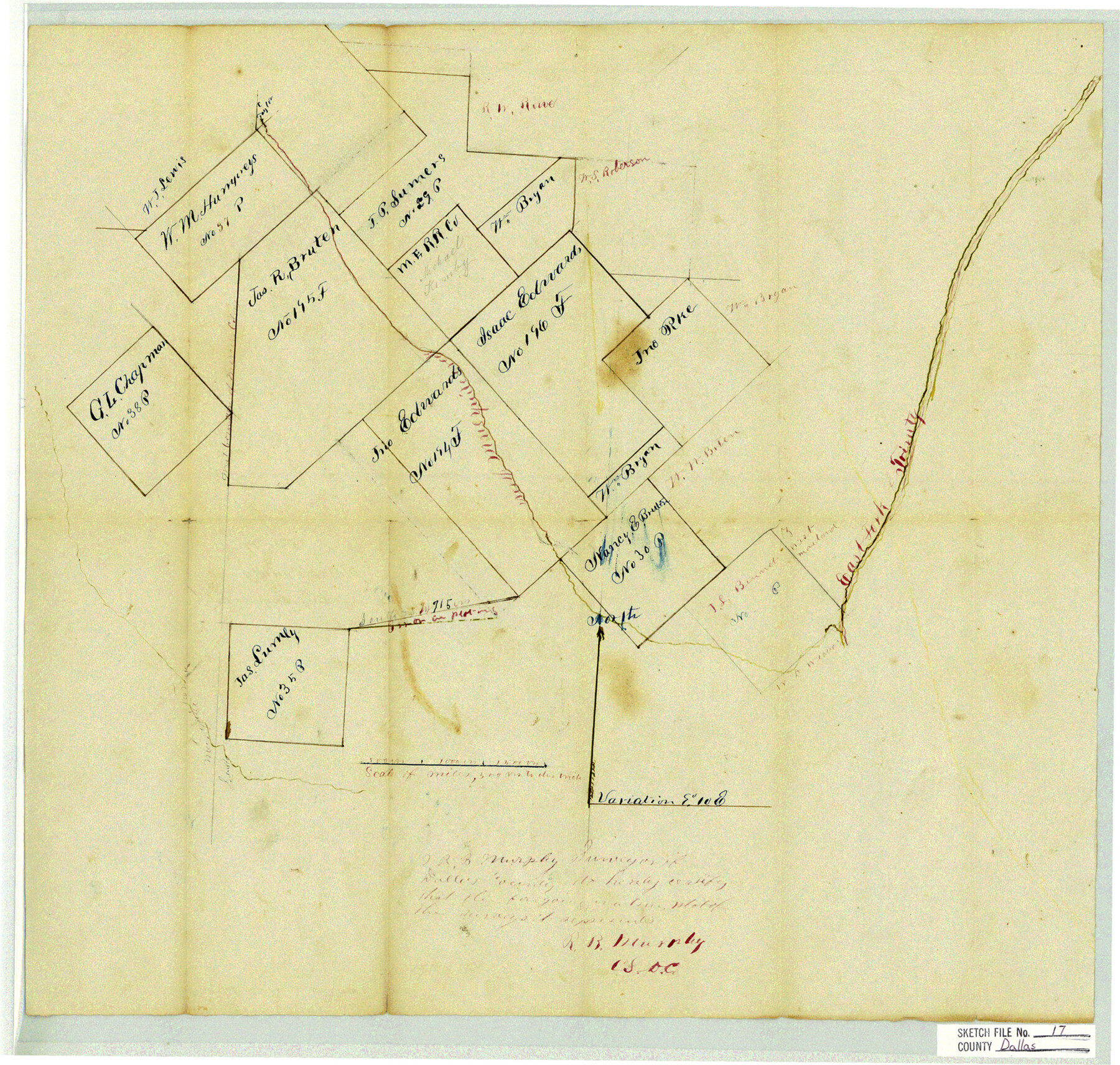
Dallas County Sketch File 17
Mouth of Mesquite Cr.
-
Map/Doc
11285
-
Collection
General Map Collection
-
Object Dates
1871/8/17 (File Date)
-
People and Organizations
R.B. Murphy (Surveyor/Engineer)
-
Counties
Dallas
-
Subjects
Surveying Sketch File
-
Height x Width
17.1 x 18.0 inches
43.4 x 45.7 cm
-
Medium
paper, manuscript
-
Scale
1:500
-
Features
East Fork Trinity River
West Mesquite Creek
Part of: General Map Collection
Gordonville Quadrangle

Print $20.00
- Digital $50.00
Gordonville Quadrangle
1999
Size 35.4 x 23.4 inches
Map/Doc 97362
Harrison County Working Sketch 25

Print $20.00
- Digital $50.00
Harrison County Working Sketch 25
1983
Size 21.9 x 24.0 inches
Map/Doc 66045
Current Miscellaneous File 77

Print $10.00
- Digital $50.00
Current Miscellaneous File 77
1900
Size 11.0 x 8.8 inches
Map/Doc 74194
Hudspeth County Working Sketch 32

Print $20.00
- Digital $50.00
Hudspeth County Working Sketch 32
1972
Size 21.6 x 31.7 inches
Map/Doc 66316
Coleman County Sketch File 46

Print $20.00
- Digital $50.00
Coleman County Sketch File 46
1894
Size 24.0 x 21.8 inches
Map/Doc 11125
Jackson County Sketch File 15

Print $13.00
- Digital $50.00
Jackson County Sketch File 15
Size 13.5 x 8.8 inches
Map/Doc 27662

Chart of the Rio Bravo del Norte traced from a survey made by Henry Austin by Lieut. Bowman, 3d. Infy.

Print $20.00
- Digital $50.00
Chart of the Rio Bravo del Norte traced from a survey made by Henry Austin by Lieut. Bowman, 3d. Infy.
1866
Size 18.3 x 27.8 inches
Map/Doc 72889
Cass County Sketch File 1

Print $4.00
- Digital $50.00
Cass County Sketch File 1
1857
Size 11.6 x 8.2 inches
Map/Doc 17392
Haskell County Sketch File 16

Print $32.00
- Digital $50.00
Haskell County Sketch File 16
1894
Size 11.2 x 8.8 inches
Map/Doc 26163
Flight Mission No. DAG-21K, Frame 128, Matagorda County

Print $20.00
- Digital $50.00
Flight Mission No. DAG-21K, Frame 128, Matagorda County
1952
Size 18.4 x 22.3 inches
Map/Doc 86454
La Salle County Sketch File 27

Print $22.00
- Digital $50.00
La Salle County Sketch File 27
Size 8.8 x 14.1 inches
Map/Doc 29553
You may also like
Flight Mission No. BQR-22K, Frame 47, Brazoria County

Print $20.00
- Digital $50.00
Flight Mission No. BQR-22K, Frame 47, Brazoria County
1953
Size 18.8 x 22.4 inches
Map/Doc 84131
Crockett County Sketch File 35c

Print $8.00
- Digital $50.00
Crockett County Sketch File 35c
Size 14.3 x 8.8 inches
Map/Doc 19746
Matagorda Bay Oil Area, Matagorda, Calhoun & Jackson Cos.

Print $40.00
- Digital $50.00
Matagorda Bay Oil Area, Matagorda, Calhoun & Jackson Cos.
1927
Size 34.9 x 66.8 inches
Map/Doc 2934
Maverick County Working Sketch 14

Print $20.00
- Digital $50.00
Maverick County Working Sketch 14
1970
Size 41.2 x 42.6 inches
Map/Doc 70906
Angelina County Working Sketch 22a

Print $20.00
- Digital $50.00
Angelina County Working Sketch 22a
1953
Size 22.3 x 20.1 inches
Map/Doc 67103
[Drawings of individual counties for Pressler and Langermann's 1879 Map of Texas]
![[Drawings of individual counties for Pressler and Langermann's 1879 Map of Texas]](https://historictexasmaps.com/wmedia_w700/maps/4863.tif.jpg)
Print $20.00
- Digital $50.00
[Drawings of individual counties for Pressler and Langermann's 1879 Map of Texas]
1878
Size 38.8 x 26.8 inches
Map/Doc 4863
Galveston County Sketch File 1

Print $4.00
- Digital $50.00
Galveston County Sketch File 1
Size 12.7 x 8.5 inches
Map/Doc 23346
Jackson County Working Sketch 4

Print $20.00
- Digital $50.00
Jackson County Working Sketch 4
1941
Size 34.1 x 28.5 inches
Map/Doc 66452
Pecos County Sketch File 27A

Print $20.00
- Digital $50.00
Pecos County Sketch File 27A
Size 26.7 x 19.8 inches
Map/Doc 12166
Bailey County Rolled Sketch 7

Print $40.00
- Digital $50.00
Bailey County Rolled Sketch 7
1941
Size 67.1 x 43.1 inches
Map/Doc 8931
San Patricio County NRC Article 33.136 Sketch 10

Print $692.00
San Patricio County NRC Article 33.136 Sketch 10
2023
Map/Doc 97294
Energy Map of Texas Ornament

Price $20.00
Energy Map of Texas Ornament
2021
Size 2.5 x 2.5 inches
Map/Doc 96574