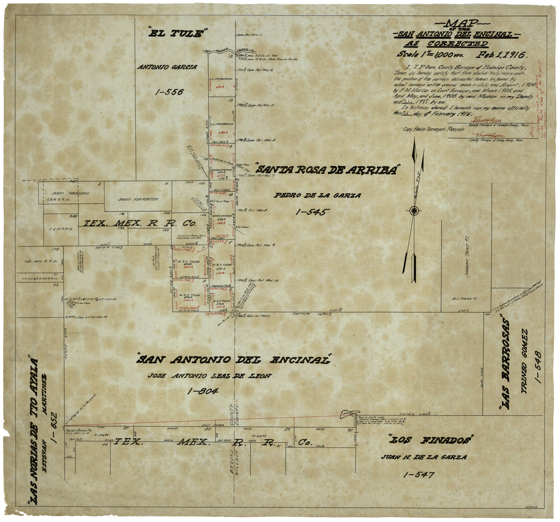
Map of the San Antonio del Encinal as Corrected
-
Map/Doc
4456
-
Collection
Maddox Collection
-
Object Dates
2/1/1916 (Creation Date)
-
People and Organizations
Thos. P. Gore (Surveyor/Engineer)
E.F. Maddox (Draftsman)
F.M. Maddox (Surveyor/Engineer)
-
Counties
Brooks Willacy Kenedy
-
Height x Width
28.5 x 30.6 inches
72.4 x 77.7 cm
-
Medium
paper, etching/engraving/lithograph
-
Scale
1" = 1000 varas
-
Comments
Map labeled as Willacy County, but is present day Kenedy County.
Surveyed by F. M. Maddox - July and August 1904; March 1905; April, May and June 1906.
Surveyed by Thos. P. Gore - July 1915. -
Features
Los Olmos Creek
Falfurrias to Monte Negro Road
Jarita Lake
Falfurrias Road
Monte Negro Road
San Antonio del Encinal
Santa Rosa de Arriba
Las Barrosas [Ranch]
Las Norias de Tio Ayala
Los Finados
Part of: Maddox Collection
Foard County, Texas

Print $20.00
- Digital $50.00
Foard County, Texas
1891
Size 19.5 x 20.7 inches
Map/Doc 727
[Surveying sketch of P. Castleman, H. George, et al in Wichita County]
![389, [Surveying sketch of P. Castleman, H. George, et al in Wichita County], Maddox Collection](https://historictexasmaps.com/wmedia_w700/maps/0389-1.tif.jpg)
Print $20.00
- Digital $50.00
[Surveying sketch of P. Castleman, H. George, et al in Wichita County]
Size 12.6 x 24.5 inches
Map/Doc 389
[Sketch Showing Surveys in Dimmit County, Texas]
![5045, [Sketch Showing Surveys in Dimmit County, Texas], Maddox Collection](https://historictexasmaps.com/wmedia_w700/maps/5045.tif.jpg)
Print $20.00
- Digital $50.00
[Sketch Showing Surveys in Dimmit County, Texas]
Size 20.1 x 16.7 inches
Map/Doc 5045
Survey of Lots 1, 2, 3, 4 and 5, Block 12G Fair View Park, Austin Texas

Print $20.00
- Digital $50.00
Survey of Lots 1, 2, 3, 4 and 5, Block 12G Fair View Park, Austin Texas
1914
Size 23.1 x 11.0 inches
Map/Doc 83431
Working Sketch in Baylor and Throckmorton Cos.

Print $20.00
- Digital $50.00
Working Sketch in Baylor and Throckmorton Cos.
1890
Size 24.2 x 20.8 inches
Map/Doc 75771
Stephens County, Texas

Print $20.00
- Digital $50.00
Stephens County, Texas
1870
Size 21.0 x 17.7 inches
Map/Doc 756
Map of Bexar County, Texas

Print $20.00
- Digital $50.00
Map of Bexar County, Texas
1879
Size 25.1 x 29.7 inches
Map/Doc 530
Map of Brazoria County, Texas

Print $20.00
- Digital $50.00
Map of Brazoria County, Texas
1879
Size 28.0 x 26.5 inches
Map/Doc 589
Map of Clay County, Texas

Print $20.00
- Digital $50.00
Map of Clay County, Texas
1880
Size 33.0 x 23.2 inches
Map/Doc 699
Map of the C.C. Browning survey 412 enlarged from General Land Office map of the west part of Travis County, Texas

Print $3.00
- Digital $50.00
Map of the C.C. Browning survey 412 enlarged from General Land Office map of the west part of Travis County, Texas
1920
Size 11.3 x 9.1 inches
Map/Doc 10752
Schleicher County

Print $20.00
- Digital $50.00
Schleicher County
1898
Size 23.1 x 36.3 inches
Map/Doc 615
[Kenney's sketch of the surveys in Dickens and Motley Counties]

Print $20.00
- Digital $50.00
[Kenney's sketch of the surveys in Dickens and Motley Counties]
1905
Size 20.1 x 15.7 inches
Map/Doc 367
You may also like
Stephens County Sketch File 23

Print $12.00
- Digital $50.00
Stephens County Sketch File 23
1919
Size 11.1 x 8.8 inches
Map/Doc 37084
Galveston County Sketch File 58

Print $20.00
- Digital $50.00
Galveston County Sketch File 58
1984
Size 47.1 x 38.3 inches
Map/Doc 10458


Harris County Working Sketch 107

Print $20.00
- Digital $50.00
Harris County Working Sketch 107
1981
Size 46.0 x 28.1 inches
Map/Doc 65999
Brewster County Sketch File 49

Print $26.00
- Digital $50.00
Brewster County Sketch File 49
1994
Size 14.2 x 8.8 inches
Map/Doc 16329
Flight Mission No. BRE-1P, Frame 68, Nueces County

Print $20.00
- Digital $50.00
Flight Mission No. BRE-1P, Frame 68, Nueces County
1956
Size 17.7 x 21.8 inches
Map/Doc 86650
Armstrong County Sketch File A-4

Print $40.00
- Digital $50.00
Armstrong County Sketch File A-4
Size 14.8 x 20.5 inches
Map/Doc 10845

Hutchinson County

Print $20.00
- Digital $50.00
Hutchinson County
1891
Size 19.7 x 24.5 inches
Map/Doc 91155
Terrell County Rolled Sketch 53

Print $20.00
- Digital $50.00
Terrell County Rolled Sketch 53
Size 33.1 x 24.2 inches
Map/Doc 7971
Right of Way and Track Map, the Missouri, Kansas and Texas Ry. of Texas - Henrietta Division

Print $20.00
- Digital $50.00
Right of Way and Track Map, the Missouri, Kansas and Texas Ry. of Texas - Henrietta Division
1918
Size 11.8 x 26.8 inches
Map/Doc 64762