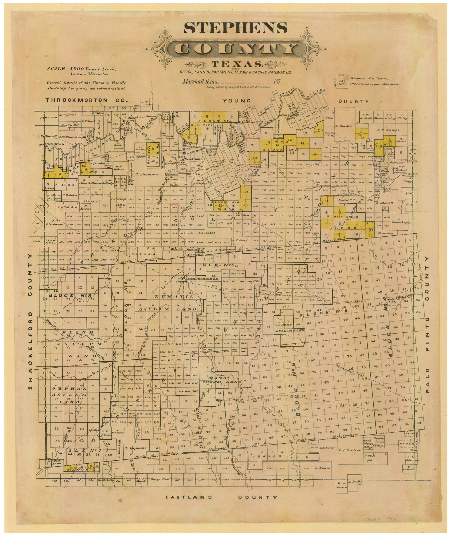
Stephens County, Texas
-
Map/Doc
756
-
Collection
Maddox Collection
-
Object Dates
[1870 ca.] (Creation Date)
-
People and Organizations
Texas and Pacific Railroad Company (Publisher)
August Gast & Co. (Lithographer)
-
Counties
Stephens
-
Subjects
County
-
Height x Width
21.0 x 17.7 inches
53.3 x 45.0 cm
-
Scale
1" = 4000 varas
-
Comments
Conservation funded in 2011.
"Lithographed by August Gast & Co's new process" -
Features
Road to Belle Plain
15 Mile Creek
Battle Creek
Breckenridge Road
Stephenville Road
Stephenville & Breckenridge Road
Weatherford Road
Wayland P.O.
Duck Creek
Fort Griffin & Stephenville Road
45 Mile Creek
Old Fort Davis
Caddle P.O.
Fort Griff[in] Road
Breckenridge
East Fork [of Hubbard's Creek]
West Fork [of Hubbard's Creek]
Hubbard's Creek
Camp Cooper Road
Palo Pinto Road
Palo Pinto & Camp Cooper Road
Clear Fork of the Brazos River
Part of: Maddox Collection
Terlingua Special Map, The University of Texas Mineral Survey, Brewster County, Texas

Print $20.00
- Digital $50.00
Terlingua Special Map, The University of Texas Mineral Survey, Brewster County, Texas
1902
Size 20.4 x 22.6 inches
Map/Doc 482
Map of Newton County, Texas

Print $20.00
- Digital $50.00
Map of Newton County, Texas
1893
Size 35.0 x 15.2 inches
Map/Doc 587
Lipscomb County, Texas

Print $20.00
- Digital $50.00
Lipscomb County, Texas
1880
Size 16.5 x 18.2 inches
Map/Doc 489
Sketch showing connections made in survey of the Jerry Barton preemption

Print $20.00
- Digital $50.00
Sketch showing connections made in survey of the Jerry Barton preemption
1892
Size 18.7 x 23.6 inches
Map/Doc 75557
[Sketch of 'San Salvador del Tule', Juan Jose Balli Grant, Hidalgo County, Texas]
![10756, [Sketch of 'San Salvador del Tule', Juan Jose Balli Grant, Hidalgo County, Texas], Maddox Collection](https://historictexasmaps.com/wmedia_w700/maps/10756.tif.jpg)
Print $20.00
- Digital $50.00
[Sketch of 'San Salvador del Tule', Juan Jose Balli Grant, Hidalgo County, Texas]
Size 22.0 x 17.5 inches
Map/Doc 10756
Map of Kimble County, Texas

Print $20.00
- Digital $50.00
Map of Kimble County, Texas
1879
Size 18.1 x 28.3 inches
Map/Doc 527
Gillespie County, Texas

Print $20.00
- Digital $50.00
Gillespie County, Texas
1879
Size 21.2 x 26.9 inches
Map/Doc 547
Nueces County, Texas

Print $20.00
- Digital $50.00
Nueces County, Texas
1879
Size 29.3 x 40.0 inches
Map/Doc 590
[Sketch of Sullivan Property]
![75775, [Sketch of Sullivan Property], Maddox Collection](https://historictexasmaps.com/wmedia_w700/maps/75775.tif.jpg)
Print $20.00
- Digital $50.00
[Sketch of Sullivan Property]
Size 14.3 x 22.7 inches
Map/Doc 75775
Midland County, Texas

Print $20.00
- Digital $50.00
Midland County, Texas
1888
Size 22.4 x 17.5 inches
Map/Doc 653
Plat of Surveys in Hidalgo Co.

Print $20.00
- Digital $50.00
Plat of Surveys in Hidalgo Co.
Size 18.3 x 9.2 inches
Map/Doc 75548
Exhibit A to the Surveyors Report, R.W. Lillard vs J.M. Taylor, et al

Print $20.00
- Digital $50.00
Exhibit A to the Surveyors Report, R.W. Lillard vs J.M. Taylor, et al
1881
Size 12.4 x 12.9 inches
Map/Doc 683
You may also like
Foard County Sketch File X1

Print $40.00
- Digital $50.00
Foard County Sketch File X1
Size 17.6 x 14.2 inches
Map/Doc 22800
The Republic County of Shelby. December 14, 1837

Print $20.00
The Republic County of Shelby. December 14, 1837
2020
Size 21.1 x 21.7 inches
Map/Doc 96279
Fisher County Rolled Sketch Y

Print $20.00
- Digital $50.00
Fisher County Rolled Sketch Y
Size 42.1 x 25.4 inches
Map/Doc 5878
Flight Mission No. DCL-7C, Frame 28, Kenedy County

Print $20.00
- Digital $50.00
Flight Mission No. DCL-7C, Frame 28, Kenedy County
1943
Size 15.4 x 15.4 inches
Map/Doc 86020
Liberty County Rolled Sketch 18

Print $11.00
- Digital $50.00
Liberty County Rolled Sketch 18
1859
Size 10.1 x 15.2 inches
Map/Doc 46540
Murphy and Bolanz' Index Map of Greater Dallas

Print $20.00
- Digital $50.00
Murphy and Bolanz' Index Map of Greater Dallas
1911
Size 20.3 x 18.3 inches
Map/Doc 96794
Packery Channel

Print $3.00
- Digital $50.00
Packery Channel
1972
Size 10.6 x 17.8 inches
Map/Doc 2999
Blanco County Sketch File 22

Print $4.00
- Digital $50.00
Blanco County Sketch File 22
1884
Size 8.7 x 15.5 inches
Map/Doc 14604
Northeast Part of Webb County

Print $40.00
- Digital $50.00
Northeast Part of Webb County
1986
Size 37.7 x 50.0 inches
Map/Doc 95668
[Sketch of a portion of Hutchinson County, Texas]
![413, [Sketch of a portion of Hutchinson County, Texas], Maddox Collection](https://historictexasmaps.com/wmedia_w700/maps/0413.tif.jpg)
Print $20.00
- Digital $50.00
[Sketch of a portion of Hutchinson County, Texas]
1889
Size 14.9 x 17.3 inches
Map/Doc 413
Harris County Working Sketch 121

Print $20.00
- Digital $50.00
Harris County Working Sketch 121
1985
Size 34.4 x 18.6 inches
Map/Doc 66013
La Salle County Rolled Sketch 25

Print $20.00
- Digital $50.00
La Salle County Rolled Sketch 25
Size 20.3 x 24.4 inches
Map/Doc 6586